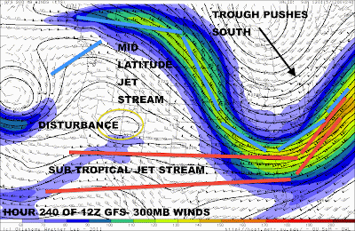
We are watching the potential for a storm system to affect the East US. The system we are watching is the area circled in yellow. This system will be moving eastward from the Pacific. We can see several factors in play. First, we have the subtropical jet stream in the south that will likely have the most influence on the storm system as the storm system is closest to the subtropical jet stream. Another factor is the mid-latitude jet stream, or the jet stream you hear about on the TV or in newspapers. This jet stream will be wailing at over 120 MPH way back up in Canada before dipping south. Here's where things get interesting: It appears that the subtropical jet stream and this mid-latitude jet stream may be phasing together. This is seen as a larger jet stream after the proposed crossroads, as well as higher-speed winds. These jet streams may be forced together by the strong storm system moving south. This strong system, if it continues moving south, would essentially strengthen the jet stream even more, as pressure on the two jet streams would increase. Eventually, the system will be swept into the jet stream and be thrown out to sea. Following that, if there will be no more strong systems moving south, the mid-latitude jet stream would fling back north to its regular position.
The disturbance would continue to move east. Now, there is another proposed idea of what would happen if the jet stream moved too far south. If it moved too far south, it may move north over the system so it would be closer to its original position. If that happened, the storm system would most definitely go more NW than what would be anticipated. As of right now, thinking that the aforementioned scenario will not happen, the disturbance outlined in yellow would move across the South, and then out to sea. But if this huge disturbance pushing the jet streams down is swept east before the original disturbance is, we would see the storm system likely affect the Great Lakes and Midwest.
All in all, what does that mean?
It means that this could be a snowstorm for anyone in the East US. It depends on this very strong storm system, as well as jet stream placement, as well as if the original disturbance will even be present. So this is just a heads up.
We will continue looking into this, as many factors could complicate forecasts for this storm.


5 comments:
Hello Andrew.I just saw something like this on hour 240 on the ECMWF model.
accuweather is already predicting over 7 inches by the 17th for mora,mn....... I'm so happy I hope it stalls for a while so it piles way up!
So does this storm look to give Central Illinois any snow? Or do we know yet?
Hello Andrew.So what are the models doing with storm today?Any guess who all would be affeceted by this storm?Like for instance do you think it will affect the midwest,ohio valley,great lakes,and the northeast.
Cummins99: That seems a bit too long range for me to be confident in.
Owen: We do not know yet.
Mike: We can have an update out later on about it.
Post a Comment