Wednesday, July 14, 2010
Weather World- Iowa
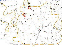
CAPES (Measure of instability) are at a STUNNING 8000 in Iowa.
2000= severe weather event threshold
4000+= extremely unstable.
If a SHOWER were to pop up in that area, i fully expect it to produce extreme hail, extreme winds, and violent tornadoes. But that's unlikely...for now.
Dew points are at 80 in that area as well.
temps in the 90's.
2000= severe weather event threshold
4000+= extremely unstable.
If a SHOWER were to pop up in that area, i fully expect it to produce extreme hail, extreme winds, and violent tornadoes. But that's unlikely...for now.
Dew points are at 80 in that area as well.
temps in the 90's.
Pressure change (Midwest)
A pressure change of 1 has occured in the last few hours in the western US, and a 2 pressure point change has occured in the North Dakota area. This makes a conclusion of a low pressure system forming in the Southern Canada area.
GFS model
Showers and storms on Day 3
Showers on Day 4
Showers on Day 5
Potentially strong to severe storms on Day 6
Potentially strong storms on Day 7
Showers on Day 4
Showers on Day 5
Potentially strong to severe storms on Day 6
Potentially strong storms on Day 7
Subscribe to:
Comments (Atom)

