Saturday, June 30, 2012

Analysis of the June 29, 2012 Derecho

This is an analysis of the June 29, 2012 Derecho that hit the Ohio Valley and Mid Atlantic.

The derecho's beginnings were in eastern Iowa, as a complex of thunderstorms that moved eastward into northern Illinois. As the complex moved into Illinois, a shelf cloud was observed, with this being among the many pictures taken.

From Northern Illinois, the complex began a southeast motion and passed through Indiana. As the storms moved into Indiana, they began to strengthen under the influence of more than 5000 j/kg of instability. This development was slightly hindered by the presence of a capping inversion, as noted on the 12z soundings in Indiana.
The cluster began to bow out as it entered central Indiana, as significant instability enhanced the bowing segment to the point of developing a derecho. However, in the early stages, storm reports and radar analysis indicate that hail was present on the western flank of the bowing complex before it switched to a major damaging wind threat.
Moving into the evening, the bowing complex was now a powerhouse derecho, at this time responsible for numerous reports of hurricane strength wind speeds, including a roughly 90 MPH wind gust clocked in Fort Wayne, Indiana. Needless to say, the damage form this derecho only increased as the complex continued on its way. In the evening hours, the storms encountered some fair shearing in the atmosphere, which led to rotating cells. One of them is seen below, at approximately 5:51 PM CDT. At that point in time, the derecho had become comma-shaped, with this tornado-warned cell leading the head of the comma.


Despite the presence of rotating cells, only two unconfirmed tornadoes were reported. Those reports originated from Newcomerstown, Ohio.

A composite radar image of the derecho shows just how widespread and destructive the complex was, with the strongest cells seen in Ohio. Weakening did occur after the derecho passed through Ohio, but still continued to produce damage into the Mid Atlantic states. The derecho did span roughly 600 miles when it was all set and done, not counting its presence in Iowa and Illinois.


Storm reports from the derecho were widespread, with 920 wind damage reports filed into the National Weather Service offices across the Ohio Valley and Mid Atlantic. Notice the slacking off of reports in the Mid Atlantic. That comes as the derecho hit the Appalachian Mountain range, and those mountains did indeed cut down on the power of the system. However, as observed right along the coast, there was still considerable damage from the derecho until the very end.

In summary:
A derecho formed June 29, 2012 in northern Indiana. It then fanned out into a powerful complex of damaging thunderstorms, in which at least 8 people lost their lives. This derecho spanned 600 miles and produced countless wind speeds surpassing 60 MPH. Millions of dollars in damage will likely be used to repair what has been lost.

Andrew

Long Range Analysis: ECMWF - GFS

Discussion

GFS and ECMWF in good agreement over high pressure remaining in place over much of the United States in the next 8-10 days, providing unrelenting heat to flourish across the country. Models also agree in extension of ridge north into western Canada, where it will act to hold a deep low pressure system in place over the Gulf of Alaska, and an atmospheric traffic jam looks to be forming.
Both models also indicate the presence of a low pressure system in southeast Canada. However, the ECWMF does give this disturbance more strength and has the ridge in western Canada weaker than the GFS. Essentially, the ECMWF appears more inclined to break down the traffic jam. If this break down would occur, the low pressure system would likely be shoved down south into the eastern US. The ridge in the US would be pushed east, and the ridge in Canada would get moving and allow the Gulf of Alaska's low pressure system to skirt along the US/Canada border and likely ignite some severe weather in the Northern Plains along the still-existing Ring of Fire. However, it is suggested that the central and eastern US would be free of the heat due to a shifting MJO into Phase 2. The ECMWF ensemble system has the MJO stay in Phase 2 at fluctuating strengths, which all-in-all would lead to a cooler eastern US.

Andrew

Round Two for Ohio Valley; Northern Plains in Severe Risk Today

A slight risk of severe weather has been issued for the Mid Atlantic and Ohio Valley into the Midwest, as well as the Northern Plains.

Surface analysis indicates low pressure is present in the Northern Plains. With a warm front nearby, the atmosphere should begin to destabilize along the front. Pop up thunderstorms could begin with rotation due to the influence of the low pressure's wind field and the proximity to the 'Ring of Fire'. Soundings validate the presence of a capping inversion in the lower leves of the atmosphere, but with instability prominent in the mid levels of the atmosphere.

Sounding analysis across the Ohio Valley and Mid Atlantic indicates a capping inversion is in place, with nearly 1000 j/kg of CINH in place. This should hold down storm development until the afternoon. There is some indication that an EML (Elevated Mixed Layer) has overspread parts of the Mid Atlantic, and this could also hinder storm development for that area. (An Elevated Mixed Layer, in a nutshell, is something that hinders storm development.)

Expectation is for scattered yet strong storms to develop in both areas of severe weather risk area per RAP model guidance. The areas are so big due to the scattered-ness of the storms and a general 'safety risk' to cover all areas that have a potential for storms that could turn severe, rather than covering small, individual areas that the models say will get struck.

Andrew

Hot High Pressure System to Settle In for Next 10 Days (Or More)

The high pressure system currently over much of the United States that is providing for high temperatures and drought conditions looks like it is settling in for at least the next 10 days. Let's take a look at two different ensembles from two agencies.

This image is from the NCEP Ensembles of the National Centers for Environmental Prediction (NCEP). This image is valid for 9 days out, and you can see that the ridge remains in place over a week from today. However, notice the low pressure system just north of the upper Great lakes. This disturbance is forecast by the NCEP ensembles to push south and essentially evacuate the high pressure system to the Western US. This disturbance's southward movement would happen 10 days from now.


This next ensemble set is the Earth System Research Laboratory (ESRL)'s Physical Sciences Division (PSD) Ensembles. You may notice that this image says hour 240 and the previous image says hour 216. That is because the NCEP ensembles initiated at 0z last night, while the PSD Ensembles above initiated at 0z 2 nights ago. Either way, both images end up at 9 days from today. The PSD Ensembles still show the ridge of high pressure over the US, but a low pressure system appears to be dipping into the Northeast rather than the NCEP's idea of a disturbance dipping into the Great Lakes. However, in both cases, the high pressure system is pushed west. It should be noted that the PSD ensembles are weaker with the ridge than the NCEP Ensembles.

So what does this all mean?
I expect the hot temperatures to continue to flourish across the nation. Thunderstorm location along the Ring of Fire is in the air. The reason? the 5880 line. It is common that storms cannot form above the 5880 line in the 500mb part of the atmosphere. So, the 5880 line can be used to forecast thunderstorms. That is why the location is up for grabs, as the 5880 line differs in the ensembles.

Andrew

Friday, June 29, 2012

June 29, 2012 Severe Thunderstorm Clouds

Copyright Vortex Weather Phoography

A Week of the Same Heat, Storms On The Way

The image shown below is the forecast at the 500mb level off the NCEP ensembles. Typically, as we have seen today, thunderstorms are inclined to form along the rim of such summer high pressure systems. This continuous thunderstorm threat makes for the nickname of the 'Ring of Fire', for the intense storms that can move along the rim of the high pressure ridge.
If we see this dome of heat keep sitting over the area, the next 7 days could very well be more of what we saw today with storms in the Midwest, Ohio Valley, and Northern Plains.
Now, a few days after the image below, a storm system looks to push south and move the high pressure system west. However, the NCEP ensembles appear torn on that idea, which means it may never happen and the ridge just keeps in place.
This may be just as bad, as the Colorado fires could be helped or harmed by either storms along the rim of the ridge of high pressure, or the heat and sun from being inside the ridge.

Andrew

Derecho Moving Through Ohio Valley; Moderate Risk Issued


Damaging Wind Probability
A moderate risk of severe weather has been issued by the Storm Prediction Center as a derecho moves through the Ohio Valley towards the Mid Atlantic. This is the same complex that gave me such pictures that I have posted on the Facebook pictures.

Radar imagery suggests these storms are very powerful, with intense gust fronts being shot out very fast. Severe thunderstorm warnings indicate violent winds of 80 MPH are expected.
Anyone in the moderate risk should immediately prepare for potentially life-threatening wind damage.

Andrew

Triple Threat for Severe Weather Tomorrow

There are three areas of severe weather potential tomorrow across the eastern US. The largest risk area involves the Ohio Valley and Mid Atlantic into a portion of the Northeast. The other two risk areas are stationed in the Northern Plains.

At this time, the most risk appears to be placed in the Mid Atlantic-Ohio Valley risk outline as a frontal boundary initiates convective development for that area.
More on this risk later today and tomorrow.

Andrew

Elongated Severe Weather Risk Cuts Through Nation's Midsection Today

The Storm Prediction Center has outlined an elongated region of severe weather potential across the Mid Atlantic into the Ohio Valley, back up through the lower Great Lakes and Northern Plains.

A sagging cold front will nearly stall out across these regions today, prompting the potential for storms at any given time of the day. 12z soundings from across the severe weather potential area show vast areas of instability, with over 7000 j/kg of CAPE located in the most unstable part of the lowest 700mb of the atmosphere. Today, the most unstable part of the lower 700mb is roughly in the 900mb level, which is very close to the surface, indicating that storms that fire could have a lot of energy right off the bat.
I am not going to use the RAP for today's forecast because it has severely underestimated CAPE values for 12z in its soundings forecasts. However, the HRRR model does fire a mesoscale convective system (MCS) around 1:00 PM CDT and shifts it south and east into the night as it works across the severe weather potential area delineated above by the SPC.

As for what the SPC put out, it appears the main threats are damaging wind and hail, and the center of those threats should be in northern Indiana and Ohio.

Andrew

Colorado Wildfire Forecasts: June 29, 2012

Flagstaff Wildfire near Boulder, CO

High: 96
Wind: North between 3-11 MPH, gusts as high as 16 MPH.
Humidity: 14%
Dewpoint: 36
Precipitation Potential: 10%

High Park Wildfire near Fort Collins, CO


High: 97
Wind: Calm becoming south at 7-10 MPH. Gusts as high as 16 MPH.
Humidity: 15%
Dewpoint: 38
Precipitation Potential: 10%

Thursday, June 28, 2012

Wyoming, Utah Do Not Escape Wildfires

Wyoming and Utah are not escaping the wildfire dangers on this day, as the Fontenelle fire rages in Wyoming, and the Church Camp and Wood Hollow wildfires on the prowl in Utah.

This is part of continuing coverage of the devastating 2012 wildfires in the West.

Andrew

Waldo Canyon Fire Smoke Visible on Satellite

The Waldo Canyon wildfire is quite visible on satellite imagery as at least half a dozen wildfires burn throughout Colorado.
The firefighters are getting a break today, as winds are shifting, chances for rain are coming, and humidities are rising. Wind changes can actually go either way, but let's keep optimistic here.
This is a part of continuous coverage on the Colorado wildfires.

Andrew

Colorado Wildfire Forecasts: June 28, 2012

Boulder, CO (Flagstaff Wildfire)

High: 97 (F)
Chance of Precipitation: 20% (after noon)
Dew Point: 43 (F)
Winds: West winds 6-12 MPH with gusts as high as 18 MPH.

Fort Collins, CO (High Park Wildfire)

High: 98 (F)
Chance of Precipitation: 20% (after 2 PM)
Dew Point: 43 (F)
Winds: West winds 6-10 MPH becoming south.

Andrew

Thunderstorm Potential a Toss-Up in Midst of Heat

(This post focuses on northern IL and eastern IA after my concerns of the SPC downgrading the severe weather threat for those areas today.)

The models continue to indicate vast amounts of instability in the regions mentioned above, but coverage of any storms that manage to form looks isolated. Here is the forecast from the 2 km run of the WRF from the University of Illinois at Urbana-Champaign. This is valid at 2:00 PM CDT today.

The model shows small pop-up showers and storms striking northern Illinois, with the 20 hour forecast (1 hour later) showing a blossoming storm cell in northeast Illinois.
There will likely be some trouble with convection, as models are showing cloud bases in the 1000-2000 meter range. Considering the cold front coming through will be weak, this could very well be an issue that will stop growth of thunderstorms.

After reviewing the fact that there will be a lot of instability at hand but not a lot of forcing, I think that there is indeed a chance of thunderstorms in north Illinois and southern Wisconsin into east Iowa. However, these storms will become severe should they form. I will have more updates on the Facebook page.

Andrew

Wednesday, June 27, 2012

Slight Risk of Severe Weather Tomorrow

There is a slight risk of severe weather tomorrow over northern Illinois and eastern Iowa as a cold front moves in to ward off unusually hot temperatures for that region of the country.

Instability is forecast to be on the high end, not surprising for 100 degree heat. The Storm Prediction Center does mention the potential for 4000-5000 j/kg of instability, which is indeed very high. The NAM indicates a small area of enhanced rotation potential over northern Illinois, slanted more towards the area south of Chicago, IL going into extreme northwest Indiana. Over the general lower Great Lakes region, there could be a widespread weak capping inversion, which would likely be crushed by at least 3000 j/kg of instability currently being projected by the NAM.
The GFS is bullish on instability, placing over 5000 j/kg of potential energy over northern Illinois, whereas the NAM centers the instability into the Upper Midwest. Additionally, the GFS disintegrates capping potential in Northern Illinois, opting to place any inversion to the south of a line roughly following Interstate 80. There looks to be some shearing in southern Wisconsin and areas west, igniting potentials for some supercellular structures of which the Storm Prediction Center does find plausible. Precipitation values off the GFS at roughly 7:00 PM CDT tomorrow do indicate what could be a small cluster of storms, or an area of cells in northern Illinois. These could reach severe limits and will have to be watched in future forecasts.

Andrew

Ominous Heat Wave to Expand North Tomorrow

Heat related advisories are up as the nation prepares for a bout with menacing 100 degree heat tomorrow. There are excessive heat warnings in action in eastern Kansas and western Missouri, where the center of the heat should be placed. Heat index values could flirt with 110 degrees. In dark maroon, in northwest Illinois and east Iowa, an excessive heat watch is in effect, meaning that there is the potential that those areas could see an excessive heat warning out of this. Much more common on the map is orange, which signifies heat advisories. Chicago, IL, St. Louis, MO, and Indianapolis, IN are among the major cities in the heat advisories. I would not be surprised to see St. Louis go under an excessive heat warning for this event, with highs flirting with 110.

Forecast high temperatures for tomorrow extend an arm of 100 degree heat from Kansas through the Midwest and edging into the Ohio Valley. A swath of near-100 degree heat will also be present in the southern Mississippi valley into portions of the Southeast. 90 degree readings look to be in place throughout the Northern Plains and East Coast tomorrow as well.

In order to limit health-related illness risk tomorrow, it is advised that you:
-Drink plenty of water at all times.
-Do as little high labor activities outside as possible.
-Check on elderly neighbors.
-If you have pets, keep them in a cool area with a water source.

Tomorrow is not the day to go run a 5K or bike several miles in the afternoon. This heat will pose a threat to life, but can be avoided if you keep hydrated and don't do high energy activity.

Andrew

Tuesday, June 26, 2012

Civil Emergency Message- Voluntary Evacuation- Suwannee County, FL

FLC121-270800-

URGENT - IMMEDIATE BROADCAST REQUESTED
CIVIL EMERGENCY MESSAGE
FLORIDA EMERGENCY MANAGEMENT AGENCY JACKSONVILLE FLORIDA
RELAYED BY NATIONAL WEATHER SERVICE JACKSONVILLE FL
552 PM EDT TUE JUN 26 2012

THE FOLLOWING MESSAGE IS TRANSMITTED AT THE REQUEST OF SUWANNEE
COUNTY EMERGENCY MANAGEMENT.

THERE IS A VOLUNTARY EVACUATION OF LOW-LYING AREAS AND LOCATIONS
NEAR RIVERS...STREAMS...AND CREEKS IN SUWANNEE COUNTY.

A SHELTER HAS BEEN OPENED AT THE COLISEUM...1302 11TH
STREET...LIVE OAK. PEOPLE WHO DECIDE TO EVACUATE LOW LYING AREAS
SHOULD USE EXTREME CAUTION...AND SHOULD NOT CROSS FLOODED
ROADWAYS.

OTHERWISE...TRAVEL ACROSS SUWANNEE COUNTY IS STRONGLY DISCOURAGED.
THE SUWANNEE COUNTY SHERIFF`S OFFICE REQUESTS THAT PEOPLE STAY AT
HOME AND OFF THE ROADS TONIGHT. NUMEROUS ROADS ARE UNDER
WATER...SEVERAL FEET DEEP IN SOME LOCATIONS.

A BOIL WATER NOTICE IS IN EFFECT FOR ALL OF SUWANNEE COUNTY. BRING
WATER TO A FULL ROLLING BOIL FOR AT LEAST ONE MINUTE AND ALLOW TO
COOL BEFORE DRINKING OR USING IN FOOD PREPARATION.

IF YOU HAVE FLOODING IMPACTING YOUR HOME...YOU CAN CALL THE
FOLLOWING PHONE NUMBER FOR ASSISTANCE..386-364-3405

Civil Emergency Message- Voluntary Evacuation- Nassau County, FL (Jacksonville, FL)

FLC089-270400-

URGENT - IMMEDIATE BROADCAST REQUESTED
CIVIL EMERGENCY MESSAGE
FLORIDA EMERGENCY MANAGEMENT AGENCY JACKSONVILLE FLORIDA
RELAYED BY NATIONAL WEATHER SERVICE JACKSONVILLE FL
655 PM EDT TUE JUN 26 2012

THE FOLLOWING MESSAGE IS TRANSMITTED AT THE REQUEST OF NASSAU
COUNTY EMERGENCY MANAGEMENT.

THERE IS A VOLUNTARY EVACUATION OF LOW-LYING AREAS IN NASSAU
COUNTY. A SHELTER HAS BEEN OPENED AT THE HILLIARD MIDDLE-SENIOR
HIGH SCHOOL...ONE FLASHES AVENUE. PEOPLE WHO DECIDE TO EVACUATE
LOW-LYING AREAS SHOULD USE EXTREME CAUTION...AND SHOULD NOT CROSS
FLOODED ROADWAYS.

IF YOU HAVE FLOODING IMPACTING YOUR HOME...YOU CAN CALL THE
FOLLOWING PHONE NUMBER FOR ASSISTANCE: 904-548-4980 OR 911 FOR AN
EMERGENCY

Dust Storm Warning- Tucson, AZ

URGENT - WEATHER MESSAGE
NATIONAL WEATHER SERVICE TUCSON AZ
359 PM MST TUE JUN 26 2012


AZZ502>505-515-270100-
/O.NEW.KTWC.DS.W.0004.120626T2259Z-120627T0100Z/
TOHONO O`ODHAM NATION-UPPER SANTA CRUZ RIVER VALLEY/ALTAR VALLEY-
TUCSON METRO AREA-SOUTH CENTRAL PINAL COUNTY-
BABOQUIVARI MOUNTAINS-
INCLUDING THE CITY OF...PICACHO PEAK STATE PARK
359 PM MST TUE JUN 26 2012

...DUST STORM WARNING IN EFFECT UNTIL 6 PM MST THIS EVENING...

THE NATIONAL WEATHER SERVICE IN TUCSON HAS ISSUED A DUST STORM
WARNING...WHICH IS IN EFFECT UNTIL 6 PM MST THIS EVENING.

* TIMING...THUNDERSTORMS GENERATING STRONG OUTFLOWS CONTINUE TO
PUSH NORTHWEST ACROSS CENTRAL PINAL COUNTY NEAR THREE POINTS...AND
WILL BUILD NORTHWEST ACROSS CENTRAL PIMA COUNTY AND THE TOHONO
OODHAM NATION.

* WINDS...40 TO 60 MPH WITH STRONGEST OUTFLOWS.

* VISIBILITY...BELOW A QUARTER MILE AT TIMES.

* IMPACTS...SEVERE VISIBILITY RESTRICTIONS WITH VERY HAZARDOUS
DRIVING CONDITIONS


PRECAUTIONARY/PREPAREDNESS ACTIONS...

A DUST STORM WARNING MEANS SEVERELY LIMITED VISIBILITIES ARE
EXPECTED WITH BLOWING DUST. BLOWING DUST CAN QUICKLY REDUCE
VISIBILITY...CAUSING ACCIDENTS THAT MAY INVOLVE CHAIN COLLISIONS
AND MULTIPLE PILEUPS. IF DENSE DUST IS OBSERVED BLOWING ACROSS OR
APPROACHING A ROADWAY...PULL YOUR VEHICLE OFF THE PAVEMENT AS FAR
AS POSSIBLE TO STOP. TURN OFF THE LIGHTS...SET THE EMERGENCY
BRAKE...AND TAKE YOUR FOOT OFF OF THE BRAKE PEDAL TO ENSURE BRAKE
LIGHTS ARE NOT ILLUMINATED.

PERSONS WITH RESPIRATORY PROBLEMS SHOULD STAY INDOORS UNTIL THE
STORM PASSES.

Heat Related Warnings, Watches Flying

Heat related warnings and watches are being thrown up throughout the center of the country in advance of a heat wave that should reach its peak on Thursday, when places like Chicago could meet or slightly surpass 100 degrees. Much more on this tomorrow.

Andrew

Debby Makes Landfall in Florida

Imagery from the Advanced Dvorak Technique system (ADT) is showing the center of Debby just onshore Florida, indicating that Debby has indeed made landfall. Debby is expected to then shift east and out to sea.

Andrew

Buoy in Eye of Debby Records 60 Knot Wind Gust

Buoy SGOF1, just offshore of Florida, was in the eye of Debby and did record the highest wind gust I have seen from Debby.

SGOF1 observed a wind gust of nearly 60 knots, which equates to roughly 70 MPH. Considering that this is how strong Debby was just offshore, it makes things a little more believable as to any wind damage that has been observed on land.

Andrew

Tropics Forecast Looking Relatively Modest

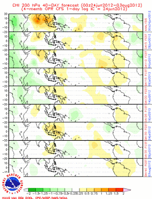
The forecast off the CFS of the MJO is looking like we may see some activity by Africa. Enhanced convection appears to be in the works in that region in the next couple weeks, with another bout of storminess by late July. The MJO should support low opportunities for tropical cyclone formation in the East Pacific in the next few weeks, and this could continue into August.

The movement of this convection shows me that the MJO should stay within Phases 8-3 for a while as dry conditions stay farther towards Asia, and enhanced convection appears in the Atlantic. However, getting into July, we see dry conditions spread east, signaling a progressing MJO into the middle phases.

So what does all of this mean? I am expecting potentially another opportunity for tropical development in the eastern Atlantic as the MJO favors enhanced convection in that area. Additionally, there should be below normal thunderstorm activity in the Eastern Pacific due to unfavorable upper level winds.

Andrew

Heat Wave to Obliterate Records on Thursday

Temperature Records for Thursday are expected to be demolished as a massive dome of heat moves over the central US, as pictured in this NAM forecast from Twisterdata. Much of the central and southern US is shown to receive temperatures flirting with or surpassing 100 degrees. Chicago's forecast is for 100 degrees, and 110 degrees+ looks to be possible for portions of Kansas.

Now, this is unsurprisingly a skeptical forecast. Temperatures this high in these places is not common in the slightest. While not exactly rare, when this magnitude of a heat wave arrives, records are usually broken. However, a glance at some NWS forecast discussions reveal that the GFS is appearing too cool with this event. For that reason, I am using the NAM for this forecast.

Andrew

Debby to Ram Florida, Be Pushed Out to Sea

Tropical Storm Debby has begun to move east at 3 MPH, and this very slow movement is expected to continue until late Wednesday, when Debby begins to rev up and crash into Florida. When Debby does crash into Florida, it can be expected that weakening into a tropical depression will occur.

Following the Florida landfall, the NHC track takes Debby on a curving northeast path that appears to be going out to sea. Considering a climatologically favorable track is for Debby to curve up the coast and possibly hit New England (like many winter storms), that would be a favored option. However, the forecast models are finally in agreement that Debby should be kicked out to sea from the get-go after leaving Florida.

This seems likely, considering a cold front with trailing high pressure will be pushing south, resulting in a squeeze of Debby eastward. At that point, Debby will be too far away from the coast to hug it.

Andrew

Monday, June 25, 2012

Tornado Warning- Richmond, VA


BULLETIN - EAS ACTIVATION REQUESTED
TORNADO WARNING
NATIONAL WEATHER SERVICE WAKEFIELD VA
244 PM EDT MON JUN 25 2012

THE NATIONAL WEATHER SERVICE IN WAKEFIELD HAS ISSUED A

* TORNADO WARNING FOR...
  NORTH CENTRAL CHESTERFIELD COUNTY IN CENTRAL VIRGINIA...
  SOUTHEASTERN GOOCHLAND COUNTY IN CENTRAL VIRGINIA...
  SOUTH CENTRAL HANOVER COUNTY IN CENTRAL VIRGINIA...
  WESTERN HENRICO COUNTY IN CENTRAL VIRGINIA...
  CITY OF RICHMOND IN CENTRAL VIRGINIA...

* UNTIL 315 PM EDT

* AT 241 PM EDT...NATIONAL WEATHER SERVICE DOPPLER RADAR INDICATED A
  TORNADO. THIS DANGEROUS STORM WAS LOCATED NEAR MANAKIN...OR NEAR
  TUCKAHOE...AND MOVING SOUTHEAST AT 40 MPH.

* THIS DANGEROUS STORM WILL BE NEAR...
  TUCKAHOE...LAUREL...GLEN ALLEN AND BON AIR AROUND 250 PM EDT.
  LAKESIDE AROUND 255 PM EDT.
  DOWNTOWN RICHMOND AROUND 300 PM EDT.
  EAST HIGHLAND PARK AROUND 305 PM EDT.

OTHER LOCATIONS IMPACTED BY THIS DANGEROUS STORM INCLUDE ROSLYN
HILLS...GREENDALE...LONGDALE...DUMBARTON...SOLOMONS STORE...
CHAMBERLAYNE AND MONTROSE.

Potentially Deadly Heat Wave Strikes Thursday

This image, from the Hydrometeorological Prediction Center (HPC), projects maximum temperatures for Thursday, where many cities are widely expected to break triple digits. While it says maximum temperatures, these could very well turn out to be the temperatures on Thursday. Among cities that could experience unusually intense heat are:

-Chicago, IL (100)
-Indianapolis, IN (100)

Those are just the cities that almost never reach 100. There are many cities that could flirt with 110, especially in Kansas.

In situations like this, ALWAYS carry a water bottle and do not perform high energy activities for an extended period of time (or at all, if possible), because the scope and intensity of this heat is not as frequent as you think.

Andrew

All Eyes on Florida as Debby Preps for Landfall

The weather world is focused on Florida today as tropical storm warnings fly in advance of the landfall of Tropical Storm Debby later this week. The NHC projects Debby to remain nearly stationary over the next few days, before making its move Thursday morning and striking Florida. The main rain shield has already been torn off of the system, and it is very possible that the exposed center of circulation could bring Debby down to a tropical depression before landfall happens. Additionally, some dry air in the western Gulf of Mexico could pose an issue for development on that side of the circulation center.

The top half of the picture is cut off for a reason.
This image from the Hydrometeorological Prediction Center (HPC) of 5 day rainfall illustrates the potentially deadly threat that Florida faces from Debby despite recent weakening, with the HPC suggesting nearly a foot and a half of solid rain could fall in isolated portions of Florida, especially on the Gulf Coast side. Already, flash flooding is an issue in Florida from Debby, and if this forecast verifies, travel by boat (or ark) would be the preferred mode of transportation.

Andrew

Buoys Record Tropical Storm Debby's Strength

Buoy 42046 in the Gulf of Mexico, west northwest of Tampa Bay, FL, recorded a minimum pressure reading of roughly 29.42 inches as Debby moved over the region. You can clearly see the time when Debby actually entered the immediate vicinity of the buoy, which was around 7:00 PM CDT 2 nights ago. Overnight, and throughout yesterday and last night, pressures have dropped by nearly half an inch.


An observation station in Clearwater Beach, Florida recorded a wind gust at 50 knots (roughly 57 MPH) in the evening hours last night as the intense part of Debby moved over the area. Since then, wind gusts have been restricted to the 25-35 knot mark, and have been stabilizing throughout the morning into the 25-30 knot range.

Something also pretty interesting, from buoy 42036, was the significant wave height, which topped out at nearly 18 feet. Think about that- 18 feet wave heights. That's like something that the crab fishers in 'Deadliest Catch' would experience, out in the Bering Sea.

Updates will continue throughout the day.

Andrew

Rain Shield of Debby is Torn Away; Weakening Begins

Imagery shown above indicates that the strongest part of Debby, AKA the rain shield, has been torn away from the center of circulation. The circulation is currently just south of the Florida Panhandle, while the rain is southeast of Georgia at this time. Because the protection of rain and storms around the center are gone, weakening appears likely and has been happening overnight, from 60 MPH to 50 MPH wind speeds.
Debby's center of circulation is also large for a tropical storm and loosely defined. Considering all of what I typed above, it seems more than likely that some additional weakening should occur.

Andrew

Sunday, June 24, 2012

Buoy Data Suggests Debby Wind Gusts Surpass 50 Knots

Wind gust data at the KVOA buoy indicates that wind gusts really began to fluctuate during the day today, but wind speeds have really accelerated this afternoon and evening, with gusts over 50 knots having been observed roughly an hour ago.

Pressures at nearby buoy 42376 have been dropping over the last several days, with nearly 29.65 millibars this evening. The dropping pressure indicates that Debby has been strengthening with time. Since Debby is nearly stationary, and pressures continue to drop despite no movement, it is only logical that Debby is genuinely strengthening and that this does not appear to be movement of the storm.

More updates will continue for the rest of tonight and into tomorrow and beyond on the Facebook page and here.

Andrew

Debby To Cut Across Florida; East Coast Be Wary

Latest model guidance and surface observations suggest to me that Tropical Storm Debby will move eastward and cut across Florida before heading up the East Coast.

Debby will likely hit at or slightly above what I have projected on here, depending on how far north or south Debby ends up at the time of eastward movement. Debby should make landfall on Florida and incite potentially major flooding, with a few inches already laid out across the dry landscape. The soil may not be able to immediately soak in the water due to the dryness of the ground, so some flash flooding is not off the table. A tornado threat will continue to be present.
After Florida, Debby will most likely track along the East Coast. How close to the coast remains a question. Right now I am thinking that some clouds and stray showers could brush up against the coast, but major effects seem unlikely. Debby should remain a tropical storm throughout the rest of her life, with a brief potential for very weak Category 1 Hurricane status.

Andrew

Debby Track Still a Toss Up; Florida Landfall Seeming More Possible

The National Hurricane Center has shifted eastward, and now calls for a landfall in Louisiana, dangerously close to New Orleans, Louisiana. Considering that Katrina hit that region several years ago, the threat of a tropical system making another landfall will likely put many residents on edge.
However, the track remains very up in the air. I took a glance at GFS Ensemble members, and they are literally all over the place. The majority of them appear to take a Florida path before going out to sea. Here is a look at dynamical models from the 12z model suite.

http://raleighwx.americanwx.com/models/atcf/12zatcfearlyinvest2best.gif
The models shown above here show a favored track into the Florida region. It should be noted, however, that there remains a spread in potential track from Florida into Texas. At this point in time, it seems probable that a Florida landfall is likely at this point in time.

More updates will appear on the Facebook page as well as on here.
Andrew

Tropical Storm Debby May Become Hurricane This Week


The National Hurricane Center is showing Debby to move west-northwest across the Gulf of Mexico, and become a hurricane as it does so. Tropical storm warnings have also been issued for portions of the Louisiana Gulf of Mexico Coast, the Alabama coast, and the Florida Panhandle also has a warning on it. These warnings are for the outer rain bands rather than a landfall at this point.

From: NAVY/NRL TC_PAGES Page
Satellite imagery shows how strong the rain bands are across Florida. The center is also visible, and we can see those strong rain bands trying to wrap around the center. Should this wrapping happen, it would indicate that the central pressures are lowering and we are seeing the system getting itself together.

I will be providing updates all day long on Debby on the Facebook Page, with updates also on the blog here.

Andrew

Saturday, June 23, 2012

Tropical Storm Debby Eyes Texas

The National Hurricane Center is forecasting Debby to make a turn northwest tomorrow and head due west towards southern Texas, confirming recent CMC/ECMWF model suspicions. Debby is forecast to remain a tropical storm throughout the next several days, but this forecast could change with time.
Tropical Storm Warnings are now in effect along the eastern half of the Louisiana coast, as Debby will likely incite a little flooding and windy conditions with outer rain bands swiping the area. The major cities at risk for effects from this storm include: New Orleans (LA) and Corpus Christi (TX), with Houston (TX) possibly also getting affected by this event.

Andrew

BREAKING: Tropical Storm Debby has Formed

Data from the hurricane hunters indicates that there are several reports of the system having tropical storm strength winds. Thus, Invest AL96 is now likely going to be classified as Tropical Storm Debby in the next NHC update.

Andrew

Invest 96 May Become Debby This Weekend in Gulf of Mexico

The National Hurricane Center, or NHC, has placed a system in the Gulf of Mexico at a 90% chance for tropical cyclone formation in the next 48 hours. Satellite imagery indicates clouds beginning to show signs of wrapping around a center, with outer cloud bands beginning to form in Georgia.
Considering that the strongest convection is located in the eastern part of the storm, with little or no convection on the western portion, we will need to have convection either bloom or significantly wrap around a central low pressure area to have the system develop a hurricane eye and strengthen properly as a tropical cyclone.

A glance at the tropical models suite reveals a very split decision, with some models hitting Florida, some hitting Texas, and some just wandering the system around the Gulf of Mexico. Looking individually at the models, the CMC has changed to hitting Louisiana, after hitting Texas for 4 consecutive runs. Whether this Louisiana scenario remains possible will have to be seen in the 12z model run. The ECMWF keeps consistent with a Texas/Mexico border hit, making that the 3rd consecutive time that scenario has been shown by the ECMWF.

I'm not willing to put in an opinion right now due to the volatility of the models right now, but will continue updating on the system.

Andrew