Monday, December 13, 2010

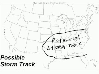
New Potential Storm Track for LP2 (see Snow Centre)

STORM TRACK MAP COMES OUT
Short Range Forecaster still unsure
This is the Short Range Forecaster for The Weather Centre, here with the potential storm track for the low forecast to come through the South US. As the title indicates, I am still very unsure, justifying the large area of the storm track. A new SnowMap will come out tomorrow afternoon, as will a new Snow Bulletin.

Image from PSWC, writing from me.

Arctic Outbreak in Full Fury

Revised MW/GL/Plains SnowMap

MIDWEEK CLIPPER THREATENS MIDWEST
Indications of 2-4'' is Great Lakes areas
This is your Short Range Forecaster for the Weather Centre here to deliver the newly produced SnowMap. What these snows are a product of are actually a stalling clipper way up in Canada. But it will likely produced a prolonged impact upon some cities in the Great Lakes and Midwest. While this SnowMap highlights the main potential for hard hit areas, the Upper Midwest, Great Lakes, and a majority of the Midwest will likely receive at least a dusting. The next SnowMap will likely come out either tonight or tomorrow. For updates, the Snowfall Centre is always open, and the Snow Bulletin has just been updated. Stay tuned.