Tuesday, March 15, 2011

2011 Canada Tornado Forecast

Tornadoes are historically proven to be common in certain regions in the South Central Canada regions.
A couple concerns arise with this fact coupled with other forecast elements.
First, the Gulf of Mexico will be open to the Midwest and East Plains this Spring. With severe storms likely to flourish in those areas, some of that moisture will make it to South Canada. If a low pressure system arrives with cold, dry air, severe storms are possible. This will be an important concern for the tornado season.
Also, La Nina will be in effect for the Spring. La Nina creates cooler conditions in the US, and some of that cold comes into the Canadian regions.
Considering those elements, below is the official Weather Centre Canada Tornado Forecast.

March 15 2011 Forecast Discussion

FORECAST DISCUSSION
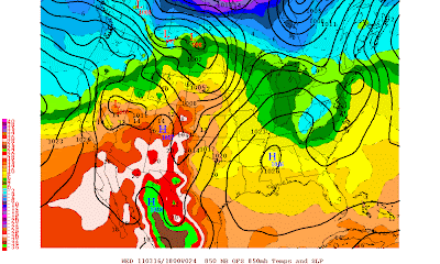
This is the image from the 18z GFS 24 hours from now.
High pressure over the Mississippi area will prevent any storms from reaching the area, but some showers and possibly storms can be expected as a fairly cool air mass slides across the nation's midsection. These storms that could develop would not be severe.
Into the Plains, tight isobars will allow for a fairly gusty day tomorrow as high pressure mentioned above pumps up warm air to the low pressure system in Canada. So with that influx of warm air will be windy.
Main concern with this forecast discussion is somewhat strong low pressure system in Canada. This system will be begin manipulating the high pressure stationed in Mississippi to allow dry, warm air from the Arizona area to collide with moist, warm air from the Gulf. The dry air and humid air will collide to make a somewhat more moist environment across the northern US portions. As the low pressure system moves off east, it will pull the warm air with it. Tight isobars in the Plains mentioned above will allow for a fast transport of warm, humid Gulf air. Drier Mexico air will also integrate into that air, leaving still only a relatively moist environment. The strength of this low will allow for that open flow of warm air to continue. As that low strengthens, the high pressure won't need to be manipulated anymore, and may begin to make way for the low pressure. I predict the high to begin and move offshore at some point as the warm air transport area is dragged across the US.
Other Concerns include the somewhat cool air mass stationed over the Northeast and Carolinas. Should that air mass still keep its cool, the warm air mass may begin to spout rain and storms in the Carolinas region. However, this 18z GFS run indicates high pressure mentioned above will move north and eliminate that air mass as the warm air transport and low pressure system move east. As that warm air transport system works east, the Midwest can be prepared for a windy day as the transport moves overhead. However, it will be a welcome relief from frosty mornings recently experienced.
New Forecast Discussion will be issued tomorrow.

NOAA records 17th warmest February on Record

(NOAA Press Release)
Global Temperature Highlights – February
  • The combined global land and ocean average surface temperature for February 2011 was the 17th warmest on record at 54.62 F (12.50 C), which is 0.72 F (0.40 C) above the 20th century average of 53.9 F (12.1 C). The margin of error associated with this temperature is +/- 0.18 F (0.10 C).
  • Separately, the global land surface temperature was 0.92 F (0.51 C) above the 20th century average of 37.8 F (3.2 C), which tied for the 28th warmest February on record. The margin of error is +/- 0.56 F (0.31 C). Warmer-than-average conditions occurred across most of Asia, central Africa, northern Alaska and southern Greenland. Cooler-than-average regions included Eastern Europe, western Russia, eastern Siberia and the western United States.
  • The February global ocean surface temperature was 0.65 F (0.36 C) above the 20th century average of 60.6 F (15.9 C), making it the 10th warmest February on record. The margin of error is +/- 0.13 F (0.07 C). The warmth was most pronounced across the northern Pacific Ocean, the tropical Atlantic Ocean and part of the North Atlantic near Greenland and Canada.
Global Temperature Highlights – December 2010 – February 2011
  • The combined global land and ocean average surface temperature for Northern Hemisphere winter (December 2010 – February 2011) was 0.70 F (0.39 C) above the 20th century average of 53.8 F (12.1 C), making it the 16th warmest on record. The margin of error is +/- 0.16 F (0.09 C).
  • The December 2010 – February 2011 worldwide land surface temperature was 0.81 F (0.45 C) above the 20th century average of 37.8 F (3.2 C) — the 26th warmest such period on record. The margin of error is +/- 0.32 F (0.18 C). Warmer-than-average conditions were particularly felt across eastern Canada, southern Greenland and northern Siberia. Cooler-than-average regions included Eastern Europe, western Russia and Mongolia.
  • The global ocean surface temperature for December 2010 – February 2011 was 0.65 F (0.36 C) above the 20th century average of 60.5 F (15.8 C) and tied for the 10th warmest such period on record. The margin of error is +/-0.13 F (0.07 C). The warmth was most pronounced across the northern Pacific Ocean, the tropical Atlantic Ocean, and the North Atlantic, near Greenland and Canada.
  • La Niña conditions weakened in February, although sea-surface temperatures remained below normal across the central and eastern equatorial Pacific Ocean. According to NOAA’s Climate Prediction Center, La Niña will continue to have global impacts for the next several months, but neither La Niña nor El Niño are expected to affect the region by June.
Polar Sea Ice and Precipitation Highlights
  • The average Arctic sea ice extent for February was 5.54 million square miles (14.36 million square km), which is 8.2 percent below average. This ties with February 2005 as the smallest February Arctic sea ice extent since records began in 1979 and is the third consecutive month with record low Arctic ice extent.
  • For the winter period, the Northern Hemisphere snow cover extent over land averaged 760,000 square miles (1.98 million square km) above average, ranking as the third largest seasonal snow cover extent on record behind the winters of 1977–1978 and 2009–2010. The North American season snow cover extent was the third largest on record, while Eurasia’s was fourth largest.
  • Average rainfall across Australia was 76 percent above average during February, making it the second wettest February on record behind 2000. Rainfall in South Australia was more than four times above average, the wettest February on record for the state. The summer period (December 2010 – February 2011) was the second wettest summer on record for Australia.

Whole Pacific Plate appears to be shaking.


The entire Pacific Plate appears to have been disturbed by the 9.0 Earthquake Japan experienced. The result from this 9.0 earthquake is increased activity in the west coast of South and North America, Alaska to Japan to the Philippines, then Papua New Guinea, even down into the 'Southern East Pacific Rise'.
Below is a real-time earthquake map. If you are able to draw a ring connecting all those squares around the Pacific, you have found the Pacific Plate.