THE NATIONAL WEATHER SERVICE IN BISMARCK HAS ISSUED A

* TORNADO WARNING FOR...
  NORTHWESTERN MORTON COUNTY IN SOUTH CENTRAL NORTH DAKOTA...

* UNTIL 900 PM CDT

* AT 821 PM CDT...NATIONAL WEATHER SERVICE DOPPLER RADAR INDICATED A
  SEVERE THUNDERSTORM CAPABLE OF PRODUCING A TORNADO. THIS DANGEROUS
  STORM WAS LOCATED NEAR GLEN ULLIN...OR 46 MILES EAST OF
  DICKINSON...AND MOVING NORTHEAST AT 15 MPH.

* LOCATIONS IMPACTED INCLUDE...
  MAINLY RURAL AREAS OF NORTHWESTERN MORTON COUNTY.

PRECAUTIONARY/PREPAREDNESS ACTIONS...

LAW ENFORCEMENT INDICATED A LARGE ROTATING WALL CLOUD WITH A FUNNEL.

TAKE COVER NOW. MOVE TO AN INTERIOR ROOM ON THE LOWEST FLOOR OF A
STURDY BUILDING. AVOID WINDOWS. IF IN A MOBILE HOME...A VEHICLE OR
OUTDOORS...MOVE TO THE CLOSEST SUBSTANTIAL SHELTER AND PROTECT
YOURSELF FROM FLYING DEBRIS.

REPORT SEVERE WEATHER TO THE NATIONAL WEATHER SERVICE IN BISMARCK AT
701-223-4582.
Sunday, June 12, 2011
June 12- Tornado Warning (Large Rotating Wall Cloud, Funnel Reported)- Near Dickinson, ND
June 12- Final Bulletin on Post-Tropical Cyclone Adrian
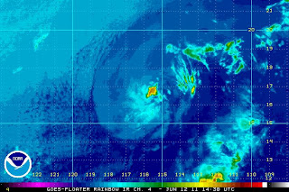
Adrian has weakened below Tropical Storm Status and doesn't even deserve to be that at this point. See the below infrared imagery.
Adrian is literally only a strong couple of storm cells wading in the ocean. Although you can still see the bands of energy surrounding the 'center' of Adrian, This storm cell will be fading shortly.
The NHC had some trouble recognizing Adrian as well, and decided to name it 'Unknown'.
This is the final bulletin of Adrian that will be issued.
Subscribe to:
Posts (Atom)


