Wednesday, February 29, 2012

Potential for Another Significant Severe Weather Event March 2


The SPC has outlined another very large area of potential severe weather for March 2nd, only continuing to signal that spring has indeed sprung.

Discussion-
A 30% chance of severe weather on the Day 3 forecast is very concerning in my eyes. Frankly, I worry that this may very well end up like today, especially with the way the slight risk is angled in comparison to what has evolved today.
The 12z NAM is printing EHI values conductive for tornadoes to once again start in Oklahoma and Arkansas before moving into Tennessee/Kentucky and Indiana. This does mean that the threat may be slightly further north. There should not be much of a cap over the area that could prevent storms, so any that do fire would easily break any cap that would be present, as per the 12z NAM. Instability should be edging up around 2000 j/kg, which combined with moderately high EHI values, could easily make for a dangerous situation.
An even more concerning piece is the available shear, with SFC (surface) to 700mb level shear exceeding 50 knots, which is fairly high- about as high as what was forecasted for today. Shearing closer to the surface appears to be less of an issue, which would be a good thing for those fearful of tornadoes.
Helicity in general, not accounting for instability, will be pretty high and will be something to watch.

The GFS also appears to indicate something will be firing, but because the GFS is not equipped with the same indices as the NAM, I cannot determine if the GFS sees the threat better or worse than the NAM.

This whole deal is pretty eerie, as a lot of similar features appear to be coming extremely similarly together as they have with today's severe weather outbreak. This will certainly be interesting.

Here's my long range look at the tornado threat.

Any questions can be asked below.
-Andrew

EF-4 Tornado Hits Harrisburg, Illinois **6 DEATHS**

The NWS has indicated that an EF-4 Tornado was confirmed in Illinois from the severe storms that started yesterday and continue through today.

**6 DEATHS HAVE BEEN CONFIRMED**


***preliminary information only... assessment ongoing***

The following is an initial report in... from a damage assessment
ongoing for the city of Harrisburg in southern Illinois.

* Event date - Wednesday February 29 2012

* event time - 456 am CST

* event type - preliminary EF4 tornado

* event location - southern part of Harrisburg

* peak wind - estimated 170 mph

* average path width - estimated 200 yards

* discussion/damage - strip mall near wal Mart suffered major
damage. Additional information regarding damage... injuries and
fatalities will be added to this preliminary report... as will
path length. As of right now... the latest is 6 deaths have been
reported.

This is considered a continuous update post and will be updated as more info comes in.

Law Enforcement Warning (Highway Closure)- Duluth, Minnesota


WIC003-010200- BULLETIN - EAS ACTIVATION REQUESTEDLAW ENFORCEMENT WARNINGMINNESOTA EMERGENCY MANAGEMENT AGENCY DULUTH MINNESOTARELAYED BY NATIONAL WEATHER SERVICE DULUTH MN306 PM CST WED FEB 29 2012 THE FOLLOWING MESSAGE IS TRANSMITTED AT THE REQUEST OF THEASHLAND COUNTY SHERIFFS DEPARTMENT. THIS IS AN URGENT MESSAGE FROM THE ASHLAND COUNTY 911COMMUNICATIONS CENTER. U.S. HIGHWAY 2 IS DECLARED IMPASSABLE AND CLOSED BETWEEN SANBORNAVENUE AND STATE HIGHWAY 13 NORTH DUE TO EXTREME WEATHERCONDITIONS. MOTORISTS ARE TO USE THE DESIGNATED STATE HIGHWAY 137DETOUR. THE CLOSURE WILL REMAIN IN EFFECT UNTIL FURTHER NOTICE.

Stearns, Kentucky TAKE COVER

This image depicts a possible tornado. If you are in Stearns, TAKE COVER!

Tornado Warning (Confirmed Tornado, Blown Transformers Seen)- PennyRile parkway, Kentucky


626 
WWUS53 KPAH 291245
SVSPAH

SEVERE WEATHER STATEMENT
NATIONAL WEATHER SERVICE PADUCAH KY
645 AM CST WED FEB 29 2012

KYC107-149-177-291300-
/O.CON.KPAH.TO.W.0022.000000T0000Z-120229T1300Z/
MCLEAN KY-MUHLENBERG KY-HOPKINS KY-
645 AM CST WED FEB 29 2012

...A TORNADO WARNING REMAINS IN EFFECT FOR CENTRAL HOPKINS AND
SOUTHEASTERN MCLEAN COUNTIES IN NORTHWEST KENTUCKY...AND NORTHERN
MUHLENBERG COUNTY IN SOUTH CENTRAL KENTUCKY UNTIL 700 AM CST...

AT 640 AM CST...TRAINED WEATHER SPOTTERS REPORTED A TORNADO CROSSING 
THE PENNYRILE PARKWAY AT EXIT 44. BLOWN TRANSFORMERS WERE ALSO BEING 
REPORTED. THE TORNADO WAS MOVING EAST AT 55 MPH.

PRECAUTIONARY/PREPAREDNESS ACTIONS...

TO REPEAT...A TORNADO IS ON THE GROUND. TAKE COVER NOW. MOVE TO AN
INTERIOR ROOM ON THE LOWEST FLOOR OF A STURDY BUILDING. AVOID
WINDOWS. IF IN A MOBILE HOME...A VEHICLE OR OUTDOORS...MOVE TO THE
CLOSEST SUBSTANTIAL SHELTER AND PROTECT YOURSELF FROM FLYING DEBRIS.

&&

LAT...LON 3715 8693 3725 8759 3742 8752 3744 8710
      3737 8709 3734 8713 3734 8710 3738 8708
      3737 8704 3735 8700 3727 8697 3726 8695
      3718 8689
TIME...MOT...LOC 1244Z 277DEG 48KT 3730 8740

$$

Tornado Warning (Tracking Confirmed Tornado)- Santa Claus, Indiana


336 
WWUS53 KPAH 291217
SVSPAH

SEVERE WEATHER STATEMENT
NATIONAL WEATHER SERVICE PADUCAH KY
617 AM CST WED FEB 29 2012


INC147-173-291230-
/O.CON.KPAH.TO.W.0019.000000T0000Z-120229T1230Z/
SPENCER IN-WARRICK IN-
617 AM CST WED FEB 29 2012

...A TORNADO WARNING REMAINS IN EFFECT FOR EAST CENTRAL WARRICK AND
NORTHERN SPENCER COUNTIES IN SOUTHWEST INDIANA UNTIL 630 AM CST...

AT 616 AM CST...NATIONAL WEATHER SERVICE DOPPLER RADAR WAS TRACKING A
CONFIRMED TORNADO.  THIS DANGEROUS STORM WAS LOCATED 8 MILES
SOUTHEAST OF FOLSOMVILLE...OR 10 MILES NORTH OF ROCKPORT...MOVING
EAST AT 65 MPH.

PRECAUTIONARY/PREPAREDNESS ACTIONS...

TAKE COVER NOW. MOVE TO AN INTERIOR ROOM ON THE LOWEST FLOOR OF A
STURDY BUILDING. AVOID WINDOWS. IF IN A MOBILE HOME...A VEHICLE OR
OUTDOORS...MOVE TO THE CLOSEST SUBSTANTIAL SHELTER AND PROTECT
YOURSELF FROM FLYING DEBRIS.

&&

LAT...LON 3799 8683 3797 8687 3792 8712 3810 8718
      3821 8689 3821 8680 3800 8678
TIME...MOT...LOC 1217Z 252DEG 57KT 3803 8708

$$

Tuesday, February 28, 2012

Tornado Warning- Hutchinson, Kansas


379 
WFUS53 KICT 290030
TORICT
KSC155-290100-
/O.NEW.KICT.TO.W.0001.120229T0030Z-120229T0100Z/

BULLETIN - EAS ACTIVATION REQUESTED
TORNADO WARNING
NATIONAL WEATHER SERVICE WICHITA KS
630 PM CST TUE FEB 28 2012

THE NATIONAL WEATHER SERVICE IN WICHITA HAS ISSUED A

* TORNADO WARNING FOR...
  EASTERN RENO COUNTY IN SOUTH CENTRAL KANSAS...

* UNTIL 700 PM CST

* AT 626 PM CST...NATIONAL WEATHER SERVICE METEOROLOGISTS WERE
  TRACKING A SEVERE THUNDERSTORM CAPABLE OF PRODUCING A TORNADO. THIS
  DANGEROUS STORM WAS LOCATED NEAR ARLINGTON...OR 15 MILES NORTH OF
  KINGMAN...AND MOVING NORTHEAST AT 60 MPH.

* LOCATIONS IMPACTED INCLUDE...
  HUTCHINSON...PARTRIDGE...SOUTH HUTCHINSON...BUHLER...YODER...
  WILLOWBROOK AND HUTCHINSON AIRPORT.

PRECAUTIONARY/PREPAREDNESS ACTIONS...

THIS TORNADO WARNING REPLACES THE SEVERE THUNDERSTORM WARNING THAT
WAS IN EFFECT FOR THE SAME AREA.

&&

LAT...LON 3817 9795 3817 9770 3813 9770 3796 9771
      3776 9813 3790 9828
TIME...MOT...LOC 0030Z 229DEG 53KT 3790 9811
HAIL 1.75IN

$$

Afternoon Prognosis

TERMS TO KNOW:
Hodograph: A device measuring distance from its starting point as the device ascends through the atmosphere on a weather balloon. Circular shapes can indicate rotation in the atmosphere.
EHI: A combination of spinning and helicity to make for, in my eyes, the best attempt to forecast where apt tornado conditions may be.
CAPE: Instability. Values above 1000 j/kg can be conductive for thunderstorms.

Prognosis--
SPC has lowered tornado threat and eliminated the 10% tornado risk. At the same time, the 5% tornado risk area has expanded north.
The main issue is that this tornado threat, in my eyes, may still be needed.

Latest 18z NAM is indicating high values of EHI (spinning+instability equation that can help determine a tornadic atmosphere) present on the Oklahoma Arkansas border. At that same time, storms should be just beginning to enter that area, with the 18z NAM projecting these storms to be fairly weak. However, this weakness is likely understated- At the point in time in question, the squall line will be not be a line yet, but it will be a weakly put together line of separate storm cells. Judging by forecast high EHI values and CAPE above 1000 j/kg, this should be an interesting night.

Here's a comparison for forecast hodographs of the 18z NAM (left) and the 12z GFS (right). While the models are on different runs, I have affixed them to be at the same forecast time.
The 18z NAM is honestly pretty concerning, with two roughly circular shapes present in the forecast. To start off with the whole hodograph is concerning, as the hodograph shows a half circle shape before suddenly turning into two tight bands of circles.  The sudden changeover to the circles makes me think that there may be too strong winds in the atmosphere to create a robust tornado, but that is dashed after the hodograph reveals the circular formations, both of which are likely indicative of a rotational motion in the atmosphere.
The 12z GFS is much more modest, having the hodograph take a similar half-circle-sudden-change path, but where the NAM shows the circles, the GFS shows it's attempt to make a circle, but believes that winds will be too tight for rotation to be shown. After that, the GFS hodograph shows it going off the screen but likely making a near full circle shape. Again, that is one of the more concerning features of this hodograph.

Midday Prognosis

12z NAM Is printing a scary scenario this evening with dangerously high Helicity (1st image) and EHI (2nd image). Again, EHI is the spinning in the atmosphere plus energy in the atmosphere. Values over 1 are dangerous.

Since this is done from my phone, the Helicity image is the one with pink in the image.

Update this afternoon.
Andrew

Severe Weather Prognosis (2/28/12)


As expected, the Storm Prediction Center did not issue a moderate risk for today, which in my eyes was a good move.
That does not, however, mean that the risk today will be zero. In reality, it is actually pretty substantial.
The first image is the overall outlook for severe storms in general. The second image indicates the chance for a tornado. I have come to learn that when there is a 10% chance of a tornado, a tornado can be reported in that 10% area. This time, however, that 10% area is so small that the chance of a tornado inside that 10% area seems lower than what it seems.

Prognosis-
A severe weather event is possible today in Arkansas, Missouri and west Tennessee, among other states. Forecast models indicate shearing levels between the surface and 700mb to be pretty sufficient on the GFS, with speeds of above 50 knots. However, this big shearing is in Missouri, with slightly lower speeds in Arkansas, thereby slightly reducing the tornado threat. Good shearing is also present in the surface-500mb area, but again, the big wind speeds are to the north and west of the main tornado risk put out by the SPC.

Precipitation should start this afternoon and congeal into something better than disorganized cells later in the afternoon/evening. An atmospheric cap will be over the area where storms break out, but it will be a very weak one, so these storms should easily break it.

An atmospheric cap is what's called CINH in the meteorology world. CINH is detected when a layer of warm air is present over the cooler atmospheric air up in the skies (warm air in the storms rises through the cool air over the atmosphere to make storm clouds and then storms.). If this CINH is too strong, the storms will be forced to stop at the 'cap' of warm air, as the air is too warm so the storms cannot continue rising through the atmosphere. This thereby 'caps' the storm and keeps it from getting stronger.

The tornado threat in Arkansas will be an overnight one, with maximum EHI (instability and spinning motion combined) values coming into the state at 3:00 AM CST. This is a very dangerous situation, as many will be asleep and not be able to hear a tornado coming. Additionally, tornadoes are much harder to be seen at night.

I will provide another update this afternoon. Stay safe everyone.
-Andrew

Monday, February 27, 2012

Prognosis on Feb. 28-29 Severe Weather Event

Prognosis--

Latest short range models I am seeing are developing a fair squall line starting tomorrow around 5:00 PM CST, with the squall one forming later in the evening. The line looks to be separate storm cells congealed into a weak line formation. This would be okay for supercell formation, but radar returns really are not impressive. Some strong storms certainly look possible from this, but a devastating event is not in the books here.
Just glancing at radar returns from the latest short range models tells me that the least held together storm cells look to be present in east Oklahoma into Kansas and Missouri. After that, the tornado threat looks to weaken in Arkansas as the storms turn more linear and less of individual cells.

Opinion on SPC Day 2 outlook...
The SPC appears to be accurately portraying this threat, but I am not thinking that a 'moderate risk' level is necessary for tomorrow. The way the NAM is playing out things tells me that Arkansas will probably not get anything in a moderate risk atmosphere, but if the SPC does decide it is necessary, I think it would be a low level moderate risk.
However, the NAM is having surface winds at over 20 MPH across the entire potentially affected area, leading the way for possible wind shearing which would easily make the way for the threat of tornadoes.

Sunday, February 26, 2012

February 28-29 Storm Discussion (2/26/12)

Prognosis-


Storm Prediction Center has issued a Slight Risk for severe weather on 'Day 3' (2 days away, because Day 1 is today, day 2 is tomorrow, etc.). This Slight Risk includes a 30% risk of severe weather in Arkansas, Southwest Missouri and East Oklahoma, with formidable risks still present in Northeast Texas and the rest of the aforementioned states.

A worry I have to start with is the tilt of the storm. Every storm has a tilt. There is a positive tilt, in which 500mb winds (seen above) will be strongest to the southwest of the system, or a negative tilt, where the strongest winds will be to the southeast of the system. This situation involves a negative tilt storm, and let me tell you why that is bad news.

Negative tilted troughs indicates that the storm has reached maturity and is at maximum strength. Additionally, negative tilted troughs will have cold air running over the warm air, which thus provides additional instability and makes for more severe thunderstorms.

These 500mb winds are also concerning, as the top wind speeds appear to be up to 110 knots, which equates to about 130 MPH. This raises the concern for wind shearing. With high winds at different height levels in the atmosphere, wind shearing can take place. This shearing makes the environment for tornadoes much more conductive than without shearing. Unfortunately, that appears to be what will be happening in this situation.

This is what's called a hodograph. Hodographs measure where the radiosonde is being taken by winds in the atmosphere, which are then used to tell if there is rotation in the atmosphere. A radiosonde is what is sent up in those big weather balloons by the National Weather Service. This hodograph is forecast for the time storms are to be present in Arkansas. This hodograph was based near Hughes, Arkansas.

In this hodograph, we see forecast strong lower level winds as the lines are very long from one number to the next. Notice how it begins to form a half circle shape, meaning that there is some form of rotation being detected at that point in Arkansas. Suddenly, the half circle stops and makes a full circle/square shape. This is exactly what no one wants to see.

What this complete shape means is that there is suddenly a very tight area of rotation in the atmosphere that could cause a tornado. No meteorologist ever wants to see that complete shape.

Moving on, the line then goes off the chart, but likely makes another half circle shape, again indicating some form of rotation may be present.

This hodograph tells us that there may be some tornadic activity in the area come February 28-29. I am concerned about that complete circle that was shown in the hodograph, and I believe that will be something to seriously watch.

The NAM is showing that there will be a lifting mechanism in place to get the storms going. This image portrays the Lifted Index, or LI. When the LI goes negative, it means that stronger storms are likely. When it is positive, it means that the atmosphere is more stable than not.

The Lifted Index here calculates to about -5 in Arkansas and Texas, which is some pretty good instability that could very well get those storms rocking.

The final index is the Energy Helicity Index (EHI). It calculates rotation + energy (CAPE) in the atmosphere to make one of the better indicators for potential tornadoes. Values over 1 are considered apt for tornadoes.

In this image, we see values of 1 to 1.25 in some scattered spots in Arkansas, leading me to believe that Arkansas will be where the strongest of storms happen and where the best chance for a tornado will be. I find it hard to believe that people in the Lower Great Lakes will get anything big out of this as there will be more limited moisture and atmospheric instability.

All in all, I suggest you keep a sharp eye on this. It could get interesting.

-Andrew

Saturday, February 25, 2012

Brief Look into Winter 2012-2013


Here are forecasted precipitation and temperature anomalies (respectfully) for DJF (December, January, February). These forecasts are from the Ensemble Canonical Correlation Analysis (ECCA) forecast system at the Climate Prediction Center.

For precipitation, the ECCA is projecting above normal precipitation across the northern US, but also majorly in the West US, where a 40% chance is present. For the North US, it looks like widespread areas of up to 10% are present. The same is present in the Northeast.

As for temperatures, it appears a major area of below normal temperatures are forecasted in the Plains, Midwest, Ohio Valley, South Plains, Southeast, Northwest, Southwest. The High Plains and Northeast are slightly above normal, though.

This is simply a look into next winter and not a forecast.

February 28-29 Storm Discussion

"Dynamic System Signals Spring's Commencement"

A dynamic system is poised to strike the US and bring everything from snow to possible tornadoes. Here's the latest:

Snowfall
The strong system that comes through will be cold on the north part, indicating that the event will be quite a snowy one. Accumulations at this point look to be pretty substantial, with this strong a system not keeping 12 inches+ out of the question. Then again, it is a bit too far out to forecast snowfall. Any snowfall should be wind driven, with this strong a system making for possible blizzard conditions in the Dakotas into Minnesota.

Severe Weather
There does look to be some severe weather possible with this system. Lower, middle, and upper level winds look to be pretty strong during this event, with 700mb winds possible reaching above 70 knots (80 MPH). A strong jet stream (over 130 knots (150 MPH) are possible) combined with a strong lower level jet stream (70 knots + possible) makes for a very potent tornado set-up in the spring and summer. However, it is late February. Thus comes the issue of lack of instability. Without instability and lifting mechanisms, it looks like this event will cause some possible brief spin-ups in north parts of the rain area, with some more potent rotation in the severe weather area.

Questions can be asked below.
-Andrew

Potential Severe Weather Event Feb. 28 (Issued 2/25/12)

Top left image: 700mb winds
Top right image: 300mb winds
Bottom left image: 850mb winds
Bottom right image: Precipitation
The set-up for severe weather continues to intensify with major wind speeds at heights that are monitored for tornado development. If winds at any of the 3 wind images are high, it usually indicates a risk for some spinning motion in the air which could then cause tornadoes.
What the GFS is currently showing is a few clusters of storms that would then evolve into a squall line. Squall lines are traditionally unfavorable for tornadoes as they are cells in a linear formation, like trying to have car wheels turning inside a box. It just doesn't work.

It looks like this level of wind shear would be favorable for some tornadic activity, but it is impossible to predict where tornadoes will occur. These are just guesses.

There is the issue on how there is virtually no CAPE, or instability, forecast for the storms to use. Additionally, the Lifted Index (lift) and CINH (Cap that stops instability) are next to nothing, if nothing. The non-presence of those indices pretty much cancels any potential of severe weather. However, the way that this is mapped out tells me that a brief, weak tornado is possible. Thunderstorms will be likely as this is a squall line when you come down to it.

Friday, February 24, 2012

Potential Severe Weather Event on February 28, 2012 (2/24/12)

I am closely watching the potential for some rare severe weather in the Midwest this upcoming Tuesday. Here's hour 114 of the 12z GFS.


Top left image: The top left image is 700mb wind speeds. The 700mb level is generally considered the area where 'jet streaks' (areas of strong winds within a jet stream) are found. Anyway, we see wind speeds of over to 70 knots, which equates to 80 MPH. 80 MPH is fairly strong for the 700mb level and can very well be conductive for severe weather. Seeing as this wind is flowing northeast, storms that form will be influenced and be moving northeast as well.

Top right image: The top right image is 300mb winds, which are the jet stream winds. In order for severe storms to form, there is usually a strong jet stream In this case, we have a jet stream of up to 130 knots present across a big swath of the Midwest, which equates to 150 MPH. 150 MPH is very strong and is nothing to mess with. To give you an idea of how strong it is, the jet stream present for the devastating April 27, 2011 tornado super outbreak was around 150 MPH.

Bottom left image: The bottom left image is 850mb winds. 850mb winds can detect how fast air flows, as the 850mb level is commonly watched for air temperatures at the surface. 850mb winds in this image show that wind speeds will be up to 70 knots+, which as shown above is over 80 MPH. Strong 850mb winds are usually pretty good for tornadic activity, so this will be something to watch.

Bottom right image: This is precipitation. In a couple images before this, the storms appear to form as a squall line turning into a cluster of storm cells. Multicelled storm clusters are typically the most dangerous and can be more conductive for tornadoes than squall lines. This will be something to closely watch.

We did pull up the best possible analogue picked out by the CIPS Analogue system, and here's what it has for severe weather reports from February 24, 2001.
As you can see, it was a pretty active day for severe weather, with 11 tornado reports, 99 wind reports and 59 hail reports. I can see this happening if it was moved north into the Midwest and Lower Great Lakes.

This could be a pretty serious event and will have to be watched.
Any questions can be asked below.
-Andrew

Long Range Forecast Update (2/24/12)

Prognosis- Just took a look at the 12z GFS. It's looking like the infamous Alaskan Vortex will be returning in a week or so. Until then, expect progressive storm systems and ridges until about a week, when a more solid pattern of a ridge should set up. Thus, some quieter weather is probably in the books in the future.
Personally, this looks to be it for winter. I am seeing some dynamic storm systems that may give the North Plains a good surprise for snow, but other than that, I can't say things are looking too positive.

Any questions can be asked below.
-Andrew

February 22-24 Snowfall Event Wrap-Up

Starting February 22, a strong 'Saskatchewan Screamer' system dropped from Canada and into the US. A Saskatchewan Screamer (SS) system is a storm system that forms in Saskatchewan, Canada, and quickly moves, or 'screams', through the US.

February 22, 2012 Surface Analysis at 03z
This is the surface analysis for 3z February 22, which is 9:00 PM CST February 21. We see the two parts of the storm- the Saskatchewan Screamer just northwest of North Dakota, and the storm system on the Oklahoma/Texas border. At this point, the storm is not of particular interest and not of particular strength.

February 22, 2012 Surface Analysis at 06z.

This is the surface analysis for midnight Feb. 22, CST. The Saskatchewan Screamer (which will now be referred to as System 1) is now racing into South Dakota with a central pressure of 998 millibars. At this point, it is of interest as the system is being strengthened by a jet stream that has winds at roughly 125 MPH. The jet stream of the 0z and 12z timeframes just before and after (respectively) of this surface analysis indicates that a strong trough had developed in the jet stream that had pushed it south. This trough in the jet stream tells me that its southward motion would continue, but the strength of the jet stream to the west would keep the southward movement also at an eastern movement, making for a southeast direction.
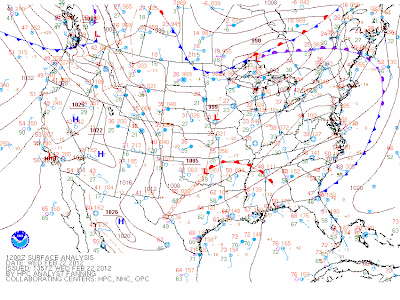
February 22, 2012 Surface Analysis at 12z
At 12z (6 AM CST), System 1 has now progressed into Iowa, keeping the main snows behind into the Dakotas. Central pressure indicates the system is at 999 millibars. Of more interest is System 2, now in Oklahoma. The central pressure is at 1005 millibars- not too strong. However, there is now a dry line in place that increases concern for severe thunderstorms. The presence of a warm front over what used to be a stationary front indicates that the warm air mass is now on the move and will now begin to displace other air masses, therefore instigating more thunderstorms along the front. Now, this would be a bigger concern if temperature differences were larger. Temperature readings (red numbers) north and south of the warm front are not too different from each other, thereby significantly lowering the severe weather threat.

After that, everything gets complicated as surface analysis maps do not clearly depict the system differences. However, it does come to point that the main snows begin to come back south towards the Lower Great Lakes.

February 23, 2012 Surface Analysis at 12z
A day later, the main system appears as a 989 millibar system. To watch now is the frontal system stretched from Kansas to West Virginia. Eventually, this cold front will turn into a warm front and move north as the 989mb system moves east into Missouri.

This warm front then becomes the focus for where snow will fall. Tight temperature gradients in the summer are typically the focus of thunderstorms. A temperature gradient is the difference of temperatures between points. This temperature gradient is also a good point for snowfall to occur in the winter. The gradient is also an area where snow banding sets up. This banding is typically where the heaviest of heavy snows fall.

In this situation, the temperature gradient (TG) appeared to set up in the northern half of Illinois. Yesterday afternoon, a line of precipitation moved north across northern Illinois. In areas of lighter precipitation, there was reported rain and a mix of precipitation. In the heaviest precipitation, very large snowflakes were reported to be falling. Accumulations of about an inch resulted.

In the aftermath of this band, it was mentioned by National Weather Service Chicago that this band of precipitation had indicated where the heaviest snow would fall overnight.
And that's where it became foggy.

The National Weather Service and RUC Short Range model were at odds. The RUC placed the heavier snows on the WI/IL border, while the NWS put Northeast Illinois in the heaviest snowfall. In the end, the RUC model won out.

Snowfall amounts were highest on the Wisconsin/Illinois border, where very isolated 8-10 inches were found. The National Weather Service became somewhat erratic in the first couple hours as the storm went on, with NWS Chicago suddenly lowering snowfall amounts and shifting the heaviest snowfall to right up against Lake Michigan.

The system then continued eastward with substantial strength. Again, the frontal positions were of issue, and snowfall amounts may have ended up slightly less than what is shown on here. The only reason that it is unsure is because the snow event is just ending.

If you have any reports, they would be appreciated below.
I am recovering from what may have turned out to be a brush with the flu and am feeling much better. Thanks to everyone who sent well wishes!

-Andrew

Thursday, February 23, 2012

Rain-to-Snow Changeover Earlier than Anticipated


Radar and observations are indicating that the changeover from rain to snow has happened. It was supposed to occur this evening, but now that it has changed over, I do anticipate snowfall accumulations to be higher than what is being shown on the models right now. In order for the models to recognize this unexpected changeover, I recommend not using the short range models until the 20z (2:00 PM CST) runs, which by then should have detected the early changeover.

Concerning Tornado Threat Present Today in North Kentucky

day1otlk_1300.gif
I am concerned about the tornado threat in North Kentucky today. The Storm Prediction Center has outlined Kentucky, Tennessee, north Georgia and north Alabama, South Ohio and South Indiana in a slight risk of severe thunderstorms.

WB013_JETSTREAM300_HOUR_K_6.png
The GFS's forecast of the jet stream shows the Southern Jet and main Mid Latitude jet stream trying to intersect in Oklahoma. Notice how both jet streams back away from each other in Kentucky. When jet streams are forced away from each other (they would have come together in Oklahoma and stayed together through the rest of the country), it indicates a massive rising of air. In other words, a lot of instability in the atmosphere. Diverging jet streams are usually seen in the Spring and Summer with more powerful storm systems.

day1probotlk_1300_torn.gif
The SPC outlines an alarming 10% risk of a tornado in north Kentucky. Now, the SPC outlines tornado risks at low levels because no one can predict a tornado. It is impossible. That said, I have come to learn that a 10% chance of a tornado outlined by the SPC usually results in a tornado in the outlined area.

A strong jet stream will not help matters. This strong jet stream will create a lot of turbulence in the region, meaning a more dynamic and unpredictable wind pattern that will likely become more conductive for rotation in the atmosphere.

NAM_218_2012022312_F06_36.0000N_87.0000W_HODO.png
Here is a hodograph. A hodograph is basically a tracer from the area it was released to the upper points of the atmosphere. A hodograph is attached to a radiosonde, which is the instrument sent up that is attached to those big weather balloons. Anyhow, when a hodograph comes back in a circular formation, it means that there is some form of rotation action occurring in the atmosphere. We can see a half circle shape in the lower parts of the atmosphere. (The height is characterized by the distance from the first point, which in this case appears to be the dot on the left half of the image.)


Snowstorm Now Aiming for Chicago, Detroit

Well this is a whole new ballgame now.

It was only yesterday I was discussing how the storm would probably drop a few inches in Chicago, with some more in Detroit. Now take a look at Intellicast's 48 hour Snowfall Forecast.
ord_048.jpg
So last night, it turns out the NWS Chicago office issued a winter storm watch due to a sudden increase in snowfall forecasts. The Chicago NWS office is calling for a bigger swath of 6+ inches than Intellicast, but their graphic system appears to be having problems right now.

The system itself really is a clipper system, but is a very strong one. Alberta Clippers, commonly shortened to be called Clippers, are weak, fast-moving storm systems that drop from Alberta Canada. The system is moisture starved. That, combined with the progressive speed, leaves the storm to put down a few inches in a typical situation.

Now, the extensive winter storm watch that had been covering east Iowa has been cancelled. I personally find it pretty crazy. Here's why.
Yesterday, every NWS office except Chicago's had put down a winter storm watch. Late last night, the NWS Chicago takes the bait and also issues a winter storm watch. Now, this morning, every nearby NWS office except for Chicago has canceled their winter storm watch.

We will keep you up-to-date as this sudden snowstorm begins to take shape.

Wednesday, February 22, 2012

12z ECMWF Shows Superstorm in East Coast- But Will it Happen?

12zeuro850mbTSLPUS192.gif
This is the 12z ECMWF at hour 192, displaying 850mb temperatures and sea level pressure. We can see a very strong storm system on the East Coast at hour 192. There is a lot of cold air in place over the entire Northeast so that significant (1 foot+) snow accumulations would be almost guaranteed.

But will it happen?

12zecmwfnao.gif

I say no. The same ECMWF model run that is showing this superstorm is also showing a major positive NAO (North Atlantic Oscillation). A positive NAO will essentially make a ridge that diverts any storms away from the East Coast. Just simply using that, it is easy to see why this ECMWF run is flawed.
Other than the NAO, The Pacific North American Pattern (PNA) will be in a raging negative phase, indicating the likelihood of a ridge in the East and storm systems in the West half of the country.

Clipper System to Bring Up to 9 Inches of Snow to Wisconsin

WB019_3HR_SNOWFALL_HOUR_E_13.png
The 12z NAM model is predicting a fairly strong clipper system hitting central Wisconsin in the next couple days. The image above shows 3 hour snowfall accumulations at 9:00 PM CST tomorrow. Up to 3 inches of snow in 3 hours is pretty much an inch of snow per hour, which is actually a pretty good rate.

WB019_SNOWFALL_CUM_HOUR_M_28.png
Total snow accumulations look to be up to 9 inches, with widespread amounts of 2 to 6 inches. Now, a local model that I glanced over did show snow accumulations of up to 4 inches coming in for the Chicago area.
It does indeed look like that the NAM model is too far north with this system after analyzing HPC-made forecasts.

That said, you can see the correct forecast by taking the snowfall strip, moving it south into central Illinois and central Iowa, and deducting 1-2 inches from all amounts as the NAM typically overestimates snowfall amounts by a couple inches.

-Andrew

Long Range Maps Indicative of Southeast Ridge Returning

Here we have a map for 11 days out made using past analogues of similar situations. What is shown here are 500mb height anomalies. In the Southeast, there is a fairly large red area, indicating that the infamous Southeast Ridge may be returning.

The Southeast Ridge is a ridge of high pressure that is infamous for diverting storm systems away from the East Coast. What I am seeing here is the likely end of winter for the East Coast with this possible Southeast Ridge re-emergence.

Storm systems diverted away from the East Coast usually hit the Ohio Valley and/or the Midwest and Lower Great Lakes.

This is indeed long range, but will be something to closely watch as this could have major implications going into the end of February and beginning of March.

-Andrew

Notice

Okay everyone, once again this cold is downing me with Round 2.
No posting for the rest of today- I feel like junk.

Have a good day.
-Andrew

Tuesday, February 21, 2012

ECMWF Printing Dicey Situation for East Coast

ecmwf_temp_pmsl_f168.gif

The ECMWF is printing a potentially dicey situation for the East Coast in a possible severe weather event scenario. What we have here is hour 168 of today's 12z ECMWF. It is considered long range, so don't get too hooked on it.

This storm system looks to be a pretty well organized system, with a warm sector in front of it, pulling up warm, unstable air from the South as shown by the brighter colors being pulled towards the center of the storm. Another side of the storm is the following cold air, shown by the cooler colors in the Great Lakes. As shown in the spring and summer, severe thunderstorms do happen when opposing air masses collide. However, luckily, it is not spring just yet.

ecmwf_850mb_rel_hum_f168.gif
Here is the relative humidity forecast for hour 168. Relative humidity (RH) values at the 850mb level, which is shown here, are usually indicative of precipitation at the ground when values are 80 or higher. Let's take a look at the area where the storm may affect people. Much of Canada and the Great Lakes are under a big swath of 90% and greater RH values. This would most likely be the snowier part of the storm system.

Of more interest is the RH values along the East Coast. The way the RH values are positioned in a diagonal line of sorts along the Coast makes me concerned that the ECMWF is looking at a squall line forming. This really would not surprise me, with the warm sector being pulled out ahead of the storm system. The good news is that these RH values are between 60% and 90%, meaning that confidence in this possible squall line is low. The ECMWF does not publicly distribute precipitation charts, so these RH charts are the next best thing.

An area of 90%+ RH values does exist to the east of Pennsylvania. That does appear to be a rain event, judging by the 850mb temperatures and the proximity to the storms center. Again using proximity, it does not look to be a huge severe weather event, but some storms are possible offshore, as this blob of higher RH may be the warm front pulling up the warm air ahead of the storm.

ecmwf_850mb_wind_f168.gif
Lastly, we have 850mb wind speeds at hour 168. Meteorologists use this to determine if tornadoes are possible. In areas of higher wind speeds, this tornado risk is increased. Looking at the map, we see widespread wind speeds of 30 knots to 40 knots onshore, which is pretty low in terms of severe weather potential. Using this without looking at other wind parameters which also have a say in possible tornadoes, tornadoes seem pretty unlikely in my opinion.

Offshore may be a different story. The warm sector out ahead of the possible storms combined with maximum wind speeds of 60 knots just offshore the Northeast region tells me that waterspouts are not out of the question. Waterspouts are basically tornadoes on water, but with a lot less strength but still with damage potential. It is somewhat rare to have waterspouts hit land after forming at sea, and even rarer to have those waterspouts continue on land.

All in all, this doesn't look like a huge severe weather event if it does happen. The ECMWF does appear to be hinting at a possible squall line, which would provide some concerns, but again, nothing too major.

-Andrew

6-9 Inches of Snow Possible for South Wisconsin

http://clients.customweather.com/plot_images/client_sites/WEATHERBELL/
NAM/WB019/final/WB019_SNOWFALL_CUM_HOUR_E_28.png
The 12z NAM is printing out 6 to 9 inches of snow in south central Wisconsin over the next 3 and a half days. This comes as the model projects a storm system to move through Southern Wisconsin and strengthen as it does so, with some additional, lower amounts coming from other small storm systems.

The main system in question will be a clipper system, meaning that little to no Gulf of Mexico moisture will be available to this storm. This provides some benefits and disadvantages. A big benefit includes the lessened risk of a dramatic rain/snow line, which thus cuts down on icing and also leaves more snow than rain. One of the bigger disadvantages, however, is how the strength of the system will be hindered due to the lack of Gulf moisture.

A caveat I am seeing with this storm is the presence of a low pressure area in the Southwest. The jet stream will be positioned to have little influence from the low pressure system. Influence meaning the jet stream being dragged south. And this is where the problems are. I see the potential that the models may be underestimating the jet stream's position, meaning that the jet may be farther south than what is being shown. This development would bring the system south and essentially do the same with snow amounts.

Any questions may be asked below.
-Andrew

Notice

This was brought up to me in a comment yesterday, and I decided to see if anyone was interested.

I am open to having your weather blog post an article here on The Weather Centre so you can get your name out. I am also open to posting on someone else's weather blog.

Again, this is just throwing it out there, but if you want to post something on here or have me post something on your blog, comment below with your blog address so we might be able to work something out.

I am also open to any possible joint sponsorships with other weather blogs.

-Andrew

Monday, February 20, 2012

Personal Spring 2012 Severe Weather Forecasts

Galena, Illinois
Tornado Risk: 20%
Hail Risk: 65%
Damaging Wind Risk: 75%
Severe Weather Outbreak Risk: 35%

Maple Park, Illinois
Tornado Risk: 20%
Hail Risk: 65%
Damaging Wind Risk: 70%
Severe Weather Outbreak Risk: 35%

Hamilton, Ontario
Tornado Risk: 10%
Hail Risk: 45%
Damaging Wind Risk: 65%
Severe Weather Outbreak Risk: 25%

Belvidere, Illinois
Tornado Risk: 20%
Hail Risk: 65%
Damaging Wind Risk: 75%
Severe Weather Outbreak Risk: 35%

Des Moines, Iowa
Tornado Risk: 30%
Hail Risk: 70%
Damaging Wind Risk: 75%
Severe Weather Outbreak Risk: 40%

Milan, Tennessee
Tornado Risk: 40%
Hail Risk: 80%
Damaging Wind Risk: 80%
Severe Weather Outbreak Risk: Up to 50%

Linden, Virginia
Tornado Risk: 15%
Hail Risk: 55%
Damaging Wind Risk: 70%
Severe Weather Outbreak Risk: 30%

Shady Spring, West Virginia
Tornado Risk: 15%
Hail Risk: 60%
Damaging Wind Risk: 70%
Severe Weather Outbreak Risk: 30%

Holmesville, Ohio
Tornado Risk: 35%
Hail Risk: 70%
Damaging Wind Risk: 75%
Severe Weather Outbreak Risk: 35%

Wappingers Falls, New York
Tornado Risk: 25%
Hail Risk: 65%
Damaging Wind Risk: 70%
Severe Weather Outbreak Risk: Up to 30%

Cincinnati, Ohio
Tornado Risk: 30%
Hail Risk: 70%
Damaging Wind Risk: About 75%
Severe Weather Outbreak Risk: Up to 35%

Toledo, Ohio
Tornado Risk: 30%
Hail Risk: 70%
Damaging Wind Risk: 75%
Severe Weather Outbreak Risk: Up to 35%

Homer, Michigan
Tornado Risk: Up to 30%
Hail Risk: 70%
Damaging Wind Risk: Up to 80%
Severe Weather Outbreak Risk: 30%

Valparaiso, Indiana
Tornado Risk: 30%
Hail Risk: 75%
Damaging Wind Risk: 75%
Severe Weather Outbreak Risk: Up to 35%

Senatobia, Mississippi
Tornado Risk: 50%
Hail Risk: 85%
Damaging Wind Risk: 90%
Severe Weather Outbreak Risk: 50%

Grand Rapids, Michigan
Tornado Risk: 30%
Hail Risk: 75%
Damaging Wind Risk: 80%
Severe Weather Outbreak Risk: 30%

Kansas City, Missouri
Tornado Risk: 40%
Hail Risk: 80%
Damaging Wind Risk: 80%
Severe Weather Outbreak Risk: Up to 40%

Atlanta, Georgia
Tornado Risk: 45%
Hail Risk: 85%
Damaging Wind Risk: Up to 90%
Severe Weather Outbreak Risk: 45%

Detroit, Michigan
Tornado Risk: 35%
Hail Risk: 70%
Damaging Wind Risk: 70%
Severe Weather Outbreak Risk: 35%

Fort Wayne, Indiana
Tornado Risk: Up to 40%
Hail Risk: 75%
Damaging Wind Risk: 80%
Severe Weather Outbreak Risk: 40%

Antwerp, Ohio
Tornado Risk: 40%
Hail Risk: 75%
Damaging Wind Risk: 80%
Severe Weather Outbreak Risk: 40%

Philadelphia, Pennsylvania
Tornado Risk: 35%
Hail Risk: 65%
Damaging Wind Risk: 65%
Severe Weather Outbreak Risk: 30%

Sterling, Illinois
Tornado Risk: 40%
Hail Risk: Up to 75%
Damaging Wind Risk: 75%
Severe Weather Outbreak Risk: 35%

Brighton, Michigan
Tornado Risk: 35%
Hail Risk: 70%
Damaging Wind Risk: 70%
Severe Weather Outbreak Risk: 35%

Mt. Shasta, California*
Tornado Risk: 10%
Hail Risk: 55%
Damaging Wind Risk: 65%
Severe Weather Outbreak Risk: 10%
*Mountain severe weather is much harder to predict, so take this with a grain of salt.

Manhattan, Kansas
Tornado Risk: 55%
Hail Risk: 90%
Damaging Wind Risk: 95%
Severe Weather Outbreak Risk: Up to 60%

Bethel, Connecticut
Tornado Risk: 25%
Hail Risk: 50%
Damaging Wind Risk: Up to 60%
Severe Weather Outbreak Risk: 20%

These are all estimates based on historical severe weather and ENSO conditions.

GFS Depicting Strong Early March Storm System

http://clients.customweather.com/plot_images/client_sites/WEATHERBELL/
GFS/final_WB013/WB013_MSLP_RADAR_HOUR_M_82.png
The GFS is showing the potential for a major snow maker for the upper Midwest as well as a possible severe weather event in the Southeast to kick off March. It appears that the GFS is indicating this system will strengthen to 992mb in Colorado before sliding eastward and strengthening even more, this time with warm Gulf of Mexico air feeding in. This Gulf of Mexico air feeding in would enhance the potential for severe weather in the South, which already seems likely given the initial strength of the storm itself.

Because this storm is next month, don't bank on it. The GFS is notorious for showing long range storms that never come to fruition. Additionally, any forecast beyond 7 days should not be trusted. This is throwing out the idea that something could happen. It has been shown that, while this solution may not work out like shown, the model may be onto the general idea of a storm system in this timeframe.

Snowfall accumulations, if this did happen, would be pretty substantial, to say the least. A strong storm system combined with an open Gulf of Mexico makes for very ample conditions for dynamic weather events like thundersnow or tornadoes in severe weather. I cannot predict tornadoes or thundersnow, but that's just an idea of how a strong system and warm Gulf air can pair up.

-Andrew

Sunday, February 19, 2012

Spring/Summer 2012 ENSO Forecast

Hello everyone. The last 2 days have been dedicated to resting off one of my semi-annual colds, and it looks like i'm on the back end of it at this point. That said, I think it's time for the spring/summer 2012 ENSO forecast to be released.
This post will deal with several models and subsequent examinations of each model.

ECHAMA Model

ECHAMF Model
These are the ECHAMA and ECMAMF models, respectively. They are both based off of ECMWF forecasts which have been re-designated as climate models. I chose these two first as their ensemble members, first off come from the ECMWF and second, are the closest together of the bunch of other ENSO models.
The two ECHAM models are forecasting the Nino areas warming into a neutral phase by April, transitioning into an El Nino in June. I agree with this, as it is typical for the ENSO monitoring regions to warm in Spring and Summer. While the models do show the El Nino starting to fade going into September, I cannot say I am too inclined to believe that. This spring and summer may be a big warming that initiates the El Nino, but it is very possible that this warming keeps the El Nino into winter. It will either be an El Nino or neutral  phase.
Ensemble Forecast for ENSO
The models put together paint a rough consensus of what should happen going into spring and summer. All of the models are agreeing that this La Nina will be fading into summer, but that's when the consensus stops. From there, the infamous CFS v1 and CFS v2 models keep the ENSO at neutral conditions for summer into fall, while the other, more accurate models are going for a neutral/El Nino solution.
We meteorologists use something called 'skill maps' when there are several models like this giving different solutions. A skill map basically outlines areas where the models have higher confidence than other areas. Using a skill map on the ECHAM models shows that the ECHAM models are fairly confident in a neutral/El Nino solution for spring/summer, while the CFSv1 is very insecure on a solution. Its next generation, CFS v2, is more confident in its solution than the CFS v1.

So let's say there is a weak El Nino into this winter (which seems like the likely option of an El Nino were to persist through fall). Here is what the precipitation anomalies would look like based on historical events of weak El Ninos.
This would feature below normal precipitation anomalies in the Midwest and parts of the Appalachian Mountain region, with above normal precipitation anomalies on the entire East Coast. This mainly tells me that a Weak El Nino increases the number of Nor'easter's for the East Coast.


Here's weak El Nino temperatures, which is basically a cool down of the entire eastern half of the US. Again, this is what would happen historically, which hasn't always verified, as Mother Nature has shown this winter. This image of below normal temperatures implies to me that there are constant arctic shots of cold air into the eastern US.

So what am I thinking?
I am feeling pretty confident that the traditional spring/summer warm up of the ENSO region will make for a very weak El Nino in summer/fall. I am also going to say that this El Nino will likely peak mid-late summer and start to move towards the neutral ENSO phase going into winter. The question is if the El Nino will prevail this upcoming winter or weaken into a neutral phase. That I cannot answer- these are just my ideas for spring/summer into fall.

Any questions can be asked below.
Remember, personal spring severe weather forecasts will be issued tomorrow!
-Andrew

(credits for weak El Nino historical temp/precip: Data originally from ESRL, image from GGWeather)