Saturday, June 4, 2011

June 4- Tornado Warning- Walnut Creek, OH


* TORNADO WARNING FOR...
  SOUTHEASTERN HOLMES COUNTY 
IN NORTHEAST OHIO

* UNTIL 1000 PM EDT

* AT 916 PM EDT...NATIONAL WEATHER 
SERVICE DOPPLER RADAR INDICATED A
  SEVERE THUNDERSTORM CAPABLE OF 
PRODUCING A TORNADO. THIS DANGEROUS
  STORM WAS LOCATED NEAR 
MILLERSBURG...AND MOVING SOUTHEAST AT 25
  MPH.

* LOCATIONS IMPACTED INCLUDE...
  WALNUT CREEK...
  FARMERSTOWN...

June 4- Tornado Warning (Tornado Reported)- Hathaway, LA


THE NATIONAL WEATHER SERVICE IN LAKE 
CHARLES HAS ISSUED A

* TORNADO WARNING FOR...
  NORTHEASTERN JEFFERSON DAVIS 
PARISH IN SOUTHWEST LOUISIANA...
  THIS INCLUDES ELTON...

* UNTIL 830 PM CDT

* AT 757 PM CDT...LOCAL LAW 
ENFORCEMENT REPORTED A TORNADO NEAR
  ELTON...MOVING WEST AT 15 MPH.

* THE TORNADO WILL BE NEAR...
  HATHAWAY BY 810 PM CDT...

PRECAUTIONARY/PREPAREDNESS ACTIONS...

NATIONAL WEATHER SERVICE RADAR
INDICATES A TORNADO MAY FORM AT ANY
TIME. TAKE COVER NOW! ABANDON 
MOBILE HOMES AND VEHICLES. MOVE TO AN
INTERIOR ROOM OR HALLWAY ON THE 
LOWEST FLOOR AWAY FROM WINDOWS.

&&

PLEASE REPORT SEVERE WEATHER TO 
THE NATIONAL WEATHER SERVICE AT
337-477-5285 EXTENSION 1.

June 4- Tornado Warning (Tornado Indicated)- Newton, OH


...A TORNADO WARNING REMAINS 
IN EFFECT UNTIL 800 PM EDT FOR
TUSCARAWAS AND HARRISON COUNTIES...

AT 735 PM EDT...NATIONAL WEATHER 
SERVICE DOPPLER RADAR CONTINUED TO
INDICATE A TORNADO.  THIS TORNADO
WAS LOCATED NEAR NEWPORT...MOVING
SOUTHEAST AT 25 MPH.

* OTHER LOCATIONS IN THE 
WARNING INCLUDE BUT ARE NOT LIMITED TO
  UHRICHSVILLE...       
NEW PHILADELPHIA...   GNADENHUTTEN...
  DENNISON...           
GILMORE...            TAPPAN...

June 4- Severe Weather Emergency (Mass Population at Risk)- Rushville, IL


...A SEVERE THUNDERSTORM 
WARNING REMAINS IN EFFECT FOR SCHUYLER
COUNTY UNTIL 645 PM CDT...

AT 627 PM CDT...NATIONAL WEATHER 
SERVICE METEOROLOGISTS DETECTED A
SEVERE THUNDERSTORM CAPABLE OF 
PRODUCING GOLF BALL SIZE HAIL...AND
DAMAGING WINDS IN EXCESS OF 60 MPH.
THIS STORM WAS LOCATED NEAR
LITTLETON...OR 6 MILES NORTHWEST OF
RUSHVILLE...MOVING EAST AT 30
MPH.

LOCATIONS IMPACTED INCLUDE...
  RUSHVILLE AND RAY.

THOSE ATTENDING THE EVENT AT THE SCHUYLER COUNTY FAIRGROUNDS NORTH
OF RUSHVILLE ARE IN THE PATH OF THIS STORM AND SHOULD PREPARE FOR
DANGEROUS WEATHER CONDITIONS.

June 4- Tornado Warning- New Philadelphia, OH


* TORNADO WARNING FOR...
  NORTHWESTERN HARRISON 
COUNTY IN EAST CENTRAL OHIO...
  TUSCARAWAS COUNTY IN 
EAST CENTRAL OHIO...
  SOUTHWESTERN CARROLL COUNTY 
IN EAST CENTRAL OHIO...

* UNTIL 800 PM EDT

* AT 712 PM EDT...NATIONAL WEATHER 
SERVICE DOPPLER RADAR INDICATED A
  SEVERE THUNDERSTORM CAPABLE OF 
PRODUCING A TORNADO NEAR NEW
  PHILADELPHIA...MOVING SOUTHEAST AT 25 MPH.

* OTHER LOCATIONS IN THE WARNING 
INCLUDE BUT ARE NOT LIMITED TO   NEW
  PHILADELPHIA...   DOVER...              
GNADENHUTTEN...
  UHRICHSVILLE...       
DENNISON...           GILMORE...
  TAPPAN...

June 4- Tornado Warning (Rotation Detected)- Brewster, OH


...A TORNADO WARNING REMAINS IN 
EFFECT UNTIL 700 PM EDT FOR SOUTHERN
STARK COUNTY...

AT 631 PM EDT...NATIONAL WEATHER 
SERVICE DOPPLER RADAR CONTINUED TO
INDICATE A THUNDERSTORM WITH 
ROTATION ACROSS SOUTHWESTERN STARK
COUNTY. THIS THUNDERSTORM WAS 
LOCATED NEAR BREWSTER...OR 14 MILES
NORTHWEST OF DOVER...MOVING SOUTHEAST AT 30 MPH.

LOCATIONS NEAR THE PATH OF 
THE POSSIBLE TORNADO INCLUDE...EAST
SPARTA...MAGNOLIA AND WAYNESBURG.

NORTH OF THE ROTATION NEAR 
MASSILLON THERE HAVE BEEN SEVERAL REPORTS
OF GOLFBALL SIZE HAIL. THIS 
LARGER HAIL MAY MOVE ACROSS EAST SPARTA
AND NAVARRE.

June 4- Evening Tropical Cyclone Discussion- East Pacific Ocean

There is a 30% chance for tropical cyclone development in the East Pacific.
A system to the west of Central America is catching eyes and concerns from The Weather Centre.
Environmental conditions appear to be conductive for development in the next few days.
For this system's track, it appears there is a consensus for this storm to drift northwest out to sea. One wayward model flings the storm at Mexico, but as of right now I will not believe that. As the storm drifts away to the northwest, there should not be any interference over the next 5 days at least.
The worrying part is the potential intensity of this storm. All models take this system into at least a tropical storm strength. All but one model take the storm into high Category 1 strength to low Category 2 strength. That said, I believe there is a good consensus for the storm to drift out to sea, and also strengthen into a hurricane as of right now.

We will continue posting as needed, and may issue special updates on this system as needed.

June 4- Evening Tropical Cyclone Discussion- Atlantic Ocean

This is a special update that will account for tonight's discussion.
There is a 30% chance of development for a storm system located off the coast of South America. Upper level winds are beginning to decrease and aid in development. However, there is dry air pumping into the system, limiting the development process.
The tracks have changed a considerable degree. There is no longer a bigger consensus for the system to go out to sea, and there is more of a consensus for this system to go towards the Gulf of Mexico. Another option is for the storm to run up the East Coast. However, it depends on the intensity of this system to see if we should actually care about it.
As of right now, the ensembles prefer a non-tropical cyclone storm system into the next 5 days. The one model that goes beyond 120 hours also keeps the storm below tropical storm limits.

As of right now, it looks like the system could drift towards the US through the Gulf of Mexico, but shouldn't develop into anything major in the short term forecasts.

June 4- Tornado Warning: Canton, OH


THE NATIONAL WEATHER SERVICE 
IN CLEVELAND HAS ISSUED A

* TORNADO WARNING FOR...
  SOUTHWESTERN STARK COUNTY IN NORTHEAST OHIO

* UNTIL 700 PM EDT

* AT 555 PM EDT...NATIONAL WEATHER 
SERVICE DOPPLER RADAR INDICATED A
  SEVERE THUNDERSTORM CAPABLE OF 
PRODUCING A TORNADO. THIS DANGEROUS
  STORM WAS LOCATED NEAR 
MASSILLON...OR 12 MILES WEST OF CANTON...AND
  MOVING SOUTHEAST AT 15 MPH.

* LOCATIONS IMPACTED INCLUDE...
  MASSILLON...
  NAVARRE...
  PERRY HEIGHTS...
  HILLS AND DALES...
  MEYERS LAKE...
  CANTON...
  EAST SPARTA...
  WAYNESBURG...
  MAGNOLIA...
  EAST CANTON...

June 4- Tornado Warning: Kouts, IN


THE NATIONAL WEATHER SERVICE 
IN CHICAGO HAS ISSUED A

* TORNADO WARNING FOR...
  NORTHEASTERN JASPER COUNTY...
  SOUTHERN PORTER COUNTY...

* UNTIL 515 PM CDT

* AT 446 PM...NATIONAL WEATHER 
SERVICE DOPPLER RADAR INDICATED A
  SEVERE THUNDERSTORM CAPABLE 
OF PRODUCING A TORNADO. THIS DANGEROUS
  STORM WAS LOCATED NEAR HEBRON...
AND MOVING EAST AT 55 MPH.

* THIS TORNADIC STORM
WILL BE NEAR...
  KOUTS AROUND 455 PM.
  DUNNS BRIDGE AROUND 500 PM.

June 4- HRRR displays exploding storms in North IL

We bring you this special update from The Weather Centre concerning today's thunderstorms.
This is an hour by hour analysis of these storms as the initiate and move through the West Great Lakes. We are here to focus on North Illinois in this post.
1:00 PM, CDT
The above image is fresh off this model. It is painting the picture for initiation to occur at 1pm CDT in far east Iowa as a small cluster of showers and maybe an embedded thunderstorm. As of right now in that picture, there is an opportunity for some rotation because they are not in linear form yet.

2:00 PM CDT
At 2 pm, these storms will begin to move eastward and begin to organize themselves into a cluster of severe storms. At this point in time, it can be expected that these storms will be reaching strong to severe limits, with 50+ dbz (the color red) showing up on the radar.

3:00 PM CDT
By now at 3 pm, the storms are more organized and are blossoming as the enter North Central Illinois. At this point it is concerning because values of over 60 dbz (apricot on radar) are showing up in North Central IL. That is a very high radar reflectivity number to deal with. It can be expected that storms in that range will reach severe limits easily.

4:00 PM CDT
It is now 4:00 pm. Storms continue to explode around the organized cluster as they enter the Chicago area. These storms remain at dangerously high dbz levels on radar and will be producing severe weather. 

5:00 PM CDT 
The storms are now exiting the Chicagoland area and moving eastward. They remain very strong and are bowing out. This raises concern for a derecho, or long-lived wind event. It can be expected the potential of tornadoes will briefly rise inside this bowing structure, and damaging wind threats will skyrocket.

This has been a special briefing from The Weather Centre. We remain online before, during and after these storms move through.

June 4- Tropical Cyclone Morning Discussion

There is a storm system near Central America that has a 30% chance of tropical cyclone formation over the next couple days. Upper level winds are beginning to die off, providing a window of opportunity for this system to get its act together. While the system is currently stationary, it will be moving in the next 5 days.
The model ensembles only got a grip on this system yesterday and are very wayward in their guesses. As of right now, some models throw it out to sea, some models throw it towards the Gulf of Mexico, and some just keep it stationary. As of right now, it's anyone's game. There is a 3 model consensus of the storm going out to the Atlantic Ocean, and a 2 model consensus of the storm going towards the Gulf. I believe that one of those tracks will be somewhat right and the other will be dead wrong. However, my beliefs on this will change with each new model run in.
As for intensity forecasts, the models are fiddling around with this system, too. However, a slight consensus has formed to keep the storms winds between 20 knots and 55 knots over the next 5 days. It does appear that the simple majority of models want the system to become a tropical storm and stay that way for a couple of days. We will just have to see.

We will be watching this system closely, and will notify you if any changes arise throughout the day.

June 4 Severe Weather Discussion Forecast

Slight Risk area (Lower and East Great Lakes into Central/Upper Plains...

A cold front currently extends from Central Wisconsin SW into Central Iowa and into Kansas. This cold front is connected to a low pressure system currently located in Southwest Kansas. Just out ahead of the cold front is a warm front. This warm front reaches from the west border of Lake Michigan vertically down through East Illinois. Both of these fronts eventually connect into an occluded front in the Upper portion of Michigan (not the 'glove').
All of this is related to a very intense low pressure system in Canada. This intense low will move east and drag along the fronts. However, the much weaker low earlier mentioned in southwest Kansas will remain stationary. As a result, the cold front connected to that now stationary low will flatten out horizontally across the US. This will create the scene for severe weather.
The short range model RUC displays the cold front moving through with showers and embedded thunderstorms. However, the RUC puts out a small line of intense thunderstorms affecting Northeast Illinois only. A very localized string of strong/severe storms. This small line would be forecast to reach Northeast Illinois at 3pm CDT as of the latest forecast.
The Rapid Refresh short range model is also on board with this solution but may be slightly faster, with the storms possibly already impacting the area by 3pm CDT.
The main concern with these storms will be damaging winds and hail. The tornado threat is actually very low at this point, and I will disregard that concern for tornadoes. However, it does look like damaging winds is a good bet along with hail for primary threats.
Today's Hail threat

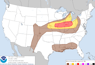
Today's damaging wind threat

Today's Tornado threat