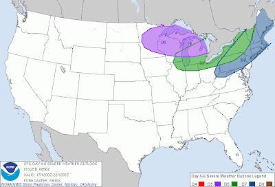
The Storm Prediction Center has outlined three areas of interest in its long range severe weather outlook. Each day is represented by a different color outline and abbreviation; D5 indicates the risk for 4 days out from today will be in that area, D6 indicates 5 days from this day will see the outlined severe weather risk, and D7 means the area outlined in dark blue will see its shot at severe weather in 6 days. The purple area will see severe weather on Thursday, the green area on Friday, and the dark blue area on Saturday. We will break down each day below.
Thursday Severe Weather Risk - Upper Midwest, Great Lakes
Thursday will see the start of this multi-day severe weather event. Surface forecast charts from the Weather Prediction Center show low pressure approaching the region, attached to a warm front/stationary front extending from Minnesota into the central Great Lakes. With a very hot, humid air mass in place as this low pressure system comes through, convective development is expected to begin along the frontal boundary. The first storms, barring any significant changes in coming days to forecast materials, should be individual cells that are hail producers. Any gust fronts or outflow boundaries produced by these first storms may easily fire off other cells in the Wisconsin/Michigan area that will continue to kick start the evening's severe weather activities. Composite reflectivity forecasts to not extend into this time frame just yet, so we will have to believe that these first storms that fire up may very well feed off the excitable atmosphere and quickly become severe.
Friday Severe Weather Risk - Great Lakes, Northeast
On Friday, the severe weather threat shifts east. WPC surface analysis charts see this day evolving with a low pressure system pulling a stationary front east, as a cold front bears down from Canada. Outflow boundaries produced by the thunderstorms on Thursday may very well extend into the Great Lakes and become focal points for thunderstorm initiation. The stationary front behind the low pressure system should act as another area where the first thunderstorms may very well initiate, and it could very well be this reason that the Storm Prediction Center has areas as far west as Chicago in Friday's risk area. As storms fire from the stationary front, it looks like the low pressure system will have a bit of that frontal boundary out ahead of it, which could cover the Great Lakes for thunderstorm development. The cold front pushing down from Canada would then likely provide the ignition for storms in a very hot and humid environment in the Northeast.
Saturday Severe Weather Risk - Northeast, New England
Saturday's situation is a bit less certain than the other two days. The reason for this uncertainty is shown in the WPC forecast graphic above- the cold front from Canada is shown having already pushed through the areas outlined for severe weather that day. Both the Storm Prediction Center and Weather Prediction Center charts will change, but due to the uncertainty at this point, I am not willing to elaborate on this day's set-up.
Andrew


