Sunday, July 8, 2012

Tropical Storm Emilia Forms in East Pacific

Tropical Storm Emilia has formed in the Eastern Pacific, with a central pressure of 997 millibars and maximum wind speeds of 65 MPH.

Emilia is forecasted by the National Hurricane Center to move on a west-northwest track, posing no threat to land. Emilia is forecast to strengthen rapidly over the next few days, with major hurricane status being shown in the morning hours of Tuesday. Whether or not this verifies remains to be seen.

Satellite imagery of Emilia indicates that the western flank of the system is wrapping into the storm, with a very defined circulation becoming apparent. A hurricane declaration on this system could very well happen soon, as the circulation enhances and convection looks to be enhancing on all sides, especially on the western side of the tropical system.

Andrew

Hurricane Daniel on Steady West Track

Hurricane Daniel is currently spinning in the East Pacific, where it is now a Category 2 hurricane. Earlier, Daniel had been a major hurricane for a brief period, reaching Category 3 strength.

Daniel's track takes the system on a straight westward course, possibly towards Hawaii over the next few days. However, over those few days, significant weakening is expected as the system moves in to less favorable waters for tropical systems.

Andrew

State of The Atmosphere - Winter Analysis - July 8, 2012

This is a look at the state of the atmosphere in relation to what effects the mentioned indices may have on the upcoming winter. This is not a forecast, but is more of a general how's-it-going analysis.

Southern Oscillation Index (SOI)
The SOI, in short, can be used as another indicator to what phase the El Nino-Southern Oscillation (ENSO) is in- an El Nino or La Nina. Values above 8 are used to define a La Nina, and values below 8 on the SOI can suggest an El Nino is present.
Currently, the 30 day average for the SOI is at -12, which would indicate El Nino conditions are present. Should the SOI continue to stay below the -8 mark, the likelihood will increase for a full-blown El Nino to be recognized.


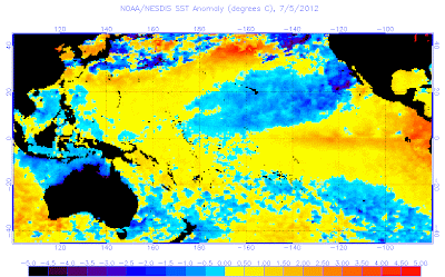
The latest sea surface temperatures across the equatorial Pacific do indicate that an east based El Nino appears to be in progress at this point in time. Temperature anomalies are reaching beyond 1 degree above normal in Nino 1+2, with more moderate anomalies in the Nino 3 and Nino 3.4 regions.
Recent indications are for these warm anomalies to be moving west with time, which could eventually translate into a west-based or (slightly more likely) central based El Nino. 

Summary
The atmosphere is primed for an El Nino, and sea surface temperatures are also looking favorable for El Nino conditions.

I was going to post more, but I feel that the rest will be left alone until fall, when the first official winter forecast comes out.

Andrew

Over 2000 Record High Temperatures Set Last Week

Image made by hamweather
http://mapcenter.hamweather.com/records/7day/us.html?c=maxtemp
Over 2000 temperature records have been set in the past 7 days, with the map above showing the majority of these records set in the lower Great Lakes and general Eastern US.

When it came down to it, 2103 separate high temperature records were set in the Lower 48 in the last 7 days, thanks to a historical high pressure system that pumped triple digit temperatures as far north as Chicago (IL), which experienced three consecutive days of 100+ degree temperatures.

An interesting fact: A quarter of the past week's records were set in the past 2 days.

Andrew