Tuesday, June 5, 2012

Venus Transit in Progress

Imagery from NASA and NOAA indicate that Venus is indeed beginning the famous 'Venus Transit' across the skies of the US. The next time this will happen does appear to fall in December, 2117, so this is very much a once in a lifetime event.

Remember!
Never look directly into the sun. There are several other ways you can view this historic event without directly looking at the sun.
Never look into the sun with a telescope. Doing that will only maximize eye damage.

GFS Seriously Misinterpreting System That Will Produce Weekend Severe Weather

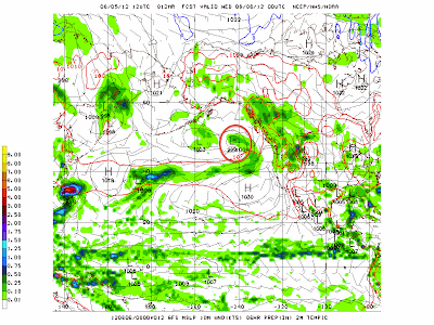
The GFS model is severely underestimating the strength of the storm system currently offshore that looks to either contribute or make up the strength of the system that will produce outbreaks of severe weather across the Northern Plains. Below shows the northern Pacific scene, valid at 7:00 PM CDT this evening.


The system we are watching I have circled in red. The 12z GFS clocks it at 999 millibars. Now, look below at the latest analysis from the Ocean Prediction Center, valid at 1:00 PM CDT this afternoon.

Here, the analysis of the system is at 995 millibars- 4 millibars lower than what the GFS is proposing. What this indicates is that the GFS appears to be underestimating the scope of the event.

Here is what will happen tomorrow.

-There will be no morning post.
-Around 1:30 PM CDT, I will be issuing a post concerning this multi-day severe weather event. When I issue this post, I will accompany it with a discussion that will take into account verification, much like I have shown above, in order to enhance my forecast.

Andrew

Offshore Disturbance will Ignite Severe Weather this Weekend

There is a strong low pressure system to the west of Canada, characterized by the counterclockwise rotation in place over the northeast Pacific. Farther south, there is a large swath of clouds and likely some precipitation that appears to have lost contact with the system itself and it now heading for the Northwest.

With a strong low pressure pushing east across the northern Pacific, this system being looked at will be pushed south and east, crashing into the Northwest US/Southwest Canada region before firing up intense thunderstorms in the northern Plains this weekend.

Multi-Day Severe Weather Threat Extended into North Great Lakes

The Storm Prediction Center has outlined another area in the northern Great Lakes to make 3 days worth of severe weather threats for the extreme northern US.

Days 5 and 6 were slightly retracted due to models showing increased capping, which, in strong amounts, can prevent storms from forming. It looks like the stability will be most prevalent in the early morning hours of each day, as the nighttime has cooled and stabilized the air. However, there will still be over 5000 jkg of instability waiting in eastern North Dakota by afternoon, so storms should be able to break that cap.
The northern Great Lakes situation could get interesting, because there will be a still large but weaker area of 3000 j/kg of instability for storms. The cap will still be forcefully returning during the night, so this particular threat area may be at risk for being too capped.

Andrew