Wednesday, June 26, 2013

Energy Moving off African Coast May Spark Tropical Interest

Two major global models are now indicating a piece of energy will move off the African coast in the next week or two that may provoke a tropical concern later on in July.

The above image shows the ECMWF model and GFS model forecasting lower level winds over the Atlantic Basin for 10 days out. Looking towards the African Coast, we see elevated values off the coast of Africa on both models. While the ECMWF model is considerably weaker with this piece of energy, it is apparent that there is interest in the long range models for the tropical wave train off of Africa to get going rather soon.

While this is a rather long range forecast, I would not doubt the development of a tropical system beginning in the next 10-14 days. We are entering the prime time for hurricane development; while it will not arrive until the fall months, summer is certainly a season that needs to be watched for hurricane development.

Andrew

Monday, June 24, 2013

Severe Weather Possible Tomorrow, June 25th

First off, for those of you wondering, the blog has been quiet in the last few days as I have made significant progress on over half of the 34 winter forecasts I will be issuing this late September or early October. I will have limited time around then, so it was best to do the work now.


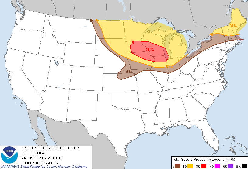
The Storm Prediction Center is indicating there is potential for a higher end severe weather event tomorrow. Shown above is the probability of severe weather within 25 miles of any given point. While the yellow and red areas are encompassed in the same slight risk area, the red area has a higher chance of seeing severe weather than the regions highlighted in yellow.

Model forecasts project the development of severe weather in the red area beginning tomorrow afternoon and continuing into the evening hours. While the resolution on simulated reflectivity forecasts is low, the general premise of a damaging wind/hail event is present in portions of the 30% area, while the western portion of the red area may be the spot for more isolated cells and thus a higher hail threat and maybe even a tornado potential.

Andrew

Friday, June 21, 2013

Long Range Risk Analysis - June 21, 2013

This Long Range Risk Analysis covers the timeframe from now to the next 20 days. Confidence in this analysis is Average.

Overall Synopsis
Closed low in the Pacific Northwest will be torn up and allow the pattern to become mainly zonal for a prolonged period of time. The jet stream will be displaced into Canada and not only allow for increased heat, but lower chances of significant severe weather.

Severe Weather Outlook: Medium Activity
Confidence: Average
Multiple days of severe weather are expected in the short term as the Storm Prediction Center has outlined the Northern Plains for severe weather potential. This potential will eventually die down and shift a bit further north as the zonal atmospheric flow disrupts chances at significant severe weather. To account for the short term, the activity outlook is Medium with Average confidence.

Heat Outlook: High Activity
Confidence: Above Average
Zonal flow in the medium range will permit large high pressure formation over much of the nation (save the New England area) and induce warmer temperatures for days and days on end. The core of the heat is expected in the western Plains, with hot weather still expected as far east as the Mid-Atlantic. Details on the high pressure evolution remain a bit murky, but medium-range confidence allows an Above Average confidence level of High activity.

Tropical Outlook: Medium/High Activity
Confidence: Above Average
Short term has no interest in tropical development, although from June 30th we will begin to see increased activity. Very favorable upper and mid level atmospheric pattern will allow the development of at least one tropical cyclone. Depending on the longevity of the favorable upper air pattern, multiple tropical cyclones may be observed. Confidence in development chance is high, although formation and sustainment outlook is murky. Above Average confidence on a Medium/High Activity call is favored.

Andrew

Thursday, June 20, 2013

Tropical Development Likely in Caribbean for July 4th

I believe we are likely to see tropical development in the Caribbean and/or Gulf of Mexico in the first 7 days of July. This comes as the atmosphere primes itself for a very tropically-conducive upper air pattern in these same regions.

The latest GFS model had a substantial tropical cyclone present in the Gulf of Mexico on July 1st, with landfall occurring in western Louisiana the morning of July 2nd. Pressure readings would drop below 1000 millibars in the open waters before rising as landfall occurs, as shown in the image above.

I'm really pushing for the likelihood of development in the Gulf of Mexico and/or Caribbean because the atmosphere is going to be truly primed for tropical cyclone formation to start the month of July. Global models are now agreeing on the development of a very strong Madden-Julian Oscillation event in the Eastern Pacific into the western Atlantic. This includes the Gulf of Mexico and Caribbean. This strong MJO event means enhanced chances for tropical convection in these areas. If the tropical convection from this MJO event combines with the favorable mid-level atmospheric flow being sustained by the large high pressure system over the United States (which is likely to occur), tropical development would be expected.

At this point in time, I would anticipate development to occur either in the Western Caribbean or in the Gulf of Mexico; I don't find it too likely that we would see a cyclone make its way through the entire Caribbean and Gulf of Mexico when the most conducive conditions are closer to the US Mainland. Corpus Christi TX, Houston TX, New Orleans LA, Mobile AL and Pensacola FL could all be affected by a tropical cyclone forming in the Gulf of Mexico.

Andrew

Wednesday, June 19, 2013

Short Range Risk Analysis - June 19, 2013

This Short Range Risk Analysis, made on June 19th, covers the timeframe of now to 5-7 days from today. Confidence on this analysis is Above Average.

Overall Synopsis
Large closed low over the Pacific Northwest is enabling high pressure formation over the Northern Plains, advecting instability and conditions supportive for severe weather. Ridging pattern appears to be ongoing in this timeframe from the Ohio Valley eastward, allowing for a rather quiet period for the East.

Severe Weather Outlook: Medium/High Activity
Confidence: Average
Uncertainty in previous Short Range Risk Analysis has been greatly cleared up, allowing me to see the nature of the severe weather threats in the next 5-7 days. Model guidance is confirming pieces of energy from the closed low in the Pacific Northwest will slide east and interact with ridging high pressure over the Northern Plains to create multiple severe weather opportunities in that area. Progression of the severe weather threat moves east and south by the 3 day forecast mark, with the Storm Prediction Center placing a large portion of the Midwest and Upper Plains under the gun for severe weather. Threat should continue to the end of the 7 day mark in this short range analysis, leading the outlook to a Medium/High Activity level with Average confidence.

Flooding Outlook: Medium Activity
Confidence: Above Average
Ongoing severe weather events will span multiple days across the Upper Plains, particularly from North Dakota and Minnesota to Wisconsin. Current model guidance has multiple places in these states receiving up to 6.00 inches of rain in roughly 6 days. The multiple bouts of potentially strong storms will allow for multiple days of stress on rivers. While no major flooding is currently ongoing in the areas mentioned, 6 inches of rain in 6 days is enough to put at least considerable stress on some rivers.

Heat Outlook: Medium Activity
Confidence: Very Above Average
The presence of a closed low in the Pacific Northwest has led to some high pressure development in the Northern Plains. Amplification of this high pressure to include additional areas of the Plains and Midwest is expected, with more high pressure formation occurring in the Eastern US. Coagulation into a single high pressure system is expected over time, which will push the jet stream into a zonal flow and move it north. This zonal flow will allow warmer weather to shift north into the United States, and massive high pressure will enhance that job at the 7 day mark and a little bit beyond. Confidence is Very Above Average in the Medium Activity outlook for heat, as model guidance has been consistent on large high pressure formation for days.

Tropical Outlook: Low Activity
Confidence: Average
Tropical Depression TWO continues to shift towards Mexico, dumping heavy rain across the area. Redevelopment of this depression into a tropical storm was previously expected by the National Hurricane Center, and development into a tropical storm is now expected by the agency as soon as this afternoon. I remain skeptical on the idea considering how close to land the depression is, but as the depression slows down and seemed to get its act together in the evening hours last night, I can see how strengthening can be a possibility. However, Low Activity is listed for this outlook, as no development is anticipated following TD-TWO.

Andrew