Saturday, January 22, 2011

Your Evening Forecast

Tonight across the Midwest, as a low pressure system moves across the Plains, snow will be developing across the southern Midwest.
The snow will be most abundant in south Illinois and areas to the west and east of that area.
Have a happy Saturday evening.

Friday, January 21, 2011

Light snow to impact the Midwest tonight.


A low pressure system currently moving across the Plains will bring snow to the Midwest tonight into tomorrow.
Accumulations will range from a few inches to a dusting.
Chicago, IL will receive a dusting, but St. Louis, MO may receive a couple of inches.
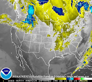
Below is the infrared satellite displaying the system progressing eastward.
As the system treks east, I am expecting it to weaken, as the satellite imagery shows how weak it already is.
So don't be surprised to see some flakes falling; it should make for a nice evening... unless you live up north where the temperature is 0!

Important Notice

It has been decided that, in an effort to place more accuracy in forecasts,
that this blog will now be primarily serving the Midwest US.
However, in the event of a major storm, this blog will be serving the areas needed for discussion.

The Severe Weather Centre will remain directed for the entire US.
The Snow Day Meter will be serving the Midwest, sometimes the Northeast.
The Winter Storm Page may be taken down, but that is still on the table.

Remember to vote on the poll.
It closes in 27 days, and its changes will begin as the votes come in.
It helps me know what you want from us here at The Weather Centre.

Thursday, January 20, 2011

MIDWEST/PLAINS COLD OUTBREAK DISCUSSION

AS AN ARCTIC COLD FRONT MOVES THROUGH THE PLAINS AND MIDWEST TODAY, TEMPERATURES WILL PLUMMET.
WIND CHILLS IN CHICAGO, ILLINOIS ARE EXPECTED TO BE BELOW 0, WITH TEMPERATURES SIMILAR IN NATURE.
GREEN BAY, WISCONSIN WILL HAVE A LOW OF -8 TONIGHT, WITH WIND CHILLS -20 TO -30 BELOW.
MINNEAPOLIS, MINNESOTA WILL RECEIVE TEMPERATURES FROM -15 TO -22.
ALL PEOPLE IN THE MIDWEST AND PLAINS ARE STRONGLY SUGGESTED TO WEAR AS MANY LAYERS AS POSSIBLE.
HATS AND GLOVES ARE ESSENTIAL.
FROSTBITE WILL OCCUR IN 30 MINUTES OR LESS IN THESE CONDITIONS.
THIS ARCTIC OUTBREAK WILL BE ENDING OVER THE NEXT COUPLE DAYS, AS TEMPERATURES BOUNCE BACK UP.