Saturday, August 6, 2011

August 6 Severe Weather Discussion

Discussion... Slight Risk of severe weather over North Plains into the Central Plains, with lesser threat in Ohio Valley into Oklahoma region.
Wind shearing in Slight Risk area will not be impressive, with jet stream putting out 50 kts at max. However, this can be enough for a 'weak' tornado to form, thus the low but still present tornado threat. The main threats will be damaging winds and hail. Before we get into that, look at how the slight risk area is laid out. When you see that type of shape in a slight risk area, that is a good sign that A) A squall line will form, or B) There is a cold front. In this scenario, there is indeed a cold front, and it appears that option B is what we will go with. The SPC mentions 'organized strong storms', which would indicate a squall line, or a cluster of storms out ahead of the cold front. At this time, it looks like the GFS favors a storm cluster in the northern severe risk area, with a squall line forming in southern portions. Sketchy CAPE forecast indicates levels will struggle to reach 2000 j/kg in northern regions, but surpass 3000 j/kg in southern sections. Some shearing in the atmosphere could lead to stronger and more intense storms.

Friday, August 5, 2011

August 5: Flood Warning (Evacuations and Rescues Underway)- Charlotte, NC


THE NATIONAL WEATHER SERVICE IN GREENVILLE-SPARTANBURG HAS ISSUED A

* FLOOD WARNING FOR RAPID RIVER RISES IN...
  CENTRAL MECKLENBURG COUNTY IN THE PIEDMONT OF NORTH CAROLINA...
  SOUTHWESTERN CABARRUS COUNTY IN THE PIEDMONT OF NORTH CAROLINA...

* UNTIL 630 PM EDT

* AT 319 PM EDT...EMERGENCY MANAGEMENT REPORTED FLOODING ACROSS THE
WARNED AREA. OVER 6 INCHES OF RAIN FELL OVER PARTS OF THE WARNED
AREA DURING THE PAST 6 HOURS.

* SOME LOCATIONS THAT WILL EXPERIENCE FLOODING INCLUDE...CENTER CITY
  CHARLOTTE...UNC CHARLOTTE...CHARLOTTE MOTOR SPEEDWAY...EASTLAND
  MALL...HARRISBURG...I-77 AT I-85...MINT HILL...PAW CREEK AND
  SOUTHPARK MALL.

CREEKS SUCH AS STEWART...LITTLE SUGAR...SUGAR...BRIAR...MCMULLEN AND
BACK CREEK ARE ABOVE FLOOD STAGE AND CONTINUE ABOVE FLOOD STAGE FOR
SEVERAL MORE HOURS.

THIS AREAL FLOOD WARNING WILL REPLACE FLASH FLOOD WARNINGS 18 AND 19.

PRECAUTIONARY/PREPAREDNESS ACTIONS...

EXCESSIVE RUNOFF FROM HEAVY RAINFALL WILL CAUSE FLOODING OF SMALL
CREEKS AND STREAMS...HIGHWAYS AND UNDERPASSES. ADDITIONALLY...
COUNTRY ROADS AND FARMLANDS ALONG THE BANKS OF CREEKS...STREAMS AND
OTHER LOW LYING AREAS ARE SUBJECT TO FLOODING.

August 5 Severe Weather Discussion

Discussion... Slight risk of severe weather from North Dakota into West South Dakota, back through NE Wyoming and East Montana. Slight risk also exists in North Mississippi. Elevated threat of wind will exist in the North Dakota region, with a damaging wind event expected.
As of 1:00 PM/ 18Z... 12Z GFS model indicating a hole of no instability existing in North Mississippi, also where a very strong cap over the atmosphere will exist, preventing storms from developing. While a watch is possible for that area, I anticipate that, in the event some storms develop, they will have only some downdraft (thunderstorm cooled winds) instability to work with. 12Z GFS does indicate some potentially strong storms are to break that cap and introduce some severe weather into the area. There is potential for heavy rain, with precipitable water (PWAT) values exceeding 2.5 inches. This means that if all the air in the atmosphere were condensed, there would be 2.5 inches of water in that column of space.
For the Dakotas, instability will remain not too impressive, with readings coming out at 1000-1750 j/kg. However SE North Dakota is expected to break the 2000 j/kg mark for instability, and that could be the strong point of the storms tonight. PWAT values will exceed 1 inch, and could flirt with 1.5 inches in some areas. SFC (Surface) winds will be converging along a front, so there is tornado potential to the north and south of the front.

Notice

Due to the fact the remnants of Emily have a 60% chance of regeneration, we will put the TS Emily page back up just in case.

2011-2012 Winter Forecast: La Nina Watch Issued by CPC

From the CPC


EL NIÑO/SOUTHERN OSCILLATION (ENSO)
DIAGNOSTIC DISCUSSION
issued by
CLIMATE PREDICTION CENTER/NCEP
4 August 2011
 
ENSO Alert System Status: La Niña Watch


Synopsis: ENSO-neutral is expected to continue into the Northern Hemisphere fall 2011, with ENSO-neutral or La Niña equally likely thereafter.
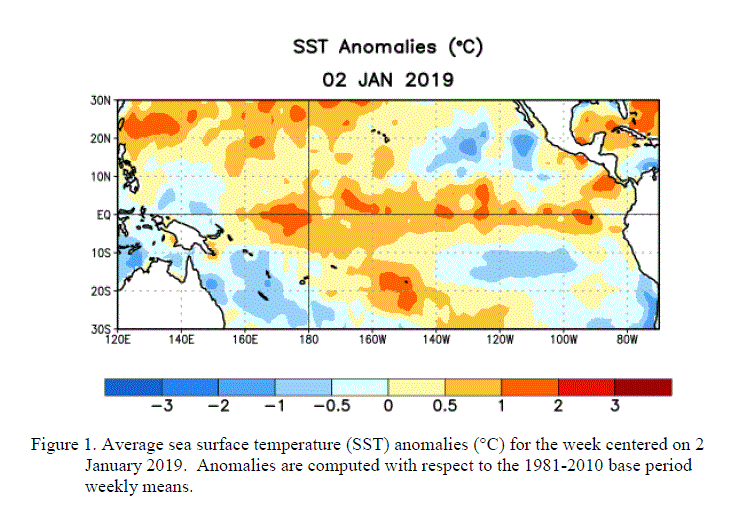
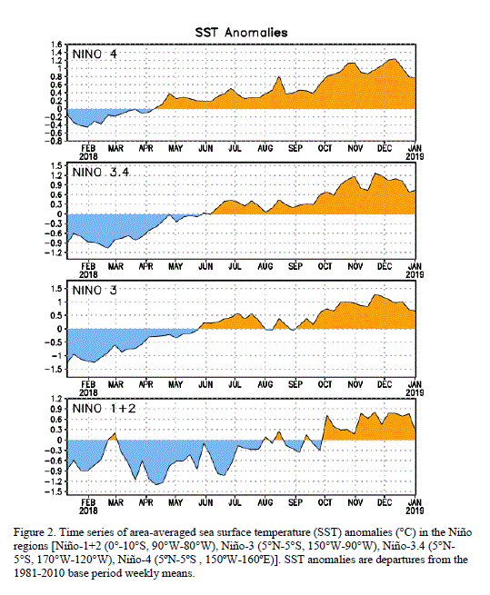
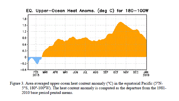
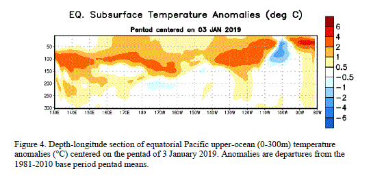
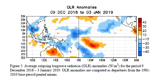
During July 2011, ENSO-neutral was reflected in the overall pattern of small sea surface temperature (SST) anomalies across the equatorial Pacific Ocean (Fig. 1). All of the latest weekly Niño index values were generally near average (Fig. 2), ranging from –0.2oC (Niño-3.4) to 0.5oC (Niño-1+2). However, the subsurface oceanic heat content anomaly (average temperature anomalies in the upper 300m of the ocean, Fig. 3) continued to weaken and is currently near zero, which reflects the strengthening of the below-average temperatures at depth in the east-central Pacific Ocean (Fig. 4). The atmospheric circulation anomalies were more variable during the past month, but the monthly means still reflect aspects of La Niña. For example, convection continued to be enhanced over eastern Indonesia and Papua New Guinea, and generally suppressed over the central equatorial Pacific, mainly south of the equator (Fig. 5). Also, anomalous low-level easterly and upper-level westerly winds persisted over the central tropical Pacific. Thus, while tropical Pacific oceanic anomalies indicate ENSO-neutral, the atmospheric patterns continue to reflect La Niña-like conditions.
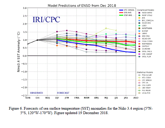
The majority of ENSO models, and all multi-model average forecasts (indicated by thicker lines, Fig. 6), indicate ENSO-neutral will continue into the Northern Hemisphere fall 2011 (three-month average in the Niño-3.4 index between –0.5oC and +0.5oC). Beyond the early fall, the forecasts are less certain with half of the models persisting ENSO-neutral conditions continuously through early 2012. Along with a few other models, the latest runs from the NCEP Climate Forecast System (CFS) models predict La Niña to re-develop during the fall (Fig. 7). This forecast is also supported by the ongoing La Niña-like tropical atmosphere, subsurface temperature trends, and the historical tendency for significant wintertime La Niña episodes to be followed by relatively weaker La Niña episodes the following winter. Therefore, ENSO-neutral is expected to continue into the Northern Hemisphere fall 2011, with ENSO-neutral or La Niña equally likely thereafter.
This discussion is a consolidated effort of the National Oceanic and Atmospheric Administration (NOAA), NOAA's National Weather Service, and their funded institutions. Oceanic and atmospheric conditions are updated weekly on the Climate Prediction Center web site (El Niño/La Niña Current Conditions and Expert Discussions). Forecasts for the evolution of El Niño/La Niña are updated monthly in the Forecast Forum section of CPC's Climate Diagnostics Bulletin. The next ENSO Diagnostics Discussion is scheduled for 8 September 2011. To receive an e-mail notification when the monthly ENSO Diagnostic Discussions are released, please send an e-mail message to: ncep.list.enso-update@noaa.gov.