Saturday, January 14, 2012

Rebuilding Deep Alaskan PV May Return Warmth to East US

Here we have the latest analysis of the Northern Hemisphere at the 400k level to analyze Potential Vorticity (PV). Right now, we can see very little PV values over Alaska (to the up and a bit left of the white circle). This is helping to develop snowy weather over the Eastern United States.
Something we are worried about has, and is still, this PV rebuilding over Alaska. That is looking the case to happen-
This is the 10 day forecast from the ECMWF at the 400k level of potential vorticity. We now see high PV values over Alaska, indicating that the deep low has rebuilt and may lead to warm weather in the East. In case you don't know, higher levels of potential vorticity are associated with stronger low pressure systems.
This rebuilding PV will not help along the snowy weather at all- more of a step backwards, if anything. What is still somewhat reassuring is how we see a jab of low PV values jutting right into the higher PV values, just to the right of the white circle (North Pole). That indicates that a ridge will be in place, helping to keep the stick in the gears, so to say, to keep the polar vortex from completely reforming.
If you have any questions about potential vorticity, because it is a complicated topic, you can ask below and we will try to answer them the best we can, because even I am still learning about it.

February-March Outlook

We are expecting snowstorms to become more prevalent over the Great Lakes and parts of the Midwest as the jet stream begins to dip south from more frequent cold shots, due to the already weak polar vortex. Disregard the Northeast forecast- flip around the ice storm (blue) and snowstorm (red) colors but covering the same areas for the coast in the Northeast. Great Lakes covered in red remain red.

An ice storm risk will still be a worry throughout the Plains and nations midsection, at times reaching into the Great Lakes.

PRELIMINARY PROJECTIONS---
Number of Snowstorms: At least 5
Hardest Hit Region: Great Lakes
Lake Effect Snow Threat: Moderately High

January 15-19 Possible Snow Event (Upper Midwest, Great Lakes Affected)

There is potential for a snowstorm in the Upper Midwest and Great Lakes going into January 15-19 as a low pressure system is forecasted to be right up against the Gary, Indiana area. This is an interesting scenario, and here's why:
NWS Quad Cities Area Forecast Discussion:

.LONG TERM...SUNDAY THROUGH FRIDAY...THE RAIN/SNOW EVENT MONDAY INTO TUESDAY CONTINUES AS THE PRIMARYFORECAST ISSUE WITH ASSESSING SNOW IMPACTS ON TEMPERATURES.
OVERALL...INITIALIZATION AND VERIFICATION GOOD WITH EXISTING SNOWCOVER RESULTING IN COLDER TEMPERATURES AND NW ENERGY SLIDING FURTHERSW THE NEXT 24 HOURS AS OUTLINED IN LAST NIGHT/S DISCUSSION. RUNS
THE PAST 24 HOURS ALL ARE TRENDING FURTHER SOUTH WITH MONDAY SYSTEM
AS WELL WITH INITIALIZATION SUGGESTING THIS TREND MAY CONTINUE FOR AT
LEAST ANOTHER 12 PLUS HOURS.
THE PAST 24 HOURS ALL ARE TRENDING FURTHER SOUTH WITH MONDAY SYSTEMAS WELL WITH INITIALIZATION SUGGESTING THIS TREND MAY CONTINUE FOR ATLEAST ANOTHER 12 PLUS HOURS. IF SO...THIS WOULD LIMIT AMOUNTS WITHBEST FORCING TO OUR SE. VERIFICATION OF LOW LEVEL THERMAL FIELDSSUGGEST HIGHEST WEIGHT TO 80KM NAM-WRF AND HI-RES ECMWF INTO DAY 3AND THEN MORE HI-RES ECMWF DAY 4 ONWARD. THE INCREASING SPEED OFMONDAY SYSTEM SUPPORTS ALSO LOWER AMOUNTS OF PRECIPITATION.


The Quad Cities NWS office is mentioning how the models are moving south with this system, which would indeed bring snow to cities like Chicago that have just been introduced to winter. We have noticed this southward shift in the ensembles as well.
The first image is what the Hydrometeorological Prediction Center, or the HPC is saying right now. The 4 inches part is at max right now, but of course subject to major changes.
Here's what may happen if the models continue shifting south:

Yes, we may see some snow move south as well.
We will continue to closely monitor the ensembles, as it is getting interesting seeing as this event is a mere 3-4 days away.


Friday, January 13, 2012

Major Winter Storm Still On Table as La Nina Weakens

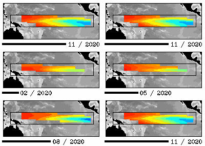
Above is an animation of recent sea surface temperatures (SST) in the ENSO monitoring area. Checking out the animation, we see that the La Nina is losing steam, going along the negative SOI numbers. Negative SOI numbers signify an El Nino.
So why are we still thinking a big snowstorm may happen?

The President's Day Snowstorm of 1979 (President's Day I)
The President's Day Storm of 1979 came during the flip from a La Nina to an El Nino. If that same situation happens with this winter, it is entirely possible that several snowstorm could hit the East US. A flip in the middle of winter is not something that goes by without notice. The entire atmosphere is in a turbulent phase, more than the polar vortex.

In conclusion, while short, we still believe a major snowstorm is possible, depending on, among many other variables, the ENSO conditions. Remember- patience is key; I see the recent Midwest snowstorm to be a very good sign that winter is getting in gear.

Lightning Could Strike Twice for Those Hit by Snowstorm

Those recently affected by the Midwest storm may have to deal with yet another one in less than a weeks time. We are seeing signs that a rain-to-snow event may hit cities like Chicago, IL that recently were hit with up to 8 inches of snow in some localized areas. Here's a map from Accuweather Meteorologist Henry Margusity:
As of now, my confidence in this forecast is pretty medium. The ensembles are in fair agreement over a rain-to-heavy snow scenario for the Lower Great Lakes. The GFS/ECMWF are also in some moderate agreement in placement of the storm.
Something EXTREMELY INTERESTING we found while finishing up gathering snow totals from Chicago was that the Chicago NWS office put out a 'Likely' chance of snow for this system- a rarity considered the horrible model results this year:
We will definitely keep you updated as Old Man Winter wakes up.