Thursday, December 6, 2012

December 9-12 Winter Storm

Models and ensembles remain somewhat unsure on this system, although the modest consensus beginning to form indicates that this winter storm will not be a big event as was earlier anticipated, and snowfall will not be as significant as earlier forecasts had indicated.

The above image shows the GFS model 12z forecast in red, with the NCEP Ensembles in blue superimposed on the image. The GFS model is right in the middle of these ensembles, and they all seem like they know what's going on. However, upon an analysis of other ensembles and model solutions, it becomes clear that the solutions being offered up by different forecasts vary as far as who could get how much precipitation, as well as the billion dollar question: Who will get snow?

The GFS model's snowfall forecast describes a nice storm for Wisconsin and Minnesota. The amounts in Illinois and Iowa were from an earlier system. This snowfall forecast is quite a change from what we had been seeing yesterday, where the models brought big snows to Iowa, Wisconsin and Nebraska. Now, the first and third states look like they're in trouble.

The presence of an east-based negative NAO and a positive PNA trying to sneak in adds to a New England ridge to try and promote a Midwestern storm track for this system. I believe that the GFS has a good handle on the track, but I don't want to trust any precipitation type forecasts until we get this system on US soil, where weather balloon data can greatly help the models in their forecasts.

Andrew

Long Range Lookout: Stormy Pattern Ahead, Cold Lacking


A much stormier pattern looks to be emerging in the next week or two, but persistent cold weather will be lacking.

The above image is today's new 12z ECMWF model forecast at hour 240, or 10 days away. The colors are shown on the legend on the right as 500mb height anomalies. Cooler colors show below normal heights (stormy trend), and warmer colors depict a quieter pattern with above normal heights. Let's dissect the areas of interest I marked off.

1 - Negative PNA

This is usually something that would drive many in the East US up the wall as far as cold and snow potentials being ruined. However, this negative PNA looks like it will come in a more bursting form. What multiple models are showing is that several storms will break off of the original Gulf of Alaska trough and move south, into the West Coast. Typically, they would stick around and hold the negative PNA pattern. However, this regime should incite pieces of energy (strong pieces at that) to move east and actually bring big chances for snow and storms to the central and east US. The question is, where will these storms tend to go?

2 - East Based Negative NAO

We've all heard of the negative North Atlantic Oscillation (NAO) and how it brings cold and snow to the Northeast when it is in this phase. However, exactly where the ridge in Greenland is based is key. The ridge in Greenland is the base of the negative NAO. However, if it is west of Greenland, we call it 'west based'. West Based negative NAO's tend to favor the East Coast for all the cold and snow. If that ridge of high pressure is east of Greenland, we refer to the NAO as 'east based'. In the east-based negative NAO, the Plains and Midwest benefit the most from the storms and cold. If we take a gander at the above ECMWF forecast, it's apparent that we have an east-based (possibly back and forth with west-based) negative NAO. If we then follow up with our negative PNA and its storm train, I would think that the Plains and possibly the Midwest would get in on some stormy action. Precipitation type is a little harder to determine.

3 - Frequent East US Ridging

The reason this isn't a perfect storm with the negative PNA / negative NAO is because of how the negative PNA really works. Due to a depression in heights in the West, physics dictates that we would see an above normal height anomaly (high pressure tendency) to develop in the East. Now, because the storm train that the negative PNA looks to create, these ridges will not be in place for days and days- they should be off and on, depending on when the storms come through. However, this off-and-on solution shows that any snow that sticks in any place will not be welcome to stay for a long period of time.

Looking at the longer range GEFS Control run (a member of the ensembles, but its parameters are unchanged, unlike other ensemble members), we see the negative NAO still struggling to determine whether it's east or west based, and our negative PNA continuing to blast energy into the West.

Something I think should be monitored, however, is the combination of a -PNA, -NAO and -AO. The -AO and -NAO would theoretically open the floodgates for cold, but that negative PNA puts a stop to it reaching the East. That said, I anticipate the cold to stay in Canada and the Northern Plains. The Dakotas, Minnesota, Montana and the like could get in on some of the cold action, but that's about it for the short term.

Despite this GEFS Control forecast, it is essentially one run of the GFS- not worth much on its own. That said, take this forecast for what it's worth. I personally believe the ECMWF has a good forecast going (it has verified well in recent months), and we should see some clarity in the models in coming days.

Andrew

Wednesday, December 5, 2012

Cold January Evolving As Expected

Image from WeatherBell.
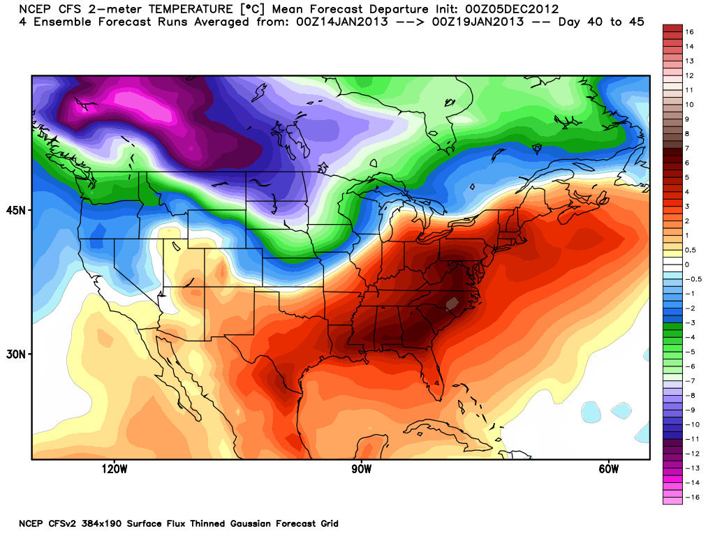
My ideas for a cold January are evolving as expected, with the latest CFS v2 weekly forecasts calling for an outright obliteration of the Arctic floodgates in the 1st to 2nd weeks of January, as pictured above.

Siberia's snowfall, which has a correlation with temperatures in the US during the winter, was below normal in the first half of October. This would call for a warm December and possibly first half of January. As we have already determined, December is lost as for persistent cold and snow. However, as I have been calling for, this winter will be backloaded, with the most cold and snow hitting in January and February.

This CFS v2 weekly forecast for the 3rd week of January shows yet another strong cold outbreak infiltrating the Lower 48 after a brief warm-up. Again, we can see Siberia's October snow cover fitting in here. Siberia did moderate in the middle of October, which would affect January. What I expect based on my findings in Siberia is that cold outbreaks will become stronger in January with each storm that passes through. Periodic warm-ups are inevitable, but cold outbreaks will become more persistent, long-lasting and stronger.

We're still a month away, so this is nowhere near written in stone. However, if Siberia does take hold, cold weather would be expected in the month of January.

Andrew

December 9-12 Potential Major Winter Storm

This is an article concerning the potential for a major winter storm between December 10 and 12. Let's get right into it.

We'll start off with the American GFS model, run by the National Weather Service. This is the 0z model run, meaning it was run at 12z today, or 6:00 AM central time this morning. The GFS model begins its forecast for the storm by having the system moving into southwest Missouri as a weak storm system above the 1000mb mark. Precipitation is widespread north of the blue line, and this blue line is the difference between rain (south of the line) and snow (north of the line). The 12z GFS essentially gives a nice snow event to the states of Kansas and Nebraska at this forecast, which is valid for the afternoon of December 9th. There is also some light precipitation to the north and northeast in response to the advection (movement) of a warm air mass against a colder one.

12 hours later, we are now at the forecast for the early morning hours of December 10th. We see that our system has now moved northeast and has strengthened, with its pressure dropping to 998 millibars, a nice drop from 12 hours ago. Precipitation remains widespread north of the rain/snow line, with Michigan, Iowa, Wisconsin and Illinois getting the brunt of the potential snow. Illinois looks to be in the dicey area as far as precipitation type, as we see the rain/snow line is cutting into te heaviest precipitation to the north of the storm system, meaning possible snow totals could be cut down. I would like to see other models' interpretations of how far the warm air will advect north before I make a decision on if I agree with this forecast.

6 hours later, we arrive in the morning hours of December 10th. It's not the very early morning, just around 6:00 am central time. The system in question has now dropped its minimum central pressure to 994 millibars, indicating a continuation of strengthening within the system. Some backside snow looks to be ongoing in Illinois, Wisconsin and Michigan, with the main event now in southern Canada. A squall line could be forming across the Southeast, based on fairly heavy rain totals in a linear formation. This would not surprise me, as this is a very cold air mass moving south in the wake of this storm system.

This is the Canadian's CMC model forecast, sometimes referred to as the GEM model or the GGEM model. This is hour 114 from last night's 0z (6:00 PM) model run, and the forecast hour puts us in the afternoon of December 9th. The CMC model is forecasting a pretty hefty snow event across much of the Plains, with some of the precipitation associated with this system, and other precipitation associated with another system on the US/Canada border near Minnesota. If this solution were to pan out, several inches of snow could fall in Iowa, Minnesota, Nebraska and Colorado before this system even gets itself out into the Midwest.

We've now moved forward 12 hours, and our disturbance has made its way towards the Midwest. But hang on- is that TWO low pressure systems I'm seeing?? Yes. The CMC model has split our system into two separate systems. This is probably a good time to tell you that the CMC is rarely known as the most reliable model in the weather world, and this solution only enhances such an idea. Anyhow, the CMC model still delivers heavy snow to Iowa, Wisconsin, Minnesota, Nebraska and Kansas, and this solution could bring the first three states several more inches of snow.

This is where the CMC model takes a turn for the weird. The model rejoins the two low pressure systems into one 995 millibar system. As it does this, the CMC model guides the disturbance into Indiana with a very heavy rain mass in tow, possibly an intense squall line. Light snow is now ongoing across Wisconsin, Iowa and Missouri, with heavy rain for all locations south of the blue rain/snow line.

So we've established that the GFS model has a fair idea for its forecast, while the CMC model is doing its own weird thing. Let's keep moving.

Now we move on to the Navy's NOGAPS model. Again, as a forewarning, the NOGAPS model is also known as one of the less reliable models, and tends to print out solutions that sometimes make sense and sometimes leave me scratching my head, saying 'What did I just see?' This is the forecast for the morning of December 9th, meaning that the NOGAPS has this system moving faster than other models. That's something we'll have to watch. Anyhow, the NOGAPS starts out its forecast with a heavy snow event in Colorado, Wyoming, Nebraska, Kansas, Iowa, South Dakota and more. The hardest hit areas would be nearest the storm system (located in western Arkansas). There is a large rain mass extending east of our system, and this could saturate the ground, making it harder for any possible snow to stick in the future.

12 hours later, we see our NOGAPS model taking the system, now with a central pressure of 1010 millibars, in the middle of Indiana. I want to stop and talk about that pressure reading. That is very weak! Much weaker than what other models were showing in above solutions. Already, with the timing issues and now this strength difference, I'm starting to question the NOGAPS model. As for precipitation, heavy snow is still ongoing in Iowa, Minnesota and Wisconsin into Michigan, with lighter snow in Kansas, Nebraska and South Dakota. Heavy rain continues to fall in the Northeast.

Despite the significant timing and strength differences with the NOGAPS and other solutions, the placement of warm air and precipitation does not seem all that far fetched, but I think that it's best to discount the NOGAPS model in the face of these previously-mentioned issues.

It's time to take a look at the ensemble means and not just the models. This is the forecast for 5 days out from last night's 0z model run. The forecast is valid for the evening of December 9th. The GFS Ensembles (commonly called the GEFS) have our system pretty far south on the Indiana/Kentucky border, with some pretty good snow ongoing across the Midwest from Missouri to Wisconsin. Rain continues to fall from Houston to State College according to this average of all the GFS Ensemble members.

Moving forward 12 hours, it becomes apparent that the GFS Ensemble members are becoming more confident with the intensity of precipitation, as we see darker colors appearing in the Ohio Valley and Midwest. If this average of all GFS Ensemble members were to pan out, one would expect a good snow event across the Midwest and Ohio Valley, especially in Indiana and Kentucky into extreme western Tennessee. A potential squall line would be setting up in the Ohio Valley and Southeast, as we have that strong cold air mass crashing into a warmer air mass. The system's central minimum pressure is 1005 millibars, meaning that the GFS Ensemble members are taking this system fairly weakly.

The last forecast image from the GFS Ensemble members shows this system has now moved into the Northeast, now with a deepened central pressure of 1001 millibars, slightly strengthened from our previous image, which was about 12 hours ago. This forecast, now valid on the evening of December 10th, has heavy snow continuing to fall throughout parts of the Northeast, and heavy rain moving towards the East Coast.

So, we have marked out the GFS Ensembles, the GFS model, the NOGAPS model and the CMC model. Of all these solutions, I find the GFS model has a fair idea, although the GFS has been wobbling for a while, and I would like to see a more confident solution.

Either way, we're looking at a possible major snow event for the Midwest, Plains and Michigan. Areas in the Ohio Valley and Northeast would likely not see as much sticking snow, because already-fallen rain has warmed and saturated the ground, significantly melting any snow that tries to stick on the ground.

Andrew

Tuesday, December 4, 2012

Unfavorable Pattern Continues Through December

Preword: Before reading on, please disregard all past calls for a favorable pattern change and good December in recent days. Those prospects are not likely now.

I was one of the first to call for it, and now am one of many beginning to rethink calls for a pattern change. In fact, I'm outright canceling any of my hopes of a more favorable pattern after mid December, and here's why.

This is a short range forecast of the 500mb height anomalies in the atmosphere from the ECMWF Ensemble system. The current pattern has a high pressure system stuck over the Bering Sea into the western Gulf of Alaska. In response to this, we see all the cold and storminess stuck over western and central Canada, with only the Plains benefitting from this. We are also seeing high pressure systems then developing over the East and Central US regions.

That high pressure system over the Bering Sea kind of acts as if you had a piece of string being held up by two vertical structures. This Bering sea ridge of high pressure is one of these 'vertical structures', and the other one is off the Canadian Maritimes. The middle of the 'string' holds the cold and snow, and because those two 'vertical structures' are in place, this 'string' cannot move south and deliver winter-like weather to the States.

Many were calling for a big pattern change around Mid December which would supposedly get us into the real winter pattern we were waiting for and had been denied of last year. Well, here's the new pattern.

This new pattern features some changes. Going back to that string idea, we how have those 'vertical structures' further south, allowing the West US and Rockies to get in on the cold and storminess. This also opens the door for an enhanced storm track over the entire nation. The Bering Sea ridge had prevented such a stormy pattern, and thanks to this new pattern, that problem is gone.

But we have another problem-- the Pacific North American index, or the PNA index.

The PNA's territory is off the West Coast and in the Northeast Pacific. In short, whatever weather happens in the West US, the opposite is observed in the East. So, if we saw a ridge of high pressure in the West, the PNA would be positive and the East would see cool and stormy weather. The negative PNA gives the storms to the West and the warmth to the East.


Multiple forecasts from multiple models and ensemble groups show a definitive negative PNA setting up until at least December 20th. The ECMWF Ensembles show this as well, with the blue areas of below normal pressure sitting over the West US, and suddenly we have a persistent negative PNA. The bottom two images, one being the PNA forecast from the ESRL/PSD and the other forecast from the NCEP. I feel that the NCEP forecast is actually going to turn out good on this one, and the ESRL/PSD may not be the correct forecast this time around.

And just like that, the East gets the short end of the stick, while the West benefits greatly, especially in skiing resorts.

In case anyone's wondering, the North Atlantic Oscillation (NAO) stays neutral-ish around this forecast period, not really benefitting anyone and not trying to demolish the negative PNA.

What this means for the East is that we will still see very unseasonably warm temperatures, off and on. Thanks to the cold and storms now favoring the Rockies, it is probable that these systems will push east and give the rest of the nation a break from warm weather before it gets going again. The polar vortex (a.k.a. the Arctic Oscillation (AO)) looks to be stronger than normal, and you know what that means- enhanced probabilities of warm weather, nationwide.

Andrew