Tuesday, May 28, 2013

Florida Landfall Possible to Open Atlantic Hurricane Season

It looks like the Atlantic Hurricane Season of 2013 is going to get going in the next couple of weeks, as model guidance has begun to push for a tropical cyclone forming in the first week of June, possibly affecting the United States as a result.

We have begun a push into a new weather pattern in the last several days; one that is likely to bring not only additional severe weather events, but additional likelihoods of tropical cyclone formation in the Atlantic. The short range mid-level forecast chart shown above depicts the pattern of West US troughing of low pressure and Northeast US ridging of high pressure that we will be in for at least the next week or two. During this time, it is very possible we will see our first tropical development in the Caribbean basin.

Model guidance has been projecting a weak tropical cyclone to hit Florida in the first week of June, and this guidance has been telling of this projection for multiple days now. The strength of this tropical cyclone has varied in both timeframe and strength, but the general idea of a tropical threat in the first 10 days of June has remained nearly steadfast. Included in this suite of tropical development-allowing model guidance is the European ensemble set and the GFS model, which has been the most prevalent in calling for a tropical cyclone hitting the western Florida coast. The GFS tells of a cyclone that could drop over 2 inches of rain in a 60 hour period over much of Florida. This does not seem like much, but then again you must remember we are a good 10 days out from the first potential shot at this cyclone's formation.

What tells me there is potential for cyclone formation is just how the upcoming weather pattern will match up with the ideal scenario graphic from Penn State University above. In the above graphic, you see high pressure dominating the Atlantic in an action that forces tropical cyclones to move through the Caribbean and Gulf of Mexico basins rather than shoot out to sea. This pattern also enables the chance of a landfalling tropical cyclone to rise significantly. If the projected atmospheric pattern currently in model guidance verifies, we would likely be seeing an eastern Gulf Coast tropical cyclone threat in the first 2 weeks of June.

Andrew

Southern Plains Threatened Again on Wednesday

For at least the third time in at least a week, the Southern Plains will be threatened by an unusually high risk of severe weather. The Storm Prediction Center has issued a Moderate Risk of severe weather in accordance with this heightened risk.

A storm system will begin to reach a negative tilt going into Wednesday, indicating that the highest mid-level vorticity values associated with this storm will be pointed towards the southeast. As a result, the storm system will strengthen and amplify the pattern that this severe weather risk will be in. Strong jet stream divergence to the immediate east of the moderate risk area, as well as a strengthening lower level jet stream will lead to an atmospheric wind field that favors severe weather.

Projected radar reflectivities for Wednesday evening

Projected updraft helicity for Wednesday evening
A special convective WRF model that was run earlier today is indicating that a tornadic environment will share the stage with a damaging wind-style convective cluster. You can see the intense thunderstorm formation over the Plains for Wednesday evening on the top image, and these storms are split into two categories. The first involves the linear thunderstorms spread from central Nebraska down to the border of the Texas and Oklahoma panhandles. The second type of storms is the individual cells in Oklahoma. While one would expect the individual cells to have more potential than the linear system, it looks like the strongest helicity values will be placed inside the linear storm cells.

Regardless of where the highest helicity values end up, anyone inside the moderate risk area should be watchful for the potential of tornadoes, damaging winds and large hail.

Andrew

Monday, May 27, 2013

Tornadoes, Large Hail Possible in Kansas This Memorial Day


There is potential for severe thunderstorms and multiple tornadoes across portions of the Plains on this Memorial Day 2013.

Development of showers and thunderstorms is expected as we move into the evening as a result of low pressure beginning to evacuate the West Coast in favor of the Plains area. The Northern Plains should encounter a slightly less active environment when compared to northern Texas, and this is shown by the Tornado Potential shading being placed more towards the central and southern Plains at this time. I expect storms in the red shading to be strong to severe, although a full-on outbreak is not anticipated at this time. Those in the shaded red region should be alert for strong winds, hail and an isolated tornado.

Convective WRF model projects the development of supercellular storms in central Kansas, and my Tornado Potential region was shifted to account for this prediction. Lower level jet stream is expected to strengthen in speed and size over this region, and at least substantial instability will add to what could be a tornadic equation. I expect any potential tornadoes to affect central and north Kansas into northeast Kansas rather than the whole state.

I used a statewide map to illustrate my primary areas of concern. A north-to-south line from Logan to Coldwater, and northeast-ward line from Bluff City to Mound City will contain the area I believe is at risk for supercell formation. I don't think it's a good idea to project tornado potential, but using the parameters I have at the moment, I have a good idea of where we can expect supercell formation later this evening.

Andrew

Sunday, May 26, 2013

Tropical Discussion - Development, Landfall Possible in Mexico

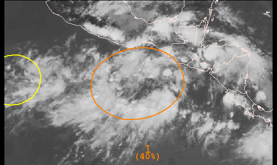
Invest 92 has formed in the East Pacific, and the National Hurricane Center has identified this invest with a 40% chance of tropical cyclone development in the next 48 hours.

Satellite imagery indicates this invest is rather healthy, with multiple areas of enhanced thunderstorms to the south of Mexico. Some of these thunderstorms are even spreading onshore, and this could be a sign of where the invest will eventually end up. For now, no significant circulation is detected by satellite feed, although continued development and dissipation of thunderstorms is clearly shown. If any development is to occur, it would likely start with the southern thunderstorm complex, where storm development is most stable.


Model guidance is showing my main concern with this invest, as current projections have the tropical invest moving almost due northward into Mexico. The consensus is certainly for a landfall into Mexico, although the model spread going towards Mexico is enough so that I am not willing to formally declare a landfall is likely. I do believe, however, that there is a pretty good chance we will see cyclone development and landfall. I say cyclone development because the intensity forecast image below the tracks shows all guidance agreeing in Invest 92 strengthening into a tropical cyclone. A few models even go to bare-bones Category 1 hurricane status, but I believe we will cross that bridge when we get to it.

RISKS
Tropical Cyclone Development: LIKELY
Tropical Storm: LIKELY
Hurricane: POSSIBLE
Major Hurricane: UNLIKELY
Landfall: LIKELY

Andrew

Multi-Day Severe Weather Outbreak Possible

I believe a multi-day severe weather outbreak is possible (if not likely) across the Plains and Midwest over the next 7 days.

The pattern really is primed for such a multi-day event. It begins with an unusually active upper air flow. The image above shows the projected upper air field for five days out. We see an unusually strong Pacific jet screaming into the West Coat above 130 knots at some points. This active Pacific jet will lead to a more active pattern in general for the United States, and will enhance potentials for severe weather.

As the Pacific jet stream amplifies, we will see a more meridional flow set up. If you don't recall, meridional flow is when the jet stream is very wavy and not in a straight line. We are expecting that type of upper air flow in the coming week. As this happens, a general low pressure trend in the West Coast should set up, leading to massive high pressure formation in the Central and East US. This type of synoptic set-up would not be all that different from the pattern that was present for the Moore, OK tornado event. Now, we can't predict if we will see EF-5 tornadoes, because it is practically impossible to predict tornadoes at any given time, unless you're predicting them as they happen.

For this particular multi-day event this week (the days themselves remain uncertain), multiple low pressure systems will be making their way onshore from the active Pacific storm train. A major difference we expect to see between the Oklahoma tornadoes and this upcoming week's potential is that the storms should be further north. I anticipate the Central and Northern Plains to get in on the action more-so than the Southern Plains.

One thing that is very concerning is what the CIPS analog system is putting out. This map combines storm reports from 15 of the best analog dates (dates that have similar atmospheric features as a forecast period (in this case, 5 days away)) into one image. Looking at this image, it is apparent that this potential outbreak would most likely affect states from Minnesota into Oklahoma, but with eastern Nebraska into western Iowa and western Missouri into much of Kansas receiving the highest threat. Note that many of the tornado reports you see in red on the image above included F5 and F4 tornadoes, as this post from AmericanWx shows.

I don't really want to make a map for this week's potential, because I find it to be entering this post with a little too much uncertainty. However,

Andrew