This brief outlook for the winter will be extracted from global sea surface temperatures.
1) La Nina
As has been expected for a while, a La Nina has now emerged. In the image above, we see a stripe of below-normal sea surface temperature (SST) anomalies from the coast of Ecuador to the 180-degree longitude line. The deepest negative anomalies appear to be centered near the 120-degree west line of longitude, also known as the eastern part of the Nino 3.4 region, and extending a bit west into the center of the Nino 3.4 region. As such, this looks to be a 'textbook' La Nina, though then again rarely is anything in meteorology "textbook".
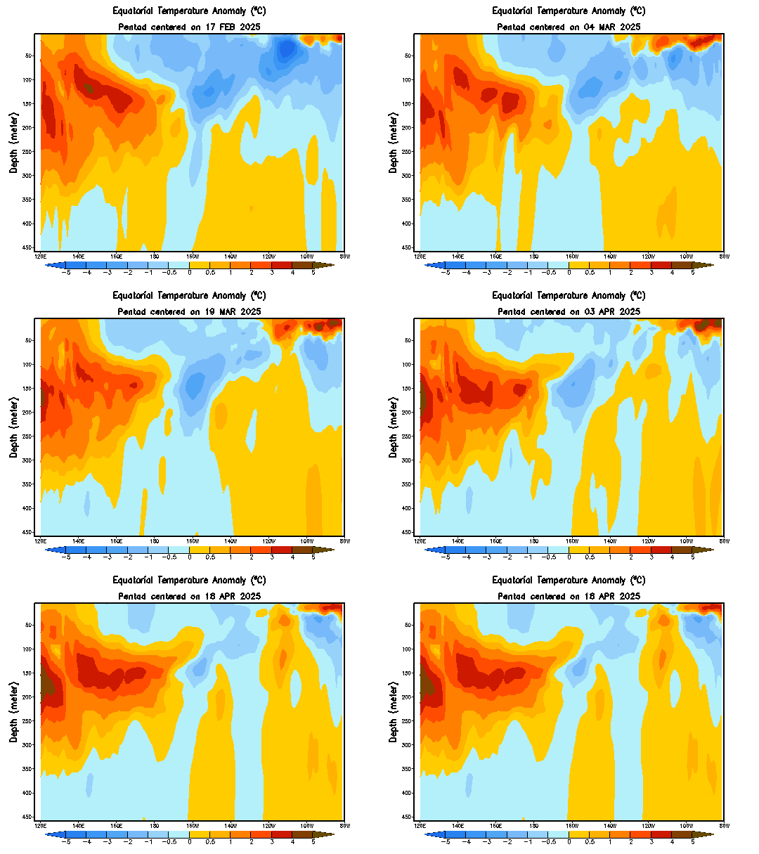
If we look at a cross-section of temperature anomalies along the Equator down to 450 meters below the surface, we see how this pool of below-normal waters has slowly but surely drifted up to the surface from ~150 meters under the surface. After struggling to do so in October, the cold pool has solidified itself on the surface, as we already saw in the top image.
I show this animation to provide evidence that this La Nina looks to be a formidable one, in the sense that it has a reservoir of below-normal temperature waters to continue gradually propagating to the surface. Previous La Nina and El Nino events have been foiled by the lack of a sturdy foundation like this, while others have been eroded away by a body of opposing-temperature waters out to the west, like is seen currently from the surface to 200 meters below. It remains to be seen if this body of colder waters will follow in those footsteps and be eroded over time, but for now it looks rather well-positioned to stick around into the spring.
Effects
The above two images show the typical effects seen from a La Nina in precipitation, on top, and temperature, on bottom. In a La Nina regime, above-normal precipitation is generally seen in the Pacific Northwest, with drier than normal weather observed from southern California through the southern Plains, Gulf Coast and up into the Mid-Atlantic. Some dry signals of a lighter magnitude are also evident in the Midwest, but these are opposed by a swath of wetter than normal conditions generally seen in La Nina years, in the Ohio Valley.
In terms of temperature, cooler than normal conditions are typically observed from the Pacific Northwest through the Upper Midwest, just barely through Maine to the Atlantic coast. Warmer than normal conditions typically dominate the Southern U.S., most strongly in the Southeast U.S. and Texas and Louisiana.
But how do these effects come to pass?
In past La Nina winters, the mid-level flow has shaped up with a strong negative anomaly in western Canada, in what appears to be a core of cold and snowy weather. This is opposed by a strong ridge of high pressure, centered south of the Aleutian Islands but slanted so that it stretches from extreme northeast Russia to the waters just offshore of Baja California.
It is this ridge that shapes the temperature and precipitation anomalies. The Pacific jet stream rides the line between these two extremes, generally pushing southward from Alaska or the Gulf of Alaska, typically then beginning a northward turn when it hits central California. Note the slight positive anomaly in the above image along the Gulf Coast. This is a signal (albeit a very weak one) of the infamous Southeast Ridge that can emerge in La Nina years.
The Southeast Ridge is what I like to call the ridge of high pressure that will typically form over the Southeast in La Nina winters, leading to that maxima of warmer than normal temperatures in that region, but also pushing the jet stream north slightly as that ridge forms to divert the storm track through the Ohio Valley, leading to - you guessed it - the swath of above-normal precipitation usually seen in the Ohio Valley in La Nina winters.
Prediction: La Nina continues through winter and into the spring of 2018.
2) Bering Sea / North Pacific
Another point of interest on that sea surface temperature anomaly at the top of this publication is the patch of above-normal SSTs south of the Gulf of Alaska, in the northeast Pacific. Note how we see that swath of warmer waters seemingly corralled by average or slightly below-average water temperatures that appear to be hugging the Pacific Northwest/Alaska coast. If you think this looks like the negative phase of the Pacific Decadal Oscillation (PDO), you'd be right.
As the above image shows, the negative phase of the PDO is identified primarily by a body of warmer than normal waters south of the Gulf of Alaska, surrounded by colder than normal waters along the coast of North America.
How does this tie in to the La Nina? I'm glad you asked!
As the above image shows, the warm phase of the PDO is generally associated with the El Nino phenomenon, as observed by the warmer colors along the Equator. Similarly, in a negative PDO, La Nina tends to dominate, with the composite image above showing cooler colors (and hence cooler water temperatures) along the Equatorial Pacific. As the sea surface temperatures suggest, we have seen the PDO as negative since July of this year.
Effects
Since the negative phase of the PDO is generally seen with La Nina conditions in the Equatorial Pacific, you might expect the effects of a negative PDO to be similar to that of a La Nina. And you'd be right! As the above image shows, the negative phase of the PDO is shown to generally produce wetter than normal conditions in the Pacific Northwest, drier than normal conditions in the South and Southeast, and wetter than normal conditions in the Ohio Valley. This is remarkably similar to precipitation effects observed in a La Nina, and as such, the forecast adjusts to make this winter look more like a "textbook" La Nina winter.
Prediction: the negative PDO regime stays in place through the winter, though the lack of strong negative SST anomalies along the North American coast makes me wonder if this regime will stay in place through the spring of 2018.
3) Warmth by Nova Scotia
So we should just stop here and say this winter will look more or less like a 'typical' La Nina winter, we should just stop the article here, right? Not so fast. There's something else that's catching my eye.
There's a swath of much warmer than normal SST anomalies centered just south of Nova Scotia, and this has the potential to become an issue for those in the East hoping for a cooler than normal winter.
In general, SST anomalies can be strong predictors of the presence of ridges or troughs over the longer-term. For instance, warmer than normal waters will tend to promote ridging in the longer-term, while cooler than normal waters will encourage troughing in the longer-term. Consequentially, I'm seeing the possibility for ridging becoming a rather common feature along the East Coast into eastern Canada, due to that swath of warmer than normal waters near Nova Scotia.
It's also entirely possible this actually promotes colder weather for the East, by encouraging ridging that then pushes north into Greenland to promote the negative phase of the North Atlantic Oscillation (NAO). However, the negative NAO is typically encouraged by warmer than normal waters *around* Greenland, not well to the south and west, like by Nova Scotia. Time will tell, of course, but I find this factor to be more likely to encourage a warmer winter for the East than a colder winter.
Prediction: Ridging becomes more prevalent than stormier weather in the Canadian Maritimes, potentially working in tandem with the La Nina / negative PDO-induced Southeast Ridge to push the jet stream and primary storm track a little further north and west, affecting both the Ohio Valley and the Midwest.
4) Warm Waters in the Bering Sea
One final sea surface temperature-related factor to discuss is the body of warmer than normal waters present in the Bering Sea southward into the north-central Pacific.
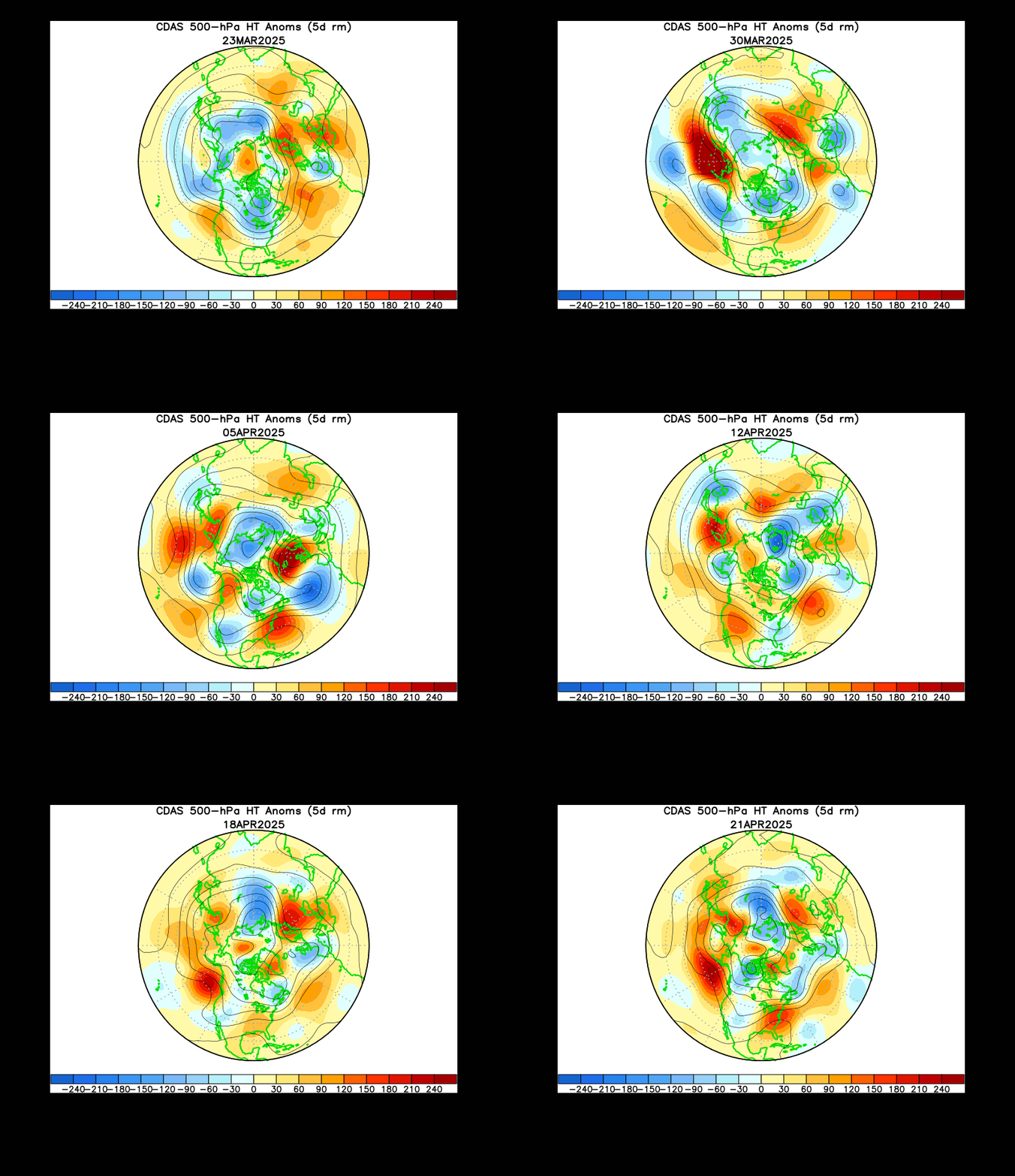
As we discussed previously, SST anomalies can promote longer-term ridging or troughing patterns. This still applies here in the Pacific, and may also complicate the forecast further. The presence of warmer than normal waters in the north-central Pacific and Bering Sea could promote a strong ridge, perhaps evolving into a blocking pattern, which would then trigger a trough forming in the Gulf of Alaska down along the West Coast, similar to the pattern we are in as I type this:
Over the last month or so, we've seen a persistent blocking ridge in the north-central Pacific into the Bering Sea. However, the troughing downstream of this ridge has been variable, moving from the West Coast from 11/3-11/7 to the waters just south of the Gulf of Alaska from 11/18-11/22. The former period saw stormier weather in the West, while the latter period saw a ridge form.
This goes to show how, even though the ridge remained relatively constant in the Bering Sea region, the effects downstream are not as certain. This will add some more uncertainty to the forecast for the coming winter, should these warmer than normal waters remain in the north-central Pacific and Bering Sea.
Prediction: A ridge present in the Bering Sea would introduce uncertainty to the winter forecast, and likely result in stormier weather along the West U.S., which in turn would most likely result in a warmer forecast for the U.S. as a whole.
To Summarize:
- Currently expecting a cooler than normal winter for the far northern Plains and Upper Midwest into New England as a result of the negative PDO and La Nina.
- Wetter than normal conditions likely for the Ohio Valley and eastern Midwest, with drier than normal conditions expected to prevail in the Southeast, Gulf Coast and Deep South.
- The La Nina & negative PDO combination should dictate the broader weather pattern through the winter, with warmer waters in the Bering Sea encouraging meridional flow in the Pacific, and likely an active Pacific jet.
Andrew
 |
| ESRL |
As has been expected for a while, a La Nina has now emerged. In the image above, we see a stripe of below-normal sea surface temperature (SST) anomalies from the coast of Ecuador to the 180-degree longitude line. The deepest negative anomalies appear to be centered near the 120-degree west line of longitude, also known as the eastern part of the Nino 3.4 region, and extending a bit west into the center of the Nino 3.4 region. As such, this looks to be a 'textbook' La Nina, though then again rarely is anything in meteorology "textbook".
 |
| CPC |
I show this animation to provide evidence that this La Nina looks to be a formidable one, in the sense that it has a reservoir of below-normal temperature waters to continue gradually propagating to the surface. Previous La Nina and El Nino events have been foiled by the lack of a sturdy foundation like this, while others have been eroded away by a body of opposing-temperature waters out to the west, like is seen currently from the surface to 200 meters below. It remains to be seen if this body of colder waters will follow in those footsteps and be eroded over time, but for now it looks rather well-positioned to stick around into the spring.
Effects
 |
| ESRL Typical precipitation anomalies in a La Nina |
 |
| ESRL Typical temperature anomalies in a La Nina |
In terms of temperature, cooler than normal conditions are typically observed from the Pacific Northwest through the Upper Midwest, just barely through Maine to the Atlantic coast. Warmer than normal conditions typically dominate the Southern U.S., most strongly in the Southeast U.S. and Texas and Louisiana.
But how do these effects come to pass?
 |
| ESRL Typical 500mb geopotential height anomalies in a La Nina |
It is this ridge that shapes the temperature and precipitation anomalies. The Pacific jet stream rides the line between these two extremes, generally pushing southward from Alaska or the Gulf of Alaska, typically then beginning a northward turn when it hits central California. Note the slight positive anomaly in the above image along the Gulf Coast. This is a signal (albeit a very weak one) of the infamous Southeast Ridge that can emerge in La Nina years.
The Southeast Ridge is what I like to call the ridge of high pressure that will typically form over the Southeast in La Nina winters, leading to that maxima of warmer than normal temperatures in that region, but also pushing the jet stream north slightly as that ridge forms to divert the storm track through the Ohio Valley, leading to - you guessed it - the swath of above-normal precipitation usually seen in the Ohio Valley in La Nina winters.
Prediction: La Nina continues through winter and into the spring of 2018.
2) Bering Sea / North Pacific
Another point of interest on that sea surface temperature anomaly at the top of this publication is the patch of above-normal SSTs south of the Gulf of Alaska, in the northeast Pacific. Note how we see that swath of warmer waters seemingly corralled by average or slightly below-average water temperatures that appear to be hugging the Pacific Northwest/Alaska coast. If you think this looks like the negative phase of the Pacific Decadal Oscillation (PDO), you'd be right.
 |
| NCSU Typical sea surface temperature anomalies in a negative PDO |
How does this tie in to the La Nina? I'm glad you asked!
 |
| University of Washington Broader view of SST anomalies in the warm phase (positive) and cold phase (negative) PDO |
 |
| NCEI Graph showing recent values of the PDO |
 |
| http://la.climatologie.free.fr/enso/enso-pdo3-english.htm#pdo |
Prediction: the negative PDO regime stays in place through the winter, though the lack of strong negative SST anomalies along the North American coast makes me wonder if this regime will stay in place through the spring of 2018.
3) Warmth by Nova Scotia
So we should just stop here and say this winter will look more or less like a 'typical' La Nina winter, we should just stop the article here, right? Not so fast. There's something else that's catching my eye.
 |
| NHC Weekly SST Anomalies, valid 11/18/17 |
In general, SST anomalies can be strong predictors of the presence of ridges or troughs over the longer-term. For instance, warmer than normal waters will tend to promote ridging in the longer-term, while cooler than normal waters will encourage troughing in the longer-term. Consequentially, I'm seeing the possibility for ridging becoming a rather common feature along the East Coast into eastern Canada, due to that swath of warmer than normal waters near Nova Scotia.
It's also entirely possible this actually promotes colder weather for the East, by encouraging ridging that then pushes north into Greenland to promote the negative phase of the North Atlantic Oscillation (NAO). However, the negative NAO is typically encouraged by warmer than normal waters *around* Greenland, not well to the south and west, like by Nova Scotia. Time will tell, of course, but I find this factor to be more likely to encourage a warmer winter for the East than a colder winter.
Prediction: Ridging becomes more prevalent than stormier weather in the Canadian Maritimes, potentially working in tandem with the La Nina / negative PDO-induced Southeast Ridge to push the jet stream and primary storm track a little further north and west, affecting both the Ohio Valley and the Midwest.
4) Warm Waters in the Bering Sea
One final sea surface temperature-related factor to discuss is the body of warmer than normal waters present in the Bering Sea southward into the north-central Pacific.
As we discussed previously, SST anomalies can promote longer-term ridging or troughing patterns. This still applies here in the Pacific, and may also complicate the forecast further. The presence of warmer than normal waters in the north-central Pacific and Bering Sea could promote a strong ridge, perhaps evolving into a blocking pattern, which would then trigger a trough forming in the Gulf of Alaska down along the West Coast, similar to the pattern we are in as I type this:
 |
| CPC Analysis of 500-millibar geopotential height anomalies in five-day tranches over the last month |
This goes to show how, even though the ridge remained relatively constant in the Bering Sea region, the effects downstream are not as certain. This will add some more uncertainty to the forecast for the coming winter, should these warmer than normal waters remain in the north-central Pacific and Bering Sea.
Prediction: A ridge present in the Bering Sea would introduce uncertainty to the winter forecast, and likely result in stormier weather along the West U.S., which in turn would most likely result in a warmer forecast for the U.S. as a whole.
To Summarize:
- Currently expecting a cooler than normal winter for the far northern Plains and Upper Midwest into New England as a result of the negative PDO and La Nina.
- Wetter than normal conditions likely for the Ohio Valley and eastern Midwest, with drier than normal conditions expected to prevail in the Southeast, Gulf Coast and Deep South.
- The La Nina & negative PDO combination should dictate the broader weather pattern through the winter, with warmer waters in the Bering Sea encouraging meridional flow in the Pacific, and likely an active Pacific jet.
 |
| Graphical Forecast |