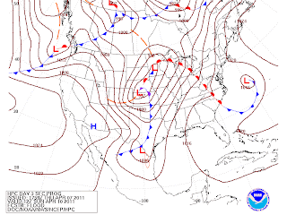
There is a significant severe weather outbreak forecast for the April 8-11 period in the Plains into the Midwest and Southern Great Lakes.
I will not lie to you, I am very concerned about this event. People may lose their lives if they are not careful.
TABLE OF CONTENTS
-The Set-Up
-The Threats
-SPC Images
-Summary
THE SET-UP
Deepening low pressure will eject eastward from the Rocky Mountains. Warm air will be pulled northward in a strong fashion into the Midwest and Great Lakes. A developing cold front will begin to catch up to the low as it ejects from the New Mexico area.
The low pressure will intensify as it enters the Plains area. As he warm front ejects northward into the Upper Midwest, the cold front will be in place to begin the severe storm threat.
Temperatures of 80 degrees will be possible as far north in Chicago. The warm front will be attached to another low located farther north, assuring that the warm front will reach north as it is displayed.
The warm air will be creating a strong cap, letting instability build, potentially to massive limits. Dewpoints will be at extremely high levels, also indicating there will be high values of humidity in the area.
THE THREATS
After analyzing parameters, I have prepared a set of images displaying the maximum threats for the storms.
First, we will start off with the Significant Tornado Parameter (STP) from the 18z NAM.
The NAM shows a significant tornado threat in the Midwest into the Great Lakes. Cities in this threat include Chicago, IL.
The next image will be from the 12z GFS.
The GFS goes more with a squall line and puts more threat in the northern area of the squall line.
These threats alone are very concerning. People should be watching this situation very closely if you are in the orange area or above in any of these images.
SPC IMAGES
The Storm Prediction Center has been outlining this area for a couple days now, obviously indicating a potentially significant severe situation.
The Storm Prediction Center says that the main threats will be damaging winds and tornadoes. Large hail will also be a concern. However, eventually the threat will shift to damaging winds.
SUMMARY
There will be a significant severe weather event in the Plains into the Midwest as seen in the image just above. There will be a threat for tornadoes and damaging winds.
Please stay with us as we monitor this situation.


No comments:
Post a Comment