This is a look at the state of the atmosphere in relation to what effects the mentioned indices may have on the upcoming winter. This is not a forecast, but is more of a general how's-it-going analysis.
Southern Oscillation Index (SOI)
The SOI, in short, can be used as another indicator to what phase the El Nino-Southern Oscillation (ENSO) is in- an El Nino or La Nina. Values above 8 are used to define a La Nina, and values below 8 on the SOI can suggest an El Nino is present.
Currently, the 30 day average for the SOI is at -12, which would indicate El Nino conditions are present. Should the SOI continue to stay below the -8 mark, the likelihood will increase for a full-blown El Nino to be recognized.
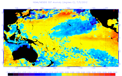
The latest sea surface temperatures across the equatorial Pacific do indicate that an east based El Nino appears to be in progress at this point in time. Temperature anomalies are reaching beyond 1 degree above normal in Nino 1+2, with more moderate anomalies in the Nino 3 and Nino 3.4 regions.
Recent indications are for these warm anomalies to be moving west with time, which could eventually translate into a west-based or (slightly more likely) central based El Nino.
Summary
The atmosphere is primed for an El Nino, and sea surface temperatures are also looking favorable for El Nino conditions.
I was going to post more, but I feel that the rest will be left alone until fall, when the first official winter forecast comes out.
Andrew


No comments:
Post a Comment