Visible Satellite imagery has indicated the dissipation of tropical characteristics of Alberto. As of now, visible imagery is indicating that Alberto is currently a broad area of disorganized showers and thunderstorms. I am seeing no indication of any reformation of Alberto as it moves to the northeast.
Showing posts with label Tropical Storm Alberto (2012). Show all posts
Tuesday, May 22, 2012
Sunday, May 20, 2012
Alberto to Shift Out to Sea in Coming Days
Alberto remains at tropical storm status, however does appear to be fairly weak, with this imagery detecting the strongest part of the storm on the western side, leaving the eastern side fairly exposed to the elements of nature. However, Alberto does look to keep tropical storm strength as it makes a 180 and heads northeast along the East Coast.
These are called dynamic models, which are models that take the information from buoys and surface data near the storm, unlike statistical models, which rely on historical tracks. The dynamic models are projecting a close brush with North Carolina which would likely result in minor beach erosion and weak storm surge from intense waves. After that, the system looks to either go out to sea, or actually pose a threat to New England. That will definitely have to be monitored in coming days.
Andrew
These are called dynamic models, which are models that take the information from buoys and surface data near the storm, unlike statistical models, which rely on historical tracks. The dynamic models are projecting a close brush with North Carolina which would likely result in minor beach erosion and weak storm surge from intense waves. After that, the system looks to either go out to sea, or actually pose a threat to New England. That will definitely have to be monitored in coming days.
Andrew
Saturday, May 19, 2012
Tropical Storm Alberto to Hug East Coast
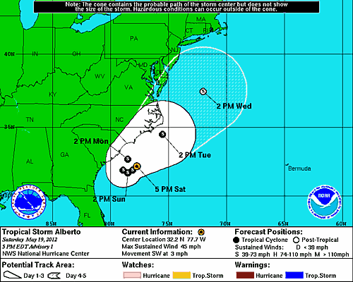
Tropical Storm Alberto is projected to make a u-turn and head northeast along the East Coast, posing threats to both Carolinas over the next few days before heading towards New England. Right now, I would guess, based on historical tracks, that this storm will likely miss the New England area and head towards the far north Atlantic areas. However, the Carolinas remain in the potential target zone and will have to be monitored.
Probabilities for tropical storm winds are mainly the highest out offshore the Carolinas, but the NHC has designated South Carolina with a 30% - 40% chance of tropical storm winds.
Tropical Storm Alberto Forms in Atlantic
Tropical Storm Alberto has formed in the Atlantic at this time. I do not have any graphics right now for the track and intensity, but it is indeed Alberto.
As seen in this satellite image, Alberto does have a strong center and rotating cloud bands, indicating that this system is attempting to acquire tropical characteristics, and it does seem to have achieved that.
More to come.
Risk chart
This is the risk chart concerning Alberto's potential landfall from the Tropical Cyclone Track Probability agency at the Florida State University.As seen in this satellite image, Alberto does have a strong center and rotating cloud bands, indicating that this system is attempting to acquire tropical characteristics, and it does seem to have achieved that.
More to come.
Subscribe to:
Posts (Atom)


