Friday, February 14, 2014

February 15-16 Potential Blizzard

It looks like there is now the potential for a blizzard this Saturday and Sunday.

The GFS model shows extreme wind speeds along the coast of the Northeast as another strong storm system rides up the coast in similar fashion as the storm that just ended for the East Coast. We see 10 meter wind speeds over 44 knots just offshore land, with widespread 25-35 knot wind speed forecasts at the height of this storm.

The GFS model indicates the storm will drop accumulating snow along the coast, as the 984 millibar low comes close to land. Despite the proximity of the low pressure system to the coast, the precipitation here will not be incredibly intense. Accumulation is expected, and the wind will be that of borderline-blizzard conditions, but the accumulation will not be significant.

The real fun begins overnight of Saturday into Sunday, as the GFS projects this storm will rapidly strengthen to drop significant snow accumulation on Maine, and this should continue into the day on Sunday. The system will be moving rather quickly, so while significant amounts are expected, it will not be a prolonged event. This also means good news for those of you who like to watch snow come down at high rates (i.e. 2 inches an hour or higher), as we'll likely see some pretty high snow rates in Maine from this storm.

This 6 hour snowfall forecast shows the intense snowfall overnight Saturday into Sunday, with the GFS depicting amounts as high as 12 to 14 inches of snow falling in that 6 hour period. If you were to average that out, it would be equivalent to 2" of snow falling every hour, but as we all know, snow does not fall in uniform and consistent rates like that. It's more probable that we would see very high snow rates (possibly 4" an hour at best) for a period of time, with lighter rates mixed in (i.e. 1" an hour or lower).

When all is set and done, here is the total snowfall put out by the GFS model. We can see those high amounts in Maine, but also some good totals in coastal portions of Massachusetts and Connecticut. Again, totals aren't looking to be too bad (I'm not so sure we see the GFS' predicted 10" of snow hit those areas in MA/CT), except for in Maine. The wind will certainly make it feel like a big snowstorm for those further south, though.

The NAM model has a different take on this event, bringing heavy snow to only the extreme eastern portion of Massachusetts, with that jackpot in Maine also moved to the east. Considering we saw the snowstorm along the East Coast a few days ago also further east than what model guidance suggested, it's possible we see a solution like this work out.

I'm wrestling with which solution I like better in this case. On one hand, we have the GFS solution, which seems somewhat-reasonable (compared to the NAM) with the slightly-lower inland snow amounts, but on the other hand, the NAM model being to the east may verify, considering the most recent East Coast storm appears to have been further east than modeled. Needless to say, this forecast will see some fine-tuning in the hours ahead.

Andrew

Sudden Stratospheric Warming Commences in Northern Hemisphere

The winter's most sizable sudden stratospheric warming event to date has commenced.

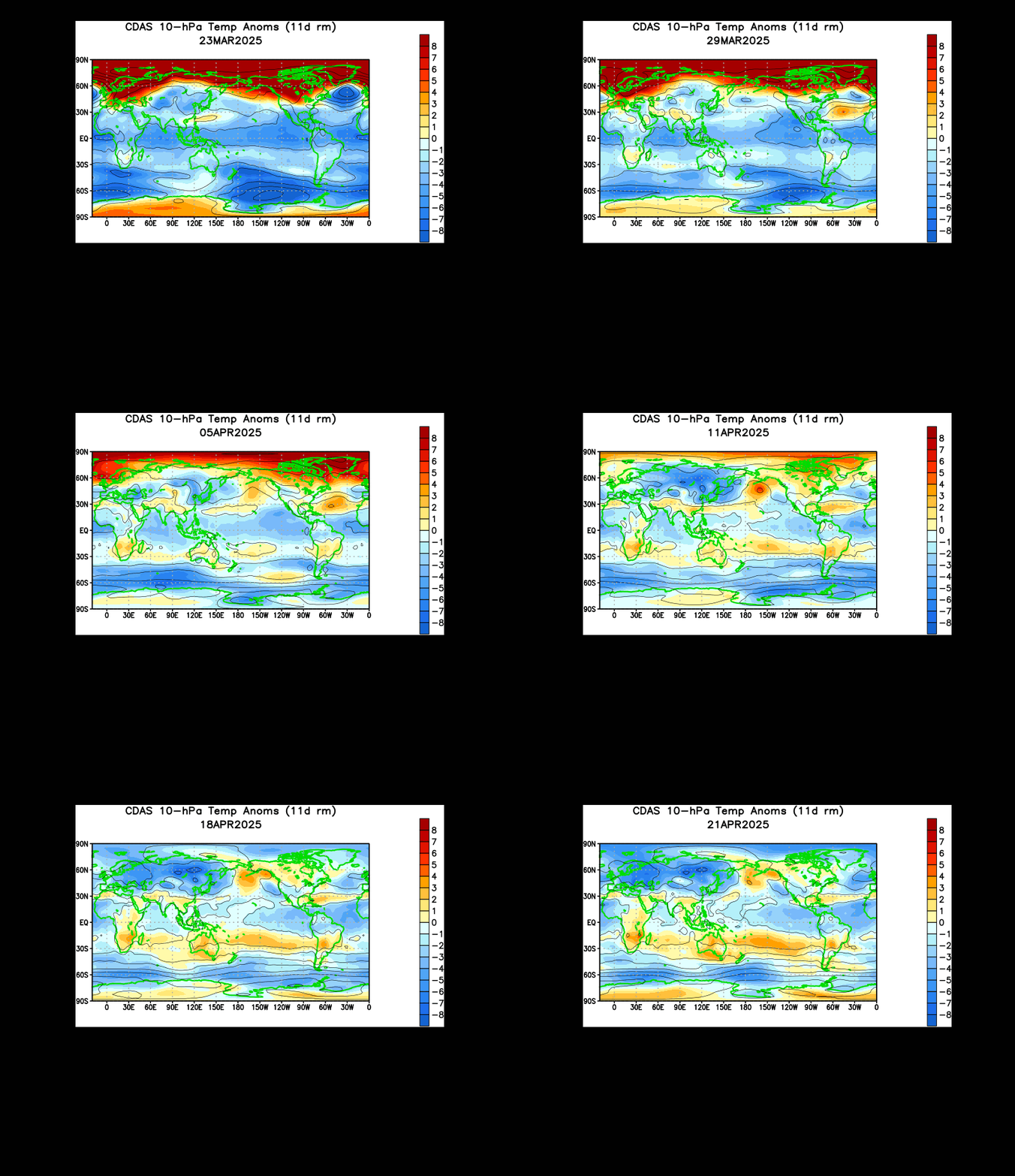
The animation above shows us temperature anomalies in the 10 millibar level of the atmosphere, which is located way up in the upper stratosphere. We see how the stratosphere has been rumbling since mid-January with attempts at a stratospheric warming event, but it is only as of the last few days that the stratosphere saw a massive warming event, titled a sudden stratospheric warming (SSW) event. To see how big this event is, let's head down to the 30 millibar level, located further down in the atmosphere compared to the 10mb level.

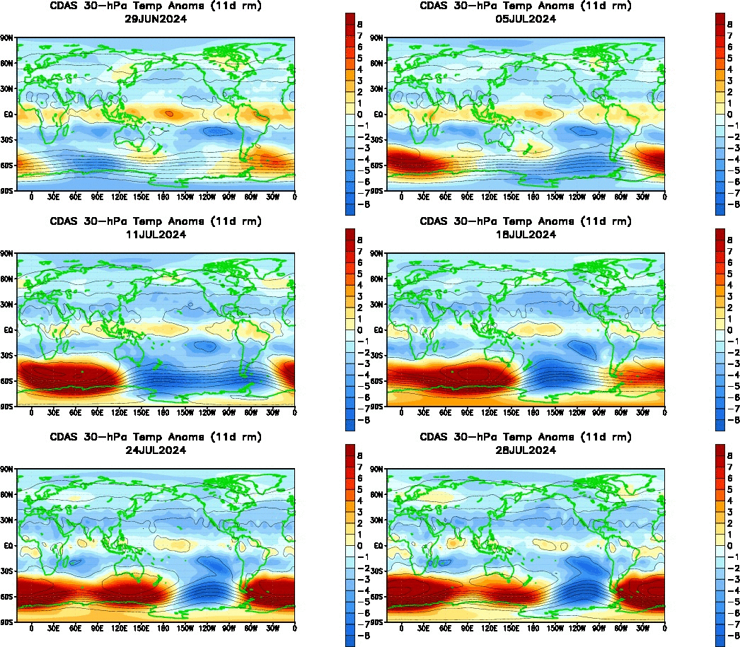
The 30mb temperature anomaly animation above shows how the stratospheric polar vortex has been under attack for a longer period of time compared to the upper stratosphere. We see a large swath of warmth had been developing and manifesting itself in Eurasia in January into February before finally bursting into the upper latitudes. It is now clear that the sudden stratospheric warming event has extended itself into a decent chunk of the stratosphere. Let's check up on the 50 millibar level next.

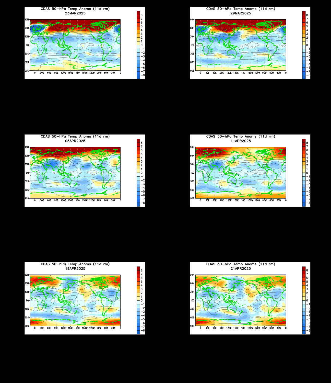
The 50mb level is also seeing significant warming in the upper latitudes, which only confirms the idea that this is indeed a sudden stratospheric warming event, quite possibly the first one we've seen this whole season.

Why is this a big deal? The sudden stratospheric warming phenomenon allows the polar vortex to weaken, and this enhances the possibility of Arctic cold outbreaks not unlike those we saw earlier in January. I'm not saying we will see January 2014-level cold again, the prospects of cold outbreaks rise roughly 2-4 weeks after the sudden stratospheric warming occurs. This would place cold weather prospects in the February 18-March 4th period. It's already looking like we'll see a cold blast to kick off March, and this could be related.

The ECMWF model sees this intrusion on the stratosphere continuing, forecasting continued elevated geopotential-Wave 1 activity at the 10 day forecast period. We see the elevated values maximized around the 3mb to 30mb levels, with lesser influences downwelling as low as the 500mb level. It is likely that this will be the biggest stratospheric intrusion this season, as we are just about to wrap up the meteorological winter season, and the "final warming" (where polar winds reverse to signal the end of the SSW season) isn't too far away.

Andrew

Thursday, February 13, 2014

February 15-16 Potential Coastal Snowstorm

Yet another snow event is possible for the East Coast, with this next threat coming in the February 15-16 period.

WeatherBell
The GFS model indicates we will see another trough develop in the Southeast, with an uncanny resemblance to the storm we are currently fighting through along the East Coast. The GFS sees this storm coming about as a result of the strong-yet-suppressed ridging in the West US, which leads to a west-northwest or northwest flow across the US, a favorable pattern for East US snow events.

The GFS model brings a 984 millibar low pressure system along the waters just off the East Coast, dropping snowfall in the eastern portions of North Carolina, Virginia, Massachusetts, Maine, and all places in between. This snapshot, valid on the evening of February 15, shows the heaviest snow staying offshore, but moderate snow still being able to impact the easternmost parts of the Northeast. As of now, accumulations for regions up to Maine look to be in the 2-5" range.

The storm system really gets going when it approaches Maine, with the MSLP for this storm clocking in at a minimum of 973 millibars. We see 6 hourly snowfall amounts in eastern Maine approaching 12", which would average out to 2 inches per hour for those 6 hours overnight from February 15 to 16. Now, heavy snowfall doesn't fall for 2 inches an hour at that steady rate- my guess is that we would see a period of intense snowfall rates (i.e. 3" an hour not unreasonable) with some lighter snow rates mixed in.

Only a slight shift west or east could flip the forecast- stay tuned for more details about this potential snowstorm.

Andrew

February 22-24 Potential Severe Weather Event

Model guidance is latching on to the idea of a severe weather event in the February 22 to 24 timeframe.

Tropical Tidbits
The GFS model brings unseasonably warm temperatures north on February 22nd, as the graphic above shows. Projected temperatures range mainly in the 60s and 70s, where the warm sector is exerting the most influence. We see the cold front clearly defined, stretching through the Plains and Upper Midwest, with the warm front pulling that warm, moist air far to the north in what would likely be a set-up for the first severe weather event of the season.

Tropical Tidbits
Jet stream analysis from this same GFS model shows the storm system positioned in Wisconsin as a strong 988 millibar low pressure system. We see a jet streak in the 130 knot range positioned to the east of the trough, indicating the storm has become negatively tilted and is expected to continue lifting north and east. These strong jet stream winds, combined with the warm and moist air (containing up to 1.6" of precipitable water across the warm sector), would likely produce a severe weather event. The negative tilt of the trough, shown below, would further enhance severe weather prospects.

Tropical Tidbits
The negative tilt of the trough, shown best when maximum vorticity values are positioned on the eastern side of the trough and contour lines seem to be pressing in a southeast direction, indicates that the storm system has reached maturity, and is therefore more able to produce significant weather. In this particular case, with temperatures only projected to be in the 60s, PWAT values to only be around 1.6", and the jet stream maxing out at 130 knots, I wouldn't be holding my breath for a big severe weather outbreak. However, this solution looks good for at least some severe weather.

Tropical Tidbits
The 700mb winds and vorticity chart for February 12th shows us that lower level winds will be reaching into the 40 knot and 50 knot range, which, while not all that impressive, solidifies my concerns that this may still be a severe weather event, albeit not as intense as a full-out "outbreak".

Because this event is still in the long range, model guidance will inevitably change with this storm system. It is possible we don't even see a severe weather event at all, and it's also possible the severity of this event increases as we get closer to the event. I would bet my money more on the weakening prospects, as the atmosphere still looks a little 'wintry' to me, if you will, and doesn't seem all that conducive for a big severe weather event.

Andrew

Monday, February 10, 2014

February 12-14 Potentially Historic Winter Storm

Things appear to be coming together for a potentially historic winter storm, though model biases mean intense model forecasts are likely overdone.

This image shows the ECMWF model's snowfall forecast for the next 144 hours, and it is not that hard to see the big storm system this model believes will strike a large portion of the Eastern US. We see that the ECMWF model begins by dropping heavy snow in excess of 12" on the areas of northern Georgia and the Carolinas into western Tennessee and Kentucky, before amounts max out near 2 feet in the Virginias. Heavy snow continues into the Northeast, with widespread 12-18" totals across the map for that region.


The ECMWF model has remained consistent on this idea of a major winter storm for the East Coast, including the Southeast. These big amounts are relatively unchanged from previous forecasts, except for the 24" jackpot zone in the Virginias. The environment looks highly favorable for an East Coast storm synoptically, with a west-northwest flow solution prevailing over the contiguous United States. This is shown well by storminess in Alaska leading to strong yet suppressed ridging over the Southwest US. Considering northwest flow scenarios typically can lead to Northeast snow events, it is of little surprise that a strong storm system in the Southeast is able to shift northward and ride the coastline to produce heavy snowfall across the far Eastern US.

The CMC model (Canadian model) above shows heavy snow extending from far northern Georgia to eastern Canada, in a similar fashion as the ECMWF (though not identical). The heaviest snow hits Maine, where amounts flirt with the 16" benchmark, and the remainder of the East Coast stays within the realm of 6-12" or a little higher, as the model shows some higher totals in New Jersey and a few other coastal places.

Surprisingly, the CMC model may have shed its too-snowy bias in this forecast and is actually showing a more reasonable solution compared to the ECMWF. It does look like the crucial point will come when we determine how far south the storm system goes. In the ECMWF's forecast, the storm is a bit to the south of the CMC, hence the heavier snow totals located deeper into Georgia. In future forecasts, I wouldn't be surprised to see totals bumped up a bit along the coast, but other than that, this forecast isn't that far fetched in my eyes.

Lastly, we see the NAM model's snowfall forecast above. The NAM drops heavy snow amounts of over 12" in a large swath of Georgia in what would be a truly paralyzing snowstorm for those who went through the agonizing snow event in Atlanta just a couple of weeks ago. If we look at the NAM forecast further north, we see the heavy amounts extend into the Carolinas, and a strip of 24" to 31" snow amounts in eastern Virginia and the coastal portion of the Mid-Atlantic. The heavy snow then continues into the coastal New England area, but the full storm is not in the NAM model's forecast timeframe yet, so we cannot get total snow amounts in the Northeast yet. Regardless, it's clear that this event would be historic for those down south.

The NAM model is notorious for making forecasts laden with a noticeable too-snowy bias. I expect that this forecast is well within that bias, and it would be wise to cut totals in half or so to be safe until we get closer to the event. Amounts in the Southeast also are unlikely to end up as high as they are shown- I would expect totals maxing out at 6" at this time.

Andrew