The Quasi-Biennial Oscillation (QBO) is an oscillation measured by the direction and intensity of winds in the middle of the stratosphere, usually around the 30 millibar level. When the QBO is in its positive phase, winds are called 'westerly', as they flow from west to east at an anomalously high speed. The positive QBO typically strengthens the polar vortex, thus resulting in a warmer than normal winter for lower latitudes. The negative QBO is when winds at the 30mb level are 'easterly', or going from east to west. Since this is the opposite direction as typical low pressure circulation in the Northern Hemisphere, the polar vortex is weakened, and cold weather tends to permeate the lower latitudes more frequently in the winter.

Sunday, April 26, 2009
East Asia/Typhoon Rule
There is a rule, well explained by Joe Renken, that states a weather phenomenon in East Asia will be reciprocated in the United States 6-10 days later. This means that if there is a storm system in Japan on a certain day, we can expect a storm in the US 6-10 days after that. The same goes for high pressure and warm weather.
Example: A storm system strikes Japan on December 5th.
Result: A storm system can be expected in the United States sometime between December 11-15.
Example: High pressure and warm weather dominate East Asia from March 3rd to 10th.
Result: Warm weather can be expected in the United States sometime between March 9-20.
Lezak Recurring Cycle (LRC)
The Lezak Recurring Cycle, or LRC, is a tool developed by meteorologist Gary Lezak that, in essence, can enable forecasters to predict the overall weather pattern months in advance. The gist of the LRC involves a cycling weather pattern that develops in October and November of each year; no pattern is the same from year to year. Around mid November, the LRC begins to repeat, meaning we start to see a similar weather pattern in mid November that we saw in early October. This means that the cycling pattern has begun, and it will continue to cycle on a regular, unchanging 40-60 day interval for the next ~10 months before it dissipates over the following summer.
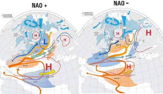
North Atlantic Oscillation (NAO)
The North Atlantic Oscillation (NAO) is an index that can help us calculate the risk of wintry weather impacting the United States. When there is strong high pressure over Greenland, the NAO is said to be negative, and the jet stream buckles south to send cold air into the East US. The jet stream also bends north along the East Coast to help out the prospects for coastal storms. In positive NAO scenarios, strong low pressure dominates Greenland, leading to a mainly west-to-east jet stream, not too wavy, lowering the risk of significant cold or warm weather intrusions.
Example of positive NAO and negative NAO.
Subscribe to:
Posts (Atom)