

Sunday, April 3, 2011
Storms Exploding (April 3)
Links will be posted to warnings.
5:07 pm CDT April 3, 2011 Severe Weather Discussion
Convective Inhibition, which suppresses thunderstorms, appears to be ready to break any moment. Large CAPE values (atmosphere instability) ensure storms that develop will be strong.
A Mesoscale Discussion has been issued on this matter, and The Weather Centre posted it in the post below this discussion.
The main threats will be large hail and damaging winds. However, isolated tornadoes are also possible.
Keep your eye to the sky, these storms will be dangerous.
A Mesoscale Discussion has been issued on this matter, and The Weather Centre posted it in the post below this discussion.
The main threats will be large hail and damaging winds. However, isolated tornadoes are also possible.
Keep your eye to the sky, these storms will be dangerous.
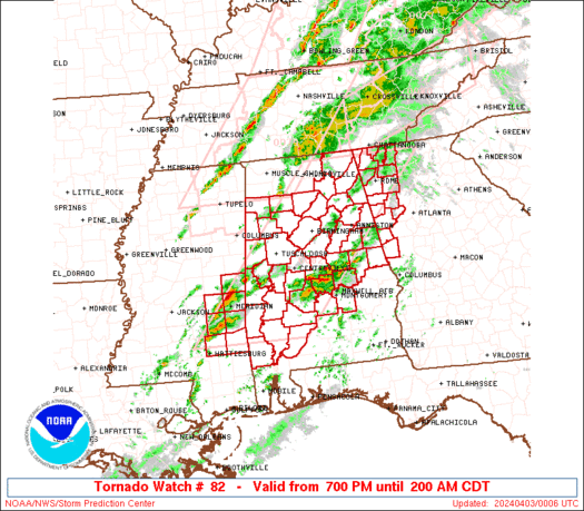
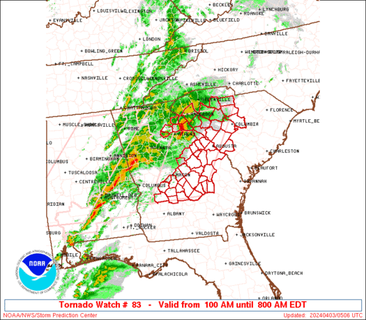
Severe Weather Outbreak is Beginning
The April 3-5 Severe Weather Outbreak has begun with a mesoscale discussion from the Storm Prediction Center. Below is the image.
 Thunderstorm initiation is imminent, meaning storms will begin at any moment. The main threats will be large hail and damaging winds. Isolated tornadoes are also possible.
We will issue updates as they happen.
We will issue updates as they happen.
Notice
I have been issuing many images that may be startling to some people.
In order to clear the air, I want to remind everyone that tornadoes are incredibly difficult, if not impossible, to predict.
An image suggesting tornadoes is simply giving people a heads-up.
I do NOT expect there to be a massive tornado outbreak.
I do NOT expect an F5 tornado to come to.
I DO expect severe storms.
If this was a major event, I would say that.
This will be a minor event.
April 3-5 Severe Weather Outbreak Series: RUC STP (10:02 am CDT, April 3)
The RUC model is being unusually aggressive with the Significant Tornado Parameter for tonight's storms.
Below is an image form 13 hours out, then an image for 17 hours out.

 The RUC is hinting that this may be a tornado outbreak for the north area in this squall line, something the other models have not really picked up on. We will wait and see.
Below is an image form 13 hours out, then an image for 17 hours out.


April 3-5 Severe Weather Outbreak Series: The Write-up (April 3)
Today, severe storms will impact the Plains and Midwest with force, initiating a squall line over the area.
THE SET-UP
A strong cap will develop over the area, suppressing storms. Around 10:30 CDT tonight, that cap is expected to break, and storms will initiate over the area.
Timing is not spot-on, so development could occur between early this afternoon or late this evening.
The cap will hold in warm, moist air, allowing for instability to build up.
Already, at the time of publishing, CAPE values of 3000 were in the Plains, indicative of a very unstable environment.
The squall line expected will form from a cold front, as a warm front drags warm, moist air north and the col front slides east.
THE STORMS
The storms will come from the South and strengthen into an organized squall line. These storms will be capable of producing hail 1-2 inches, heavy rainfall, winds gusting up to 70 mph, and tornadoes.
The tornadoes will be possible early on in the storms.
April 3-5 Severe Weather Outbreak Series: Storm Prediction Center Outlook (April 3)
Overall Risk:
 The Storm Prediction Center upped the risk from Slight to Moderate in Northwest Missouri into East Kansas. The reason for that is not tornadoes, but for a threat of hail. That image will be shown below.
The next image will be the threat for large hail.
 In the above image, we see the region of hail threat that sparked the moderate risk area. With that in mind, it can be expected storms with strong lifting will occur, lifting the raindrops up into the air, high enough to create hail.
The next image will be the tornado outlook.
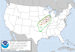 The tornado risk above is aimed more towards North Illinois than anyone else. The Weather Centre indicates this goes along with Significant Tornado Parameters observed today.
Next image will be the threat of damaging winds.
 The Damaging wind threat spans the tornado threat and hail threat, indicating the low level jet stream which will feed the storms will be strong tonight.
In summary, the worst weather is from North Illinois Southwest into Missouri and East Kansas.

The next image will be the threat for large hail.

The next image will be the tornado outlook.

Next image will be the threat of damaging winds.

In summary, the worst weather is from North Illinois Southwest into Missouri and East Kansas.
April 3-5 Severe Weather Outbreak Series: 6z NAM/GFS Significant Tornado Parameters (April 3)
Images first from the NAM, then GFS.
NAM starting at hour 18

 The NAM did push up on this Significant Tornado Parameter overnight, allowing for a hotspot to develop in North Central Illinois. There is where we are likely to see at least some weak tornadoes.
Next, we will feature the GFS, starting at hour 24.
 The GFS definitely puts Northwest Illinois up as a hotspot for tornadoes, and it appears that is where the action will occur.
NAM starting at hour 18


Next, we will feature the GFS, starting at hour 24.

Subscribe to:
Comments (Atom)