Tuesday, February 8, 2011

25,000 views!

Tonight, minutes ago, we reached 25,000 views.

I am humbled to be viewed so much, and hope to provide you with as much valuable information as possible now and in the future.

Thank you.

Snowday likelihood for South US Feb. 8-9

OKLAHOMA:
Feb. 9- VERY LIKELY
Feb. 10- VERY LIKELY
Feb. 11- VERY LIKELY
Week of Feb. 14-18: VERY LIKELY

NEBRASKA:
Until Feb. 18: VERY LIKELY/VERY POSSIBLE

SREF 15z Feb. 8-9 South Storm Snow Images

Images are 12 hour average forecast from SREF members. Based on reputations for the SREF, I am investing confidence in these images.


From the SPC SREF

Feb. 8-9 South Snowstorm Amounts Forecast

This is the first, only, and final SnowCAST of this storm.

South US Snowstorm QPF

Below is the QPF.
For Southern folk that are not as familiar with ratios, the average ratio is around 10:1.
For a first glimpse, Oklahoma would be hit with 7 inches of snow; a truly crippling storm for the South.
However, due to many factors, this may not be possible.
Using the reputed SREF model forecast, the maximum forecast shows Oklahoma receiving well over one foot of snow. The mean amount, which is the amount that would be good to go with, is coming in at possibly over a foot for many areas, mainly in Oklahoma.

OFFICIAL OKLAHOMA FORECAST: 12-24''+ POSSIBLE


Amounts in Snowfall.

Feb. 8-9 Cold Outlook/Concerns

CONCERN
-The LOT office of the NWS is only holding a Wind Chill Advisory until noon on Wednesday. However, coldest temperatures will occur WEDNESDAY NIGHT. That thinking leads the meteorologists at The Weather Centre to believe a wind chill watch or warning may be issued for that area, succeeding that advisory.

NESDIS Piece on 2010-2011 Great Lakes Winter Outlook

"La Nina conditions are now occurring in the Pacific Ocean. Typically, La Nina brings colder temperatures over the Great Lakes and more than normal ice conditions." This is one of the statements in the Great Lakes Seasonal Outlook for Winter 2010-2011. This Dec. 14 photo of the iced Cleveland Harbor West Pierhead Lighthouse on Lake Erie certainly supports the above statement.


However, the Outlook also states that "temperatures were milder than normal over the Great Lakes during the last 4 La Nina (1998-1999, 1999-2000, 2000-2001, and 2007-2008)" and "near normal temperatures are forecast for the month of December." "This season has gotten off to a quick start thanks to cooler than normal air temperatures across the lakes. With the Climate Prediction Center suggesting below normal temperatures likely over the next three months, we may be looking at a more typical La Nina year, with more severe ice conditions than normal," states the National Ice Center's (NIC's) Great Lakes Analyst, Brian Jackson.

Feb. 8 South Winter Storm In-Depth Analysis

Below is the first short range image. We see the storm beginning to strengthen as it enters the South US.
Below is the second short range image for 6 hours or so in the future. The low pressure has strengthened and the storm is providing snow to the South.

Below, another 6 hours forecast, the storm is at its peak for the Southcentral US. The storm is now dropping loads of snow, up to 8 inches, in some places in Oklahoma.


For our final short range image, we see the storm moving away from the Southcentral US, while some areas are still getting hit hard.

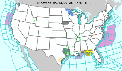


Below is a current watches and warnings associated with the storm. The pink are winter storm warnings. Purple are winter weather advisories, and dark blue are winter storm watches. For more information, go to weather.gov
To see when this storm will strike, see the above short range forecasts.

Wind Chill Advisory over the area

A wind chill advisory has been issued over much of the forecast area and quite a bit of the US.
The light blue is a wind chill advisory. Below are current watches and warnings. For more information, go to weather.gov

Feb. 8 Morning Model Report

In the event that someone needs a model report at any given time, this is where they are available.
REPORT
-----------
ECMWF and UKMET are on the same track, but the ECMWF appears to possibly bring the high pressure from Canada down a bit stronger than the UKMET.
The GEM is definitely more aggressive with the high pressure than the UKMET, possibly more than the ECMWF as well. By hour 144, GEM keeps high pressure in control of US while ECMWF has already torn them out of the forecast by then.
The NOGAPS appears less aggressive than the GEM. NOGAPS does pull out the high pressure areas by hour 144, but also appears to let the US have more potential for low pressure development.
The GFS appears to want to be faster with the high pressure, but sticks with a less aggressive solution of the high pressure as it moves south. By hour 144, the GFS is definitely the model with the most potential for low pressure development, as several low pressures fly freely, backing the high pressures into the West US. However, 12 hours later, those low pressures are eliminated, going along with one model in that situation.

CONCLUSION:
Will keep ECMWF/GFS solution for how strong the high pressure will be, will take ECMWF solution of when it arrives. NOGAPS appears to be a good middle point for when the high pressures dissipate.