Wednesday, November 24, 2010

Weather Explained: Training Storms

This is our second segment of Weather Explained, where we explain unknown weather words and phenomenon.

This segment will focus in on Training Storms.

What is Training?
Training is when precipitation begins to reappear over the same area over and over again.
Radar shows this as a line of showers or storms that seems to keep going and keep reappearing with new showers or storms over the same spot.

Why are training storms such a big deal?
Because training storms are the masters of flooding. Ever had a basement flooded? Maybe your street? Your front yard? Storms that train can do that quicker than any other storm.

Are training storms as dangerous as other storms?
Nope. They're the same storms. Kind of like a cell. It divides and reproduces with the same DNA. That's kinda how training storms function.

Can they be tornadic?
Well, if other storms in the same batch, system or front are, then they could be.

This has been the second Weather Explained session. Join us in a few minutes for MesoCyclones.

Special Weather Advisory (East US)

A Special Weather Advisory is now in effect for the Eastern US, starting with Indiana southward in a straight line.

I am issuing this advisory for a HEAVY RAIN fear.

Over the next 7 days, 2 cold fronts will go through the area. Each will explode in Indiana and race eastward as potential squall lines.

In both cases, these fronts affect the entire East US.

How high is the flood risk?
Well, I would say that everyone in this advisory is under a MODERATE risk due to how the same scenario comes up twice in 7 days.

Rain accumulations may be upwards of an inch, with more than 2 inches if storms begin training
(repeating in the same spot).

A watch may be issued for this area going in to Black Friday if the model stays the same.

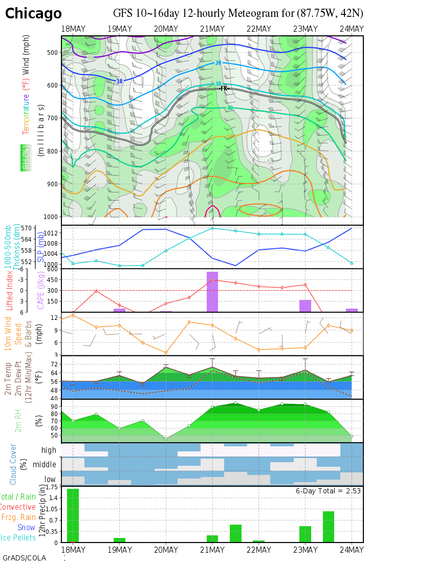
Meteograph 11/24


This is your average-day meteograph.
Let's focus on the lower map. It is a precip map. So, I'm only gonna mention December 4th in to 5th. I predict a possibly significant storm could strike. This is for Chicago.

However, December is still a while away, so we'll have to wait and see.

Snow model runs

The models are spitting out different precip evaluations. But they say that the Lower Great Lakes could see a pinch or two of snow, then snow increases as the front moves off to the East

12/09 Potential Great Lakes Snowstorm Update #1

Well, I ran the GFS and checked out some long-range meteograms (seperate charts).

It has been concluded that the storm system will probably not hit us, rather produce a batch of flurries.

This was expected due to the range of its forecasting.

HOWEVER! A recently updated meteogram indicates that this time period will have a low pressure. Not a low pressure SYSTEM, but a low pressure reading.

This usually indicates some form of weather.

This is the FINAL update for this period unless another event occurs.