Friday, April 26, 2013

2013-2014 Winter Preliminary Model Forecast Overview

This is an overview of what forecast models are currently suggesting may be happening in the time leading into the winter of 2013-2014. This is not my Preliminary Winter Forecast- that comes out in June.

We'll start with the probabilities of different states of the El Nino-Southern Oscillation (ENSO) phenomenon. The red bars on the bar graph suggest the probability of an El Nino, defined by above-normal sea surface temperatures in the eastern Equatorial Pacific. The blue bars represent the potential for a La Nina, which is indicated by below-normal sea surface temperatures in the eastern Equatorial Pacific. As the third name suggests, the green bars predict neutral ENSO conditions, which means there is no presence of above or below normal temperatures in the region. Moving through the year of 2013 to the last set of bars, defined as NDJ 2013 (November-December-January 2013), we see pretty equal chances of each type of ENSO condition, but if you want to be picky we can differentiate between which one is so prevalent. The neutral-ENSO condition has the highest probability (just below 40%), with La Nina in close pursuit (roughly 35%). The chances of an El Nino rise throughout the forecast period, but end up immediately below 30% to round out the predicted El Nino conditions. While the probabilities may seem unusually low right now, you have to remember that we are looking at the end of the forecast period, hence the confidence of the forecast is unusually low. Also of significance is that the winter's ENSO period typically develops during the summer months- this idea is true for nearly every year.

Looking at the OND 2013 (October-November-December 2013) temperature forecast from the long range American CFS V2 model, we see widespread probabilities of below normal temperatures across Canada and creeping into the North Plains and Upper Midwest. We can also see above normal temperatures near Greenland- these warm temperatures could mean high pressure in that region, and this could mean a higher probability of below normal temperatures in the Eastern US. We also see spots of above normal temperatures in the Southern Plains and shying into the Southwest. This may or may not mean a little high pressure tendency in those regions, and this could also try to push below normal temperatures into the East US. Don't get excited yet, however- we're 8 months away from the first month of winter. I can't even describe how low confidence is on this forecast.

As for the precipitation forecast, we see a large swath of above normal precipitation extending from the Midwest and across the Great Lakes. There is an enhanced swath of above normal precipitation probabilities in the Ohio Valley and southern Midwest. This set-up of precipitation is more typical of a La Nina pattern. Below normal precipitation in the Southern Plains adds to my suspicion of that high pressure tendency in the region, and this tendency could extend into the Southwest as the pocket of below normal precipitation in northern California shows. Again, confidence is extremely low.

Andrew

Incredible Closed Low Engulfs US in May

A very unusual weather pattern will be setting up at the start of May, and this unusual weather pattern is one I haven't seen in at least several years.

The image above shows projected vorticity values on May 5th. Vorticity is the spinning of air, and appears in the presence of storm systems. We see high vorticity values centered in the Midwest, curling into a circular formation across the north-central states. This circular motion in the vorticity areas, combined with multiple full-circle contour lines across the Midwest and the general north-central United States region indicates we are dealing with a massive closed low. The closed low is formed when a storm system is cut off from the jet stream and meanders along with little to no influence from the jet stream. Usually, closed lows are relatively small and are more of a nuisance event. This closed low, however, will be of pattern-changing status. This closed low is just like the others, except it will be so large that the weather pattern across North America will be altered as a result.

What can we expect from this event?

The answer is just what you hope it isn't: we are expecting snowfall across portions of the Midwest, Plains and Ohio Valley. At the moment, accumulation appears possible in areas of higher elevation and areas in the western Ohio Valley. The closed low will bring down a massive bubble of cold air from Canada and spread it around the central and east US to provoke multiple chances of (possibly accumulating) snowfall.

Andrew

Upper Stratosphere Becoming Agitated

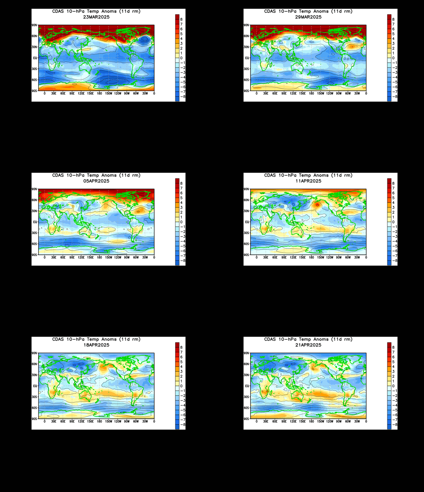
Latest indications from the Climate Prediction Center are that the upper stratosphere is becoming agitated as we enter the heart of spring.

The animation shown above details the last 30 days of temperature anomalies at the 10 millibar level of the world, known as the upper stratosphere. The last month of temperature observations has revealed two bodies of above-normal temperature anomalies. The first body of warmth made an initial push to the Arctic in the Bering Sea, but after the attempt was foiled, the warmth appears to have shifted into Siberia and may be making a second attempt. The second swath of warmth also shifted east from the northern Atlantic into much of Canada. This area of warmth has been more oppressed as far as being able to push north, and it seems to be weakening in the last couple frames of the animation. Nonetheless, the uneasiness in the northern hemisphere tells me that the atmosphere is determined to shift into its summer stages, where bodies of warmth like the ones shown above are not present. Time will tell when this happens, but until it does, I suppose you can't blame the atmosphere for staying in a wintry pattern over the last several weeks.

Andrew

2013 Official Atlantic Hurricane Outlook

Hello everyone, and welcome to The Weather Centre's Official 2013 Atlantic Hurricane Outlook. We begin with my analog package.

We start now with the analog package. I utilized the Pacific-Decadal Oscillation (PDO) and Atlantic Multidecadal Oscillation (AMO) for this outlook's analog years. The PDO involves a positive and negative phase, where each phase depends on the prominent water temperature anomaly in the Northeast Pacific. A glance at the sea surface temperature chart for the northeast Pacific reveals a swath of above normal water temperatures in the offshore regions of the Gulf of Alaska, with below normal temperatures immediately offshore of North America and Alaska. This is the typical signature of the negative PDO. As for the Atlantic Multidecadal Oscillation, we also see a positive and negative phase with this index. The positive AMO signifies warmer than normal water temperatures across the waters off Greenland and in the far north Atlantic Ocean. In the same sense, the negative AMO allows below normal water temperatures to encompass the North Atlantic waters.

After choosing specific years from these two indices, I combined my chosen years and used the ones that had both the PDO and AMO in phases similar to what we are currently anticipating. As a result, I came up with the years 1951, 1952, 1955, 1956, 1999, 2000, 2008, and 2011. All of these years had a clear negative Pacific-Decadal Oscillation and positive Atlantic Multidecadal Oscillation, which is what we are experiencing now and what we should experience moving forward into the spring and summer months.

Let's take a look at an archive of hurricane tracks during the aforementioned years to see if we can see a trend in my analog years that could assist in helping us find a common track for the upcoming season.

1951
In 1951, we saw a storm season that had many storms going out to sea rather than towards the US Mainland. At least 3 of those storms didn't even have a chance of making it to the United States. However, there were a few storms that did have a close brush with the Carolinas, as well as one landfall in Florida. A couple storms did make a threatening track towards the Gulf, but for one reason or another they did not hit the US. One storm (Hurricane Charlie) did hit Mexico, the Yucatan Peninsula, and Jamacia. All in all, the trend for this year was a slight Gulf threat with multiple close calls on the East Coast.

1952
1952 was not unlike 1951 in terms of where tropical systems went. While the Gulf of Mexico was considerably quieter with no systems actually in the heart of the Gulf, there was one landfallig system in the Southeast US, another landfall in Florida, and at least 3 storms that ended up recurving out to sea. The system that struck Florida, which formed on Groundhog Day (yes, in February), was never named. Hurricane Able was the system that hit the Southeast. The trend in this season was a threat to the East Coast and a rather quiet Gulf of Mexico.

1955
1955's Atlantic Hurricane season involved a pretty darn active season in terms of landfalling tropical systems. We saw multiple impacts on the Gulf Coast, especially in Louisiana and Mississippi. We also saw possibly more than 2 separate landfalls on the East Coast, all of which struck the Mid-Atlantic (one also sideswiped the Northeast). Tropical Storm Brenda was one of the systems that hit the Gulf Coast, and it was Hurricane Connie that slammed into the East Coast. Tropical Storm Five followed Brenda into the Gulf, while Hurricane Diane took a hint from Connie and sped towards the East Coast to make landfall. The clear trend here is an active landfalling season in the Gulf and East Coast.

1956
1956 continued the idea of storms running dangerously close to the US Mainland, even making landfall a couple points along the way. We saw a rather unusual season in that the majority of the storms took almost a due-north path out to sea. Usually, storms will form off the coast of Africa and curve west before doing a 180 and going out to sea. In this season, the storms just formed and made their intentions clear as day. Tropical Storm One, the first named system of the season, impacted the Gulf with a landfall. Both Hurricane Anna and Tropical Storm Dora hit Mexico, while Hurricane Flossy did a double-take by hitting the Yucatan Peninsula and the Gulf Coast. An unnamed subtropical cyclone hit Florida and skirted into the Mid-Atlantic. The trend in this season is clear: Tropical cyclone threats were highest in the East Coast and Gulf Coast.

1999
1999 was no different than previous years. We saw multiple tropical cyclones skirt immediately offshore of the Eastern Seaboard, and the Gulf of Mexico came under fire. We saw extreme southern Texas take a landfall from Hurricane Bret, while Florida was surrounded by several near-misses and at least two landfalling systems. It was Hurricane Dennis that took one of the most awkward tracks I have ever seen a tropical cyclone take. It began to curve out to sea after narrowly missing eastern Florida, but suddenly make a hard turn south, then a hard turn west before making landfall in the Mid-Atlantic as a weak tropical cyclone. The trend continues; East Coast and Gulf Coast were threatened in this season.

2000
The year 2000 was a bit different in that the number of threats to the East Coast was reduced. We saw more of a tendency for storms to curve out to sea earlier than storms in, say, 1999. The state of Florida did bear the brunt of at least one landfall (courtesy of Hurricane Gordon), while Alabama and Georgia were affected by a tropical cyclone known as Tropical Storm Helene. A tropical depression also made landfall in the western Gulf Coast, although it is not shown in the map above. The Gulf Coast definitely made headlines as the most affected area this season, with the East Coast in a not-so-close second.

2008
2008 brought an absolutely chaotic Atlantic hurricane season. We saw over half a dozen tropical cyclones hit the Gulf Coast, with one cyclone hitting the East Coast. Tropical Storm Cristobal affected the East Coast, while Hurricane Dolly and Tropical Storm Edouard hit the Gulf Coast. Tropical Storm Fay zig-zagged through Florida, while Hurricane Gustav ravaged the Gulf. Hurricane Hanna hit the Eastern Seaboard, and it was Hurricane Ike that dominated the Texas coast. The trend is probably the clearest we have seen in all of the analog years: The Gulf experienced the largest threat, with the East Coast also getting in the action.

2011
My last analog year, 2011, echoed previous analog years, but also raised the recurring theme of storms curving out to sea. We saw the heavy majority of tropical cyclones curving out to sea in 2011, with little to no damage coming between them. However, there were two Gulf Coast landfalls that were weak, as well as one Mid-Atlantic landfall. The final analog year continued the idea that the US mainland was threatened.

The next piece of evidence I want to show you is a chart of the latest observed sea surface temperature anomalies over the Atlantic Ocean. I outlined three regions of anomalies- an above-normal sea surface temperature (SST) area in and just south of Greenland, a below normal SST area to the east-northeast of the Mid-Atlantic coastline, and a large swath of above normal SST values from the coast of Africa and west into the Caribbean. This type of arrangement of SST anomalies is called an Atlantic Tripole. Years that had an Atlantic Tripole in place had a positive correlation with the monthly hurricane total from June to July and Accumulated Cyclone Energy (ACE) values. This positive correlation means that, since the Atlantic Tripole is in its positive phase right now, we could reasonably expect more tropical cyclones than normal to form this season, and those cyclones could have more energy than normal, which would then raise the ACE index.


I am monitoring the El Nino-Southern Oscillation at this time, and current sea surface temperatures suggest we are wavering between an El Nino and neutral-ENSO conditions. The CFS long range model forecast shown above projects any hint of an El Nino dying off going through the summer months and rest of spring months. A variety of ensemble members from the CFS forecast system average out to produce a neutral-ENSO situation through the hurricane season. The lack of a solid El Nino or La Nina means more weight is placed on smaller-scale factors that we will look at later on in this article.

Based on all the factors listed above, and after observing tropical outlooks from other sources, I have composed a map detailing the areas where I believe a tropical cyclone of any strength (tropical storm or stronger) could strike. Areas outlined in green show the probability of a landfall as 'Low'. This means that climatology and projected atmospheric factors don't especially portray the outlined area as prone to a tropical cyclone landfall. Areas in yellow are denoted as having a 'Moderate' risk of a landfalling cyclone. The 'Moderate' risk means that climatology and multiple atmospheric values tell me the risk of a landfall is above the historical norm, but not by much. Another way to look at it is just over 50-50, favoring a landfall (55-45, if you like). Finally, the red areas depict a 'Fairly High' chance of a landfalling tropical cyclone. I would put 'High', but you can't really put that out unless the outlook is made days before the season starts and your confidence is over 100%. To play it on the safe side, I define the 'Fairly High' category as regions where climatology and multiple atmospheric factors are contributing to what could be the hotbed of activity for tropical cyclone threats to land. It should be noted that this 'Fairly High' region could be extended further west and maybe a tad north if my analysis continues to be favorable for landfalling cyclones. That subject will be addressed further in coming updates as we inch closer to the hurricane season.

Andrew