Wednesday, August 31, 2011

0z Invest 93L Full Ensemble Tracks and Intensity Forecasts in Gulf of Mexico


Video from GOES Satellite of Irene's Path

Here's a cool video from a GOES satellite that watched Irene come onto the East Coast.

Invest 93L's development chances upped to 60% in Gulf of Mexico

The chances of Invest 93L developing into a depression, storm or hurricane in the next 48 hours have increased to 60%, and that number is expected to climb rather quickly at some point soon as upper level winds become more favorable. As soon as that happens, we can expect that we will have 'Lee' on our hands in the Gulf of Mexico. Here's the latest update from the NHC.

We also have some early updates as of 8:00 pm EDT this evening on the invest, and here they are.

Tropical Storm Katia August 31 Evening Update

Hello everyone. You are probably expecting an update of the ECMWF model, but we're going to take a look at surface observations and that kind of stuff. First off we have microwave imagery of Katia
Basically, it shows the coldest cloud tops (most intense convection) in the storm, as well as a generalized view of the center of circulation.
This won't be a long discussion, so here's the ensembles take on Katia.

Gulf of Mexico could be in for Tropical Cyclone 'Lee' by week's end

The Gulf of Mexico could and likely will be in for tropical cyclone Lee. Before we go on, a tropical cyclone is not just a hurricane, but also a tropical storm or tropical depression. The term tropical cyclone is used loosely as such.
This invest will move into the Gulf and then develop into Tropical Storm Lee.
Ensembles are showing Lee has a wide variety of options. The models are not handling this invest well at this time. However, at this time, it is believed that the two main options are south into Mexico, or northeast into Mississippi and Alabama. There is still the other two options on the table, but these are based on consensus and thoughts of other meteorologists.
There is still a lot of time before Lee could develop, and we will keep you informed throughout.
We do not have data yet on the latest 12z ECMWF model or any 12z model for that matter. Next update will be at 330 this afternoon.

National Weather Service to Roll Out New Homepage, Forecast Pages

The National Weather Service will be rolling out a new design on its NWS homepage (See Figure 1) and Local Forecast Pages (See Figure 2). You can click here for the full press release, and click here to publish comments to the NWS about the new design.

Figure 1
Figure 2

August 31: Katia Update: 0z ECMWF comes in north as 4 other models make an East Coast Run

A big development has occurred this morning, folks. After checking the 0z ECMWF, I did an unusual thing and put the ECMWF up against four other models: the GFS, HWRF, GDFL, GEM models. It turns out the ECMWF is the farthest north out of all 5 of the models put together. This is a significant development because it means some models could be calling for an East Coast run.
Here's the multi-model panel 126 hours out- just on the edge of the 5 day forecast.
You can differentiate which models are which by looking at the image headers. You can see maximum wind speed in that same area as well. Here's a piece of information. There are some biases on these models. I only know one or two, and here they are.
-HWRF is stronger than what actually pans out.
Yes, the HWRF is pretty much always stronger in tropical cyclones than what happens, so don't take strength forecasts too seriously. Now compare the 4 panel image to the 0z ECMWF of this morning.
Check out how far north the ECMWF is compared to the other models. This presents a problem to forecasters- which model suite should I choose? There's a majority of somewhat reliable models, up against  a heavy hitter model in the computer model world. Right now, we are not going to choose, but will watch all models carefully over the next couple days.

There is a rumor that Katia's models will have a change coming in the next 2 days as a typhoon will move over Japan.

Tuesday, August 30, 2011

12z ECMWF comes in weaker, out to sea with Katia

Today's 12z ECMWF backtracked on many counts, keeping Katia very small and weak, but strangely curing much farther out to sea much quicker than any run previously.

We are not releasing an official forecast or images for that matter as we are not confident in this ECMWF run or any forecasts at this time.
0z ECMWF trended north this morning, bringing the now tropical Storm Katia out to sea if th ECMWF pans out.

Monday, August 29, 2011

'Katia' could bring East Coast a 919 mb hurricane as per ECMWF

The ECMWF model is projecting a 919 millibar hurricane to aim for the East Coast. In case you don't know how ridiculously strong that is, it is an EXTREMELY big deal. However, remember that ECMWF did not do too well with Irene, so this should not be taken too seriously at this stage.

ECMWF goes west with Invest 92L; East Coast At Risk

Pre-reading notes: ECMWF did well with track of Hurricane Irene but did not do too well with strength in forecasts. We are using ECMWF only because we believe this is the more important model of the GFS/ECMWF comparison. This bulletin is for August 29.

The 12z ECMWF run has fled west with Invest 92L, posing a potentially serious threat to the East Coast yet again. While Hurricane Irene was a minor hurricane (below category 3) at landfall, this system, which would be called Katia, could pose a significant risk to the East Coast (EC) if this verifies.
The time period we are looking at today is the September 6-8 area, when 'Katia' could begin to approach the Florida region. Each image is 24 hours from the previous image.
September 6

So here is 'Katia' on September 6. She is storming NW towards the Florida area. If this were to verify, Katia would likely scrape up the Florida coast and probably come dangerously close to the OBX region again, possibly hitting New England by the time it all ends. However, there remains the potential of Katia going out to sea after the OBX hit instead of New England.
September 7
September 7 features Katia growing massively in size and strengthening as a result. The big question going around is how storms like this manage to sometimes go out to sea. Here's the thing. Another ridge (high pressure) is forecast to develop in the CONUS (continental US) and move eastward. There appears to be a trough of low pressure moving eastward. Depending on how strong or weak it is will determine the ultimate track. If the trough is stronger, the storm will go out to sea (OTS). If it is weaker, as the ECMWF has picked up on here, the storm will have a shot at an East Coast landfall. If you don't understand all of that, focus in on the italicized part.
September 8
At this point, Katia is a monster. She has grown exponentially and strengthened a deal more in a one day period. The ECMWF continues bringing up the storm NW towards the East Coast.

You might be asking 'Okay, so when does the decision making come on whether this trough will make the storm go out to sea or towards the US?' That is an excellent question. Comparing other models against the ECMWF, it looks like we cannot answer that right now, but it would come beyond 5 days from now, so a lot of model watching is to be done.

Projected Forecast Path for Invest 92L (Tropical Depression 12)


Sunday, August 28, 2011

ECMWF considerably north with Invest 92L

This is a special update for Invest 92L.
The ECMWF, proven to be more accurate than the GFS, has taken a dramatic turn north with Invest 92L, sending it out to sea instead of potentially impacting the East Coast. But first, let's take a look at the invest itself.
Invest 92 is quite a vigorous tropical wave that has barely moved offshore of Africa. Already it has a 70 percent chance of becoming a tropical system. Right now, it is moving westward. It does appear that the ECMWF may have initiated a bit north of where the system is now. While that may not seem like a huge deal, in the long run it could determine where the system goes.
Hour 168
So here is hour 168 of the ECMWF. The ECMWF itself has moved north since the 0z run early this morning. However, the model still keeps Invest 92 strong and positions itself into a hurricane Category 1 at minimum. Wind speeds are expected to top 100 knots, but this is considered long range model guidance and should not be taken too seriously at this stage.
Hour 192
At hour 192, Invest 92L has strengthened in size and wind speed, indicating the system is feeding off of what the Atlantic has to offer. Again, this is north of the 0z run.

In these last 2 frames, we see the transition of how the hurricane begins to swerve OTS (out to sea) in a NE direction.

We will monitor this through the night and brief you tomorrow morning.

Hurricane Irene Total Rainfall (August 27, 28)

August 27 Reported Rainfall

August 28 Reported Rainfall

Apologies

I'm sorry for not issuing the special update on Invest 92L in the Atlantic, but I am working to fix a number of things that have taken up my time. I will issue one soon.

Presidential Candidate Ron Paul Wants to cut FEMA

http://politicalticker.blogs.cnn.com/2011/08/27/ron-paul-we-dont-need-fema/

2012 Republican Presidential Candidate Ron Paul has stated the nation would be better off without FEMA. "There's no magic about FEMA" Paul said, "I live on the Gulf Coast and we deal with hurricanes all the time."
I am not stating my political viewpoint, but I do believe that if FEMA did not exist, there would be horrible consequences:

1. Hundreds more deaths in the last 5 years than with FEMA
2. Slower Evacuation notices
3. Slower/Little aid post-natural disaster

Not everyone lives on the Gulf Coast. Thousands of people haven't dealt with a hurricane in their life until Irene came through on the East Coast. Imagine what would have happened if FEMA wasn't around to put certain plans in action.

August 28: Invest 92 could create more tropical worries for the East Coast in early September

Hour 192 of ECMWF
This is the ECMWF model at hour 192. Anything beyond hour 120 in any model could be inaccurate. So take this information with a fairly large grain of salt. Anyways, the ECMWF is portraying a tropical cyclone to approach the East Coast. Going WNW towards the East Coast, I would expect this system to go OTS (out to sea).
Hour 216
At Hour 216 of the Euro (ECMWF), the system continues a WNW movement. Now, the farther it goes on this WNW movement increases the chance of a landfall. That's right, a landfall on the East Coast. The reason this doesn't happen often is because of many factors that make tropical systems suddenly turn NE, then get thrown out to sea. But again, the more time this system spends going WNW decreases the chances of it going OTS.
Hour 240
This is where it gets concerning. At that point in time - Hour 240 - Invest 92 appears to be too far west to be effectively thrown out to sea. This could spell catastrophe if that doesn't happen, as the ECMWF appears to be gradually strengthening this system at this stage. We have detailed an outline of what this system would have to do to go OTS (out to sea).
Look at just how difficult it would be for this system to go out to sea without affecting land to a certain degree. This is not out of the question, but with every frame of this model run pushing this storm WNW continues to slice off a chance of an OTS ending for this storm.

(Note: It has been discovered that the ECMWF is more accurate than the GFS. Also, I had to regain my energy from the Irene frenzy yesterday, thus the low posting.)
(Note: Anything beyond 120 hours could be inaccurate, no matter what model is used.)

Saturday, August 27, 2011

Just because Irene is weaker does not mean her effects will be lighter. Remain on guard and hunker down along the East Coast.

Breaking: One Death Reported from Irene

One death has been reported by CNN from Hurricane Irene.
The man was in North Carolina boarding up his windows when he suffered a heart attack.
Stay safe and take breaks when working in strenuous environments.

Observation from New Bern, North Carolina during Hurricane Irene


Hurricane Irene Storm Total Rainfall (As of 10:30 AM CDT August 27)

Cities are listed on radar images.


Irene Makes Landfall

Irene made landfall at about 6:30 am CDT today. Her center moved over Cape Lookout, North Carolina. We are expecting another landfall to occur soon as she moves onwards north towards the OBX area. You can check out our webcam page, as it is up and running again. You just have to be patient.

Friday, August 26, 2011

11:00 PM CDT August 26 Irene Briefing

Evening everyone. I am finally back to my computer, and it looks like Irene is taking on a northeast movement. Visible satellite imagery is indicating that Irene is moving in that direction. Additionally, there may be pockets of dry air in the center of circulation (Irene does not have an eye at this time) that could be slowing Irene's strengthening down. We will keep you updated.

New York Region Evacuations (August 26)


MANDATORY EVACUATIONS ARE IN EFFECT FOR CAPE MAY COUNTY, NEW JERSEY.

MANDATORY EVACUATIONS ARE IN EFFECT FOR LONG BEACH ISLAND.

MANDATORY EVACUATIONS ARE IN EFFECT FOR PORTIONS OF ATLANTIC
COUNTY, NEW JERSEY.

VOLUNTARY EVACUATIONS ARE IN EFFECT FOR BERKELEY TOWNSHIP IN OCEAN
COUNTY, NEW JERSEY.

IT IS IMPERATIVE THAT RESIDENTS AND VISITORS FOLLOW THE ADVICE OF
LOCAL OFFICIALS WHEN EVACUATIONS ARE ORDERED.
I'm watching Irene at this time, and it looks like she is moving directly north, indicating she could be making the GFS forecast track (inland just west of OBX). I do believe her eye is being hit by some obstacles, but based on historical information and current imagery, I am anticipating Irene to have a window of opportunity to strengthen a bit in the next 24 hours. As soon as it makes landfall in NC, Irene should begin a weakening phase, hitting New York at a strong Category 1 hurricane at best.

Greyhound cancels some routes in preparation for Irene

http://www.greyhound.com/en/servicealerts.aspx

Click above for all Greyhound Service Alerts.

Projected 5 day Hurricane Irene Rainfall


Hurricane Warning Issued for New York, NY in advance of Hurricane Irene


.STORM INFORMATION...
AT 2 PM EDT...THE CENTER OF HURRICANE IRENE WAS LOCATED NEAR
LATITUDE 31.2N...LONGITUDE 77.5W. THIS WAS ABOUT 590 MILES
SOUTH-SOUTHWEST OF ATLANTIC CITY NJ...OR ABOUT 560 MILES
SOUTH-SOUTHWEST OF DOVER DE. STORM MOTION WAS N OR 360 DEGREES AT
14 MPH. STORM INTENSITY WAS 100 MPH.

.SITUATION OVERVIEW...
DANGEROUS HURRICANE IRENE IS FORECAST TO TRACK NORTH NORTHEAST
THROUGH SUNDAY, WHICH BRINGS THE CENTER VERY NEAR THE NEW JERSEY
AND DELAWARE COASTS SUNDAY. THE STORM WILL BRING DAMAGING WINDS,
TORRENTIAL RAINFALL RESULTING IN DANGEROUS FLOODING OF CREEKS,
STREAMS AND RIVERS, AND COASTAL FLOODING. THE AMOUNT OF RAINFALL
ANTICIPATED IS 6 TO 12 INCHES. WHEN MAKING DECISIONS, DO NOT FOCUS
ON THE EXACT FORECAST TRACK AS THIS HURRICANE IS A LARGE STORM.
THIS IS A PARTICULARLY DANGEROUS SITUATION, THEREFORE EVERYONE IS
URGED COMPLETE THEIR PREPARATIONS TODAY.

MANDATORY EVACUATIONS ARE IN EFFECT FOR CAPE MAY COUNTY, NEW JERSEY.

MANDATORY EVACUATIONS ARE IN EFFECT FOR LONG BEACH ISLAND.

MANDATORY EVACUATIONS ARE IN EFFECT FOR PORTIONS OF ATLANTIC
COUNTY, NEW JERSEY.

VOLUNTARY EVACUATIONS ARE IN EFFECT FOR BERKELEY TOWNSHIP IN OCEAN
COUNTY, NEW JERSEY.

IT IS IMPERATIVE THAT RESIDENTS AND VISITORS FOLLOW THE ADVICE OF
LOCAL OFFICIALS WHEN EVACUATIONS ARE ORDERED.

.PRECAUTIONARY/PREPAREDNESS ACTIONS...
PRECAUTIONARY/PREPAREDNESS ACTIONS...

FOR THOSE UNDER A WARNING, NOW IS THE TIME TO RUSH TO COMPLETE PREPARATIONS
FOR THE PROTECTION OF LIFE AND PROPERTY. EVACUATE IF DIRECTED TO
DO SO BY LOCAL OFFICIALS, OR IF YOUR HOME IS VULNERABLE TO HIGH
WINDS OR FLOODING. PREPARE FOR POWER OUTAGES THAT COULD POTENTIALLY
LAST LONG PERIODS OF TIME... AND MAKE SURE THAT YOUR VEHICLE HAS A
FULL TANK OF FUEL.

FOR INTERESTS AT PORTS, DOCKS AND MARINAS, URGENTLY COMPLETE
PRESCRIBED PREPARATIONS ACCORDING TO YOUR EMERGENCY OPERATIONS
PLAN FOR TROPICAL CYCLONES. IF YOU LIVE ON A BOAT, MAKE FINAL
PREPARATIONS FOR SECURING YOUR CRAFT BEFORE LEAVING IT. BE SURE TO
ACCOUNT FOR THE POSSIBLE CLOSURE OF BRIDGES AND CAUSEWAYS. SMALL
CRAFT SHOULD REMAIN IN PORT AND WELL SECURED.

FOR THOSE UNDER A WATCH, CONTINUE WITH YOUR PREPARATIONS AND
LISTEN FOR POSSIBLE WARNINGS.

CLOSELY MONITOR NOAA WEATHER RADIO OR OTHER LOCAL NEWS OUTLETS
FOR OFFICIAL STORM INFORMATION. LISTEN FOR POSSIBLE CHANGES TO
THE FORECAST.

FOR ADDITIONAL PRECAUTIONARY AND PREPAREDNESS INFORMATION,
PLEASE REFER TO THE DETAILED RECOMMENDATIONS RELATIVE TO YOUR
LOCATION AS FURTHER DESCRIBED BY YOUR LOCAL NATIONAL WEATHER
SERVICE OFFICE AND LOCAL EMERGENCY MANAGEMENT.

Long Island, New York under Hurricane Watch for Hurricane Irene


Hurricane Watch

HURRICANE IRENE LOCAL STATEMENT
NATIONAL WEATHER SERVICE NEW YORK NY
245 PM EDT FRI AUG 26 2011

...DANGEROUS HURRICANE IRENE TO IMPACT THE REGION SATURDAY NIGHT
INTO SUNDAY NIGHT...

.NEW INFORMATION...
UPDATED WIND AND RAINFALL INFORMATION.

.AREAS AFFECTED...
THIS LOCAL STATEMENT PROVIDES IMPORTANT INFORMATION AND
RECOMMENDED ACTIONS FOR PEOPLE AND MARINE INTERESTS IN SELECT
LOCATIONS AND COASTAL WATER LEGS OF SOUTHEASTERN NEW YORK...
NORTHEASTERN NEW JERSEY...SOUTHERN CONNECTICUT AND ADJACENT
COASTAL WATERS.

.WATCHES/WARNINGS...
A HURRICANE WATCH CONTINUES FOR THE FOLLOWING LOCATIONS...
NORTHERN FAIRFIELD...NORTHERN NEW HAVEN...NORTHERN MIDDLESEX...
NORTHERN NEW LONDON...SOUTHERN FAIRFIELD...SOUTHERN NEW HAVEN...
SOUTHERN MIDDLESEX...SOUTHERN NEW LONDON...EASTERN PASSAIC...
HUDSON...WESTERN BERGEN...EASTERN BERGEN...WESTERN ESSEX...
EASTERN ESSEX...WESTERN UNION...EASTERN UNION...PUTNAM...
ROCKLAND...NORTHERN WESTCHESTER...SOUTHERN WESTCHESTER...NEW YORK
(MANHATTAN)...BRONX...RICHMOND (STATEN ISLAND)...KINGS
(BROOKLYN)...NORTHWESTERN SUFFOLK...NORTHEASTERN SUFFOLK...
SOUTHWESTERN SUFFOLK...SOUTHEASTERN SUFFOLK...NORTHERN QUEENS...
NORTHERN NASSAU...SOUTHERN QUEENS AND SOUTHERN NASSAU.

FOR MARINE INTERESTS...A HURRICANE WATCH CONTINUES FOR ALL OF
LONG ISLAND AND CONNECTICUT COASTAL WATERS AND NEW YORK HARBOR.

A TROPICAL STORM WATCH CONTINUES FOR THE FOLLOWING LOCATIONS...
WESTERN PASSAIC...ORANGE.

A FLOOD WATCH IS IN EFFECT FOR ALL OF SOUTHEASTERN NEW YORK...
NORTHEASTERN NEW JERSEY AND SOUTHERN CONNECTICUT. PLEASE LISTEN
CLOSELY FOR ANY FLOOD WARNINGS THAT MIGHT BE IN EFFECT FOR YOUR
AREA.

PLEASE CHECK THE LATEST PUBLIC AND MARINE FORECASTS FOR DETAILED
INFORMATION ABOUT ADDITIONAL HAZARDS.

.STORM INFORMATION...
AT 2 PM EDT...THE CENTER OF HURRICANE IRENE WAS LOCATED NEAR
LATITUDE 31.2N...LONGITUDE 77.5W. THIS WAS ABOUT 690 MILES
SOUTH-SOUTHWEST OF NEW YORK CITY NY...OR ABOUT 750 MILES
SOUTH-SOUTHWEST OF MONTAUK POINT NY. STORM MOTION WAS N OR
360 DEGREES AT 14 MPH. STORM INTENSITY WAS 100 MPH.

.SITUATION OVERVIEW...
HURRICANE IRENE IS FORECAST TO TRACK NORTH ALONG THE EASTERN
SEABOARD OVER THE NEXT 48 HOURS...WITH THE OUTER BANDS FROM IRENE
LIKELY BEGINNING TO IMPACT THE AREA SATURDAY AFTERNOON INTO
SATURDAY EVENING. CONDITIONS ARE THEN LIKELY TO RAPIDLY
DETERIORATE IN TORRENTIAL RAIN AND STRENGTHENING WINDS SATURDAY
NIGHT. THE WORST CONDITIONS ARE LIKELY LATE SATURDAY NIGHT INTO
SUNDAY AFTERNOON...WITH INCREASING POTENTIAL FOR DAMAGING
WINDS...FLOODING RAINS...AND SIGNIFICANT COASTAL FLOODING.

WHEN MAKING DECISIONS...DO NOT FOCUS ON THE EXACT FORECAST
TRACK...AS THE IMPACTS OF THE HURRICANE WILL BE FELT OVER A LARGE
AREA DUE TO THE SIZE OF THE STORM.

IT IS TOO EARLY TO PROVIDE EXACT WIND AND SURGE FORECAST VALUES
FOR SPECIFIC LOCATIONS. HOWEVER...DEPENDING ON THE EXACT
TRACK...INTENSITY AND TIMING OF THE HURRICANE...THERE IS POTENTIAL
FOR MODERATE TO MAJOR COASTAL FLOODING DAMAGE IF THE GREATEST
SURGE COINCIDES WITH THE TIMES OF HIGH TIDES ON SUNDAY.
THIS SURGE WILL BE ACCOMPANIED BY LARGE...DESTRUCTIVE...AND LIFE
THREATENING WAVES.

THE POTENTIAL EXISTS FOR 6 TO 12 INCHES OF RAIN WITH LOCALLY
HIGHER AMOUNTS. BASED ON RECENT HEAVY RAINS...IF THESE RAINFALL
AMOUNTS OCCUR...MODERATE TO MAJOR RIVER FLOODING IS LIKELY.
SIGNIFICANT AND WIDESPREAD URBAN AND POOR DRAINAGE FLOODING WILL
ALSO BE AN ISSUE. AS A RESULT A FLOOD WATCH IS IN EFFECT.

A GENERAL CONCERN SHOULD BE FOR THE POSSIBILITY OF AT LEAST
DAMAGING WINDS ACROSS SOUTHEASTERN NEW YORK...NORTHEASTERN NEW
JERSEY AND SOUTHERN CONNECTICUT.

.PRECAUTIONARY/PREPAREDNESS ACTIONS...
PRECAUTIONARY/PREPAREDNESS ACTIONS...

FOR THOSE UNDER A WATCH...NOW IS THE TIME TO BEGIN PREPARING YOUR
HOME OR BUSINESS ACCORDING TO YOUR HURRICANE DISASTER PLAN.
LISTEN FOR POSSIBLE WARNINGS AND BE READY TO EVACUATE IF
NECESSARY. HEED THE ADVICE OF LOCAL OFFICIALS AND COMPLY WITH ANY
ORDERS THAT ARE ISSUED.

FOR INTERESTS AT PORTS...DOCKS...AND MARINAS...IT IS RECOMMENDED
THAT YOU PERFORM THE PRESCRIBED PREPARATIONS ACCORDING TO YOUR
HURRICANE EMERGENCY OPERATIONS PLAN. IF YOU LIVE ON A BOAT...
BEGIN TO SAFELY SECURE YOUR CRAFT AND MAKE PLANS TO LEAVE IT FOR
ADEQUATE LAND BASED SHELTER. LISTEN FOR POSSIBLE WARNINGS.

REGARDING THE COASTAL WATERS UNDER A WATCH...SMALL CRAFT SHOULD
RETURN TO PORT OR SEEK SAFE HARBOR.

CLOSELY MONITOR NOAA WEATHER RADIO OR OTHER LOCAL NEWS OUTLETS
FOR OFFICIAL STORM INFORMATION. LISTEN FOR POSSIBLE CHANGES TO
THE FORECAST.

FOR ADDITIONAL PRECAUTIONARY AND PREPAREDNESS INFORMATION...
PLEASE REFER TO THE DETAILED RECOMMENDATIONS RELATIVE TO YOUR
LOCATION AS FURTHER DESCRIBED BY YOUR LOCAL NATIONAL WEATHER
SERVICE OFFICE AND YOUR LOCAL EMERGENCY MANAGEMENT.

&&

.NEXT UPDATE...
THE NEXT LOCAL STATEMENT WILL BE ISSUED BY THE NATIONAL WEATHER
SERVICE IN UPTON AROUND 630 PM...OR SOONER IF CONDITIONS WARRANT.

CTZ005>012-NJZ004-006-103>108-NYZ068>075-078>081-176>179-271845-
/O.CON.KOKX.HU.A.1009.000000T0000Z-000000T0000Z/
NORTHERN FAIRFIELD-NORTHERN NEW HAVEN-NORTHERN MIDDLESEX-
NORTHERN NEW LONDON-SOUTHERN FAIRFIELD-SOUTHERN NEW HAVEN-
SOUTHERN MIDDLESEX-SOUTHERN NEW LONDON-EASTERN PASSAIC-HUDSON-
WESTERN BERGEN-EASTERN BERGEN-WESTERN ESSEX-EASTERN ESSEX-
WESTERN UNION-EASTERN UNION-PUTNAM-ROCKLAND-NORTHERN WESTCHESTER-
SOUTHERN WESTCHESTER-NEW YORK (MANHATTAN)-BRONX-
RICHMOND (STATEN ISLAND)-KINGS (BROOKLYN)-NORTHWESTERN SUFFOLK-
NORTHEASTERN SUFFOLK-SOUTHWESTERN SUFFOLK-SOUTHEASTERN SUFFOLK-
NORTHERN QUEENS-NORTHERN NASSAU-SOUTHERN QUEENS-SOUTHERN NASSAU-
245 PM EDT FRI AUG 26 2011

...HURRICANE WATCH REMAINS IN EFFECT...

...PRECAUTIONARY/PREPAREDNESS ACTIONS...
PRECAUTIONARY/PREPAREDNESS ACTIONS...

STAY CALM AND KEEP INFORMED. COMPLY WITH ANY EVACUATION ORDERS
THAT ARE ISSUED FOR YOUR AREA. IF YOUR HOME IS VULNERABLE TO HIGH
WINDS...OR YOU LIVE IN A SURGE ZONE OR ANY LOCATION PRONE TO
FLOODING...EVACUATE TO A DESIGNATED SHELTER OR RIDE OUT THE STORM
IN THE STURDY HOME OF FAMILY OR FRIENDS OUTSIDE OF EVACUATION
ZONES.

ITEMS TO BRING TO A SHELTER INCLUDE A FIRST AID KIT...MEDICINES
AND PRESCRIPTIONS...BABY FOOD AND DIAPERS...GAMES AND BOOKS...
TOILETRIES...A BATTERY POWERED RADIO...A CELL PHONE...FLASHLIGHTS
WITH EXTRA BATTERIES...A BLANKET OR SLEEPING BAG FOR EACH
PERSON...PERSONAL IDENTIFICATION...COPIES OF KEY PAPERS SUCH AS
INSURANCE POLICIES...AVAILABLE CASH AND CREDIT CARDS. REMEMBER...
PETS ARE NOT ALLOWED IN MOST PUBLIC SHELTERS...SO CHECK AHEAD
WITH YOUR INTENDED SHELTER.

REGARDING YOUR HOME OR BUSINESS...COVER ALL WINDOWS AND DOORS
WITH SHUTTERS OR PLYWOOD. MOVE PATIO FURNITURE AND OTHER LOOSE
OBJECTS INDOORS. BRACE ALL EXTERIOR DOORS...INCLUDING GARAGE
DOORS. DO THIS AS EARLY AS POSSIBLE.

IF YOU NEED TO MAKE A TRIP TO THE HARDWARE STORE...THE GROCERY
STORE...OR THE GAS STATION...DO SO AS EARLY AS POSSIBLE.

&&

...PROBABILITY OF TROPICAL STORM/HURRICANE CONDITIONS...
THE CHANCE FOR HURRICANE CONDITIONS AT THIS TIME IS LESS THAN OR
EQUAL TO 8 PERCENT. ALSO...THE CHANCE FOR TROPICAL STORM
CONDITIONS AT THIS TIME IS UP TO 65 PERCENT. THE ONSET OF
TROPICAL STORM CONDITIONS COULD START AS EARLY AS SATURDAY
NIGHT...WITH HURRICANE CONDITIONS POSSIBLE BY SUNDAY MORNING.

...WINDS...
AS HURRICANE IRENE MOVES CLOSER...THE THREAT FOR SUSTAINED HIGH
WINDS IS LIKELY TO INCREASE. THE LATEST FORECAST IS FOR STRONG
TROPICAL STORM FORCE WINDS FROM SUNDAY MORNING TO EARLY SUNDAY
EVENING...AND POSSIBLE HURRICANE FORCE WINDS ON SUNDAY.
TROPICAL STORM FORCE WINDS ARE CURRENTLY FORECAST TO BEGIN
AFFECTING THE AREA SATURDAY NIGHT. A GENERAL CONCERN SHOULD BE FOR
THE POSSIBILITY OF AT LEAST DAMAGING WINDS SOMEWHERE WITHIN
THE AREA.

...STORM SURGE AND STORM TIDE...
IT IS STILL TOO EARLY TO DETERMINE THE EXACT HEIGHTS OF COMBINED
STORM SURGE AND TIDE WATERS FOR SPECIFIC LOCATIONS WITHIN THE
FORECAST AREA TO BE CAUSED BY HURRICANE IRENE. MUCH DEPENDS ON THE
PRECISE SIZE...INTENSITY AND TRACK OF THE SYSTEM AS IT APPROACHES
THE COAST. BASED ON THE FORECAST TRACK OF IRENE THERE IS POTENTIAL
FOR SEVERAL FEET OF SURGE...PARTICULARLY IN WESTERN LONG ISLAND
SOUND...NEW YORK HARBOR...LONG ISLAND SOUND...AND THE SOUTH SHORE
BACK BAYS OF LONG ISLAND AND NEW YORK CITY. THESE TIDAL CONDITIONS
WILL BE ACCOMPANIED BY LARGE...DESTRUCTIVE...AND LIFE
THREATENING WAVES.

...INLAND FLOODING...
A FLOOD WATCH IS IN EFFECT FOR THE ENTIRE AREA. RAINFALL AMOUNTS
OF 6 TO 12 INCHES WITH LOCALLY HIGHER AMOUNTS ARE EXPECTED.
SEE THE LATEST FORECAST FOR LATEST INFORMATION. LISTEN FOR
POSSIBLE FLOOD WARNINGS FOR YOUR LOCATION...AND BE READY TO ACT IF
FLOODING RAINS OCCUR.

...COASTAL HAZARDS...
INCREASINGLY LARGE SWELLS ARRIVING FROM HURRICANE IRENE WILL
CREATE HIGH SURF AND SIGNIFICANT BEACH EROSION ALONG THE ATLANTIC
FACING COASTLINE AS EARLY AS SATURDAY AND CONTINUING INTO MONDAY.
SIGNIFICANT BEACH EROSION IS ALSO POSSIBLE ALONG THE COASTLINE OF
LONG ISLAND SOUND AND PECONIC AND GARDINERS BAYS DUE TO THE
BATTERING SURF.

...RIP CURRENTS...
THERE IS A HIGH RISK OF DANGEROUS AND LIFE THREATENING RIP
CURRENTS.

Dry Air Band Wrapping into Irene, Should Prohibit Further Strengthening (August 26)

This is a water vapor image of Irene, the latest at the time of posting. You can see how much moisture there is in Irene. But do you see that gray band wrapping westward into Irene? That is a band of dry air. It may prohibit Irene from strengthening further. The dry air band is indeed cutting off the arm of storms from the core of Irene. I would think that this arm of storms would dissipate as it will no longer be connected to the centre of Irene, but with moisture everywhere, it could go by itself. We aren't entirely sure yet.

Storm Surge Irene Probabilities as of 3:30 PM August 26


Irene Weakening- So is her Forecast (August 26)

Irene has weakened to a Category 2 hurricane as she struggles with her center of circulation. However, I still stand by my suggestions to evacuate along OBX ASAP, because the GFS shows Irene STRENGTHENING over North Carolina.
Here is Irene's current forecast from the NHC.

Hurricane WARNINGS for OBX and areas west. EVACUATE NOW
There is a possibility of evacuation for islands near and or in the new york city area. We are unable to put up a detailed post, so this is the best we can do.

Thursday, August 25, 2011

Irene Briefing August 25 Evening

Looking at the latest visible satellite imagery, I do believe Irene may be wobbling north northeast, which would make her eventual track potentially shift east.
However, hurricanes always wobble, and this could be one of those times. I will check back in tomorrow morning at 6 am.

Hurricane Preparedness Tips (From FEMA)


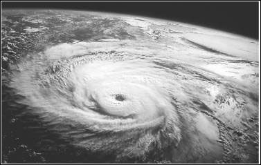
A hurricane is a type of tropical cyclone, the generic term for a low pressure system that generally forms in the tropics. A typical cyclone is accompanied by thunderstorms, and in the Northern Hemisphere, a counterclockwise circulation of winds near the earth’s surface.
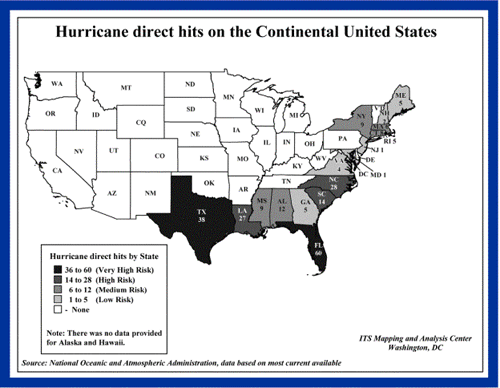
All Atlantic and Gulf of Mexico coastal areas are subject to hurricanes or tropical storms. Parts of the Southwest United States and the Pacific Coast experience heavy rains and floods each year from hurricanes spawned off Mexico. The Atlantic hurricane season lasts from June to November, with the peak season from mid-August to late October.
Hurricanes can cause catastrophic damage to coastlines and several hundred miles inland. Winds can exceed 155 miles per hour. Hurricanes and tropical storms can also spawn tornadoes and microbursts, create storm surges along the coast, and cause extensive damage from heavy rainfall.
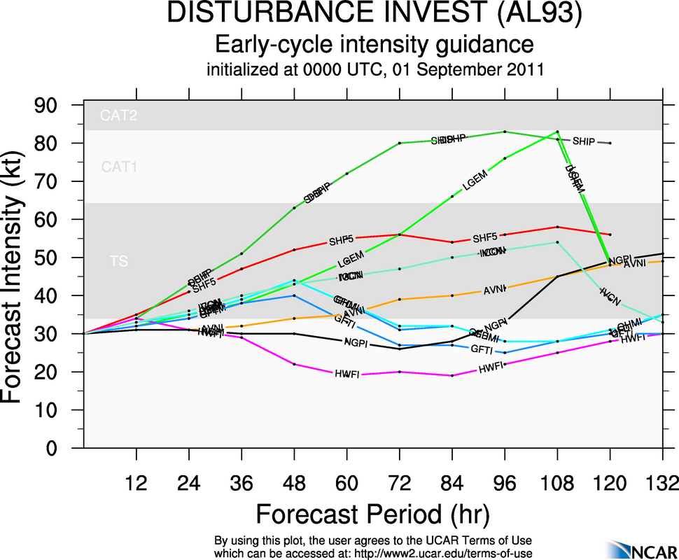
Hurricanes are classified into five categories based on their wind speed, central pressure, and damage potential (see chart). Category Three and higher hurricanes are considered major hurricanes, though Categories One and Two are still extremely dangerous and warrant your full attention.
Saffir-Simpson Hurricane Scale
Scale Number
(Category)
Sustained Winds
(MPH)
DamageStorm Surge
174-95Minimal: Unanchored mobile homes,
vegetation and signs.
4-5 feet
296-110Moderate: All mobile homes, roofs,
small crafts, flooding.
6-8 feet
3111-130Extensive: Small buildings, low-lying
roads cut off.
9-12 feet
4131-155Extreme: Roofs destroyed, trees
down, roads cut off, mobile homes
destroyed. Beach homes flooded.
13-18 feet
5More than 155Catastrophic: Most buildings
destroyed. Vegetation destroyed.
Major roads cut off. Homes flooded.
Greater than 18 feet
Hurricanes can produce widespread torrential rains. Floods are the deadly and destructive result. Slow moving storms and tropical storms moving into mountainous regions tend to produce especially heavy rain. Excessive rain can trigger landslides or mud slides, especially in mountainous regions. Flash flooding can occur due to intense rainfall. Flooding on rivers and streams may persist for several days or more after the storm.
Between 1970 and 1999, more people lost their lives from freshwater inland flooding associated with land falling tropical cyclones than from any other weather hazard related to tropical cyclones.
Map of hurricane direct hits on the continental United States
Naming the Hurricanes
Since 1953, Atlantic tropical storms have been named from lists originated by the National Hurricane Center and now maintained and updated by an international committee of the World Meteorological Organization. The lists featured only women’s names until 1979. After that, men’s and women’s names were alternated. Six lists are used in rotation. Thus, the 2001 lists will be used again in 2007.
The only time there is a change in the list is if a storm is so deadly or costly that the continued use of the name would be inappropriate for reasons of sensitivity. When this occurs, the name is stricken from the list and another name is selected to replace it.
Sometimes names are changed. Lorenzo replaced Luis and Michelle replaced Marilyn. The complete lists can be found at www.nhc.noaa.gov under “Storm Names.”
Know the Terms
Familiarize yourself with these terms to help identify a hurricane hazard:
Tropical Depression: An organized system of clouds and thunderstorms with a defined surface circulation and maximum sustained winds of 38 MPH (33 knots) or less. Sustained winds are defined as one-minute average wind measured at about 33 ft (10 meters) above the surface.
Tropical Storm: An organized system of strong thunderstorms with a defined surface circulation and maximum sustained winds of 39–73 MPH (34–63 knots).
Hurricane: An intense tropical weather system of strong thunderstorms with a well-defined surface circulation and maximum sustained winds of 74 MPH (64 knots) or higher.
Storm Surge: A dome of water pushed onshore by hurricane and tropical storm winds. Storm surges can reach 25 feet high and be 50–1000 miles wide.
Storm Tide: A combination of storm surge and the normal tide (i.e., a 15-foot storm surge combined with a 2-foot normal high tide over the mean sea level created a 17-foot storm tide).
Hurricane/Tropical Storm Watch: Hurricane/tropical storm conditions are possible in the specified area, usually within 36 hours. Tune in to NOAA Weather Radio, commercial radio, or television for information.
Hurricane/Tropical Storm Warning: Hurricane/tropical storm conditions are expected in the specified area, usually within 24 hours.
Short Term Watches and Warnings: These warnings provide detailed information about specific hurricane threats, such as flash floods and tornadoes.

For More Information

If you require more information about any of these topics, the following are resources that may be helpful.
FEMA Publications
Against the Wind: Protecting Your Home from Hurricane and Wind Damage. FEMA-247. A guide to hurricane preparedness.
Community Hurricane Preparedness. IS-324. CD-ROM or Web-based training course for federal, state, and local emergency managers.
Safety Tips for Hurricanes. L 105. Publication for teachers and parents for presentation to children. To order, call 1 (800) 480-2520.
Other Publications
Protect Your Home against Hurricane Damage, Institute for Business and Home Safety. 110 William Street, New York, NY 20038

Take Protective Measures

Before a Hurricane
To prepare for a hurricane, you should take the following measures:
  • Make plans to secure your property. Permanent storm shutters offer the best protection for windows. A second option is to board up windows with 5/8” marine plywood, cut to fit and ready to install. Tape does not prevent windows from breaking.
  • Install straps or additional clips to securely fasten your roof to the frame structure. This will reduce roof damage.
  • Be sure trees and shrubs around your home are well trimmed.
  • Clear loose and clogged rain gutters and downspouts.
  • Determine how and where to secure your boat.
  • Consider building a safe room.
Satellite image of a hurricane
During a Hurricane
If a hurricane is likely in your area, you should:
  • Listen to the radio or TV for information.
  • Secure your home, close storm shutters, and secure outdoor objects or bring them indoors.
  • Turn off utilities if instructed to do so. Otherwise, turn the refrigerator thermostat to its coldest setting and keep its doors closed.
  • Turn off propane tanks.· Avoid using the phone, except for serious emergencies.
  • Moor your boat if time permits.
  • Ensure a supply of water for sanitary purposes such as cleaning and flushing toilets. Fill the bathtub and other large containers with water.
You should evacuate under the following conditions:
  • If you are directed by local authorities to do so. Be sure to follow their instructions.
  • If you live in a mobile home or temporary structure—such shelters are particularly hazardous during hurricanes no matter how well fastened to the ground.
  • If you live in a high-rise building—hurricane winds are stronger at higher elevations.
  • If you live on the coast, on a floodplain, near a river, or on an inland waterway.
  • If you feel you are in danger.
If you are unable to evacuate, go to your wind-safe room. If you do not have one, follow these guidelines:
  • Stay indoors during the hurricane and away from windows and glass doors.
  • Close all interior doors—secure and brace external doors.
  • Keep curtains and blinds closed. Do not be fooled if there is a lull; it could be the eye of the storm - winds will pick up again.
  • Take refuge in a small interior room, closet, or hallway on the lowest level.
  • Lie on the floor under a table or another sturdy object.
After a Hurricane
Follow the instructions for recovering from a disaster in Part 5.

Real-Time Hurricane Irene Tropical Storm/50 knot/Hurricane Wind Speed Probability Images


Tropical Storm Wind Speed Probabilities

50 knot wind speed probabilities 
Hurricane Wind Speed Probabilities (Category 1 winds)
This is an automatic post, meaning that the publisher created this post earlier today and designated this post to automatically publish at a designated time because the publisher could not be near a posting area at the time. Therefore, we cannot guarantee that these images will actually be 'real-time' but will likely remain at this projection for the next couple hours at least.

Current Real-Time Track & Surface Winds, Watches/Warnings of Hurricane Irene


This is an automatic post, meaning the publisher has scheduled this post to be sent out at a designated time. Therefore, we cannot guarantee this track is 'real-time', but we can say that the track will probably not change in the next few hours.

NWS orders RAOBs to launch every six hours for Hurricane Irene

The NWS has ordered sites that launch RAOBs, or items that basically measure the atmosphere many different ways, to launch every six hours due to a trof's movement that could affect Hurricane Irene. This is a rare occurrence and details the severity of this situation.

August 25: Mandatory Evacuation Notice: Ocean City, Maryland

A MANDATORY EVACUATION FOR OCEAN CITY WILL BEGIN AT MIDNIGHT TONIGHT.

National Weather Service Forecast Offices for people affected by Hurricane Irene

A personal plea from the Publisher

To all people living along the East Coast-
I have run this blog for 16 months. I take great pride in it and hold great responsibility to myself to keep you informed.
I an begging those along the East Coast to PLEASE make preparations for a hurricane.
Warn your neighbors, friends, family.
Some will laugh at the concept of a hurricane striking the East Coast, but I am genuinely worried as a meteorologist, a forecaster, and a citizen for lives and property in the OBX areas and regions surrounding it.
Check your local forecast office from the National Weather Service, as hurricane WARNINGS have been hoisted for the East Coast.
Please heed evacuation warnings, and be safe.
-Publisher
Pack things now in the event of a flash flood from Irene or a mandatory evacuation notice along the east coast, especially near OBX.

August 25: Morning Models Shift WEST

Overnight models are now beginning the shift westward again. In the latest ECMWF and GFS, both runs shifted a bit west.
ECMWF

GFS
The isobars on the ECMWF are so tight you can't even tell if/where it makes landfall on NC. Either way, the Outer Banks area (OBX) of North Carolina will definitely be in a rough spot in this time frame, about 3 days away. If you are in the path of this storm, I am strongly advising you to consider evacuating. This storm will be the worst in 60 years as referenced by Meteorologist Jim Cantore.
NHC track

Wednesday, August 24, 2011

Hurricane Irene Mandatory Evacuation Notice: Dare County, North Carolina

A MANDATORY EVACUATION FOR DARE COUNTY, NORTH CAROLINA WILL TAKE PLACE BEGINNING AT 8 AM.

August 24 Evening Exclusive Threat Index


Irene now a Major Hurricane

Irene has reached Category 3 hurricane status as of 4:20 PM CDT August 24.
Maximum sustained winds are at 120 MPH.

August 24: Evacuation Suggestion for Outer Banks, North Carolina

The Weather Centre has officially suggested an evacuation for Outer Banks, North Carolina.
At this time... Irene's combined heavy rain, very high winds and high storm surge are very likely to devastate the Outer Banks. It is strongly advised you evacuate as soon as possible.

Hurricane Irene Models Trending Westward Again (August 24 3:30 Update)

It seems that the models forecasting for Irene are once again shifting west, towards a landfall possibly in the North Carolina/Virginia area. Let's take a look.
Here is the 12z consensus models- basically models which align into a formidable consensus point. We see the consensus keeping Irene just offshore of the East Coast and eventually impacting New England.
But here we have the new 18z consensus. Notice the sudden shift westward towards the North Carolina/Virginia region. Now, since it has only been one run of a westward shift, we are not going to answer any questions on if it will continue west. Again, it's only been one run. if the 0z models come out west again, I will get concerned. You can check out that update sometime around 9 pm CDT tonight if possible.
What we have above is the GFS model 'trends'. What that means, is that several previous tracks have been compiled into one image. The lightest blue lines indicate less recent model runs, while the nearly black line shows the most recent model run. We can see how the GFS dramatically changed course in its track for Irene on the 18z model. Now, the GFS is definitely a reliable model, adding SOME possibility the storm may go westward.
This is the consensus trends themselves. Again, lightest blue are less recent consensus results, while the darkest blue are most recent results. The consensus has shifted west as well. However, it is to be noted that the latest consensus and GFS both take sharper turns east when they are off the shores of the Carolinas.
We will keep you up to speed. Take heed of evacuation notices and suggestions from local authorities, which we will relay on our blog as well.