Radiation has been found in Chicago.
The amounts are extremely far below harmful levels- even less than what radiation a banana gives off.
Radiation has also been found in milk from 2 states.
However, the level is 5,000 times below the limit for radiation in milk.
Tests confirmed the milk is safe to drink.
In all, 15 states have detected radiation from the Japanese nuclear plant.
Sweden has also found radiation.
Mostly the coastal states have found radiation, such as Florida, Massachusetts, Colorado, California and Oregon.
Full story at CNN.com

Thursday, March 31, 2011
March 31 Severe Weather Situation
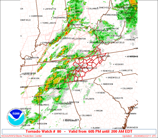
This is a multicell cluster which is not as dangerous as the single celled clusters to the west which look more potent.
Either way, there are warnings in effect as well.
Below is real-time warnings for this watch box.

Wednesday, March 30, 2011
March 30 Forecast Discussion (Until April 4)
TOMORROW
A low pressure system will be moving offshore tomorrow morning, setting the stage for an expected major snowstorm in the Northeast. Accumulations could be as high as 12 inches. On the backside of that low will be a string of 3 other low pressures. That cold create some instability in the Gulf of Mexico, but nothing major to be expected.
Dry high pressures will continue to torture the Midwest and Great Lakes, making temperatures fitting for mid-winter. That cold weather will extend into the Central and Southern Plains, though likely not as intense. However, it will likely still be an issue.
Out west into the Rockies, rain will occur in most elevations. However, there will be snow in the highest elevations. That will stem from another string of low pressures stretching from Canada into Mexico. That will also create some sprinkles around the Dakotas, hampered by the high pressures. Those sprinkles will gain momentum into the day as the low pressure system moves closer to the area.
Out in the wet and wild West, on the coast, a low pressure system will be shooting into Canada, dragging rain on its backside. The Northwest will be affected by this. However, two high pressures will be intervening to keep some areas dry for at least a morning.
A severe weather threat will exist in Florida only.
SHORT TERM (APRIL 1-2)
There will be only a small chance for severe weather going into April 1st. The main threat will likely only be small hail and periodical gusty winds.
A slingshot of low pressures will create chaos in the Northern Plains. It gives me a headache looking at all of it, so here's the image to decipher yourself. This image is for April 1.
 LONGER RANGE (UNTIL APRIL 4)
There's a lot to talk about, but in the interest of time, i will give a summary.
4 days away, we can expect a developing severe weather event that will lead into Day 5, when a significant severe weather outbreak is still predicted. We will keep an eye out.
A low pressure system will be moving offshore tomorrow morning, setting the stage for an expected major snowstorm in the Northeast. Accumulations could be as high as 12 inches. On the backside of that low will be a string of 3 other low pressures. That cold create some instability in the Gulf of Mexico, but nothing major to be expected.
Dry high pressures will continue to torture the Midwest and Great Lakes, making temperatures fitting for mid-winter. That cold weather will extend into the Central and Southern Plains, though likely not as intense. However, it will likely still be an issue.
Out west into the Rockies, rain will occur in most elevations. However, there will be snow in the highest elevations. That will stem from another string of low pressures stretching from Canada into Mexico. That will also create some sprinkles around the Dakotas, hampered by the high pressures. Those sprinkles will gain momentum into the day as the low pressure system moves closer to the area.
Out in the wet and wild West, on the coast, a low pressure system will be shooting into Canada, dragging rain on its backside. The Northwest will be affected by this. However, two high pressures will be intervening to keep some areas dry for at least a morning.
A severe weather threat will exist in Florida only.
SHORT TERM (APRIL 1-2)
There will be only a small chance for severe weather going into April 1st. The main threat will likely only be small hail and periodical gusty winds.
A slingshot of low pressures will create chaos in the Northern Plains. It gives me a headache looking at all of it, so here's the image to decipher yourself. This image is for April 1.

There's a lot to talk about, but in the interest of time, i will give a summary.
4 days away, we can expect a developing severe weather event that will lead into Day 5, when a significant severe weather outbreak is still predicted. We will keep an eye out.
March 30 Severe Weather Bulletin
CAPE values have dropped after the passage of a small squall line, meaning the atmosphere is stabilizing.
That said, it can be expected the storms about to move onshore will either slightly strengthen, sustain at their current strength, or drop in strength.
All in all, the severe storms seem to have maxed out.
I am expecting elevated storms at best.
That said, it can be expected the storms about to move onshore will either slightly strengthen, sustain at their current strength, or drop in strength.
All in all, the severe storms seem to have maxed out.
I am expecting elevated storms at best.
Severe Weather Center coming soon
The page is down for major renovations and will be back online by 8 pm CDT tonight.
Tuesday, March 29, 2011
March 29 Forecast Discussion (Until April 3)
TOMORROW
Tomorrow, we will watch two low pressure systems, connected by a trough, slide across the Southeast. In the process, they will create some severe weather as they are creating right now. The lows will eventually combine, then connected by a front. That will intensify these storms.
As they make their way across the board, the low level jet stream will be following their lead. The atmosphere will be unstable from the Gulf up.
Around Pennsylvania, some snow will occur as the precipitation from an extending trough moves towards the coast. The accumulations will be light.
Dry high pressures over the Plains back into the Great Lakes will keep the region cold and sunny, a combination designated for winter.
A low pressure system over the Rockies will be connected to another low in New Mexico. That will be connected to yet another low in Mexico. In all, they will produce light precipitation.
SHORT RANGE (MARCH 31)
The strong low pressures will move off the Eastern Seaboard after soaking the region. A section of snow and icy conditions will travel up the Northeast. Again, accumulations will be light.
Low pressure will move out of the Rockies, creating abundant precipitation. It will be in the form of mostly rain.
Severe weather will be confined to the state of Florida only. As if they haven't had enough to deal with. Anyways, it appears unlikely that a multi-cell cluster will develop. The same goes for a squall line. At best, several strong, single-celled storms will develop in Central Florida. I would expect a couple of tornadoes at best, but strong winds and small hail are the primary threat.
LONGER RANGE (UP TO APRIL 3)
The Storm Prediction Center is carefully eyeing the Plains for a significant severe weather event. That would occur beyond this forecast's range, but it is something worth mentioning. Because, at the words 'significant severe event', there is a larger concern than just a regular severe weather risk.
A warm-up will occur into the April 2nd period over the Northwest. However, low pressure clippers from Canada will keep the Great Lakes region cold. The Northeast will also be cold.
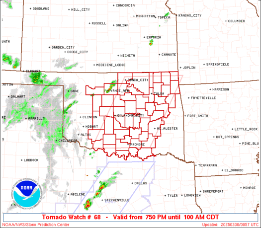
March 29 Severe Weather Situation
Severe storms are developing in Southern Texas into Louisiana. There are actually 2 severe weather situations, but we will focus more on the tornado watch. Below is an image of real-time radar of that watch.
 This watch goes until 10:00pm CDT.
This watch has been issued as single-cell storms have developed into a loosely organized cluster. These storms are generating warnings, and below are those warnings.
 The low level jet stream is working its magic across the region, giving the atmosphere a kick of instability. That explains the CAPE values of instability have surpassed 3000 j/kg. That means the atmosphere is at a very good degree of instability.
However, it does appear there isn't much lift within this storm environment.
Vorticity maps indicate that there is negative vorticity, while positive vorticity indicates areas suitable for storm development. Tornadoes are not incredibly likely
But, the Surface Based Lifted Index is at -8, indicating major instability.
This watch has been issued as single-cell storms have developed into a loosely organized cluster. These storms are generating warnings, and below are those warnings.
However, it does appear there isn't much lift within this storm environment.
Vorticity maps indicate that there is negative vorticity, while positive vorticity indicates areas suitable for storm development. Tornadoes are not incredibly likely
But, the Surface Based Lifted Index is at -8, indicating major instability.
Monday, March 28, 2011
March 28 Forecast Discussion (Until April 2nd)
TOMORROW
Tomorrow, we will be watching the South Plains for severe thunderstorms. This comes as two low pressures connected by fronts cross the Southern United States.
It appears the low level jet stream will be actively pumping humid Gulf air into the atmosphere, thus destabilizing the atmosphere itself. The reason there is a right to believe there will be a severe weather outbreak is how evident that essential low level jet stream will be. Precipitable water (water values in the air) will go past 1 inch of water in the air. I would like to expand the severe weather risk across a larger area of the Southern Plains just due to that, so we will have to keep an eye on everything. This comes on the latest 18z GFS run.
In other news, a low pressure system across the Central Plains will bring snowfall to the region, especially on the eastern side of the low pressure area, which should be located on the extreme western region of Nebraska. Accumulations are expected to be at a maximum of 4 inches, especially in the intersection of the Iowa/Nebraska/South Dakota borders.
A trough moving across the Southeast may create some clouds, but only a sprinkle at best. However, down in South Florida, there will be a watchful eye cast on that area as heavy rains and storms are poised to strike. However, it does not look like it will be a severe weather situation.
SHORT-TERM FORECAST (UNTIL MARCH 30)
In the way of severe weather risks, we will see a widespread but low risk of severe weather in the Southeast. The Storm Prediction Center currently has that area out looked for only a 5% risk of severe storms, which says that, at best, isolated to scattered severe storms may occur. Elevated storms are more of a possibility. The creator of all this precipitation will be a strong low pressure with a classic severe storm set-up. A cold front will extend somewhat directly south, with a warm front horizontally to the east. That said, some elevated storms could occur in the Gulf of Mexico. The low level jet stream will be pumping warm, humid air straight into the mouth of the beast.
Otherwise, a warm front will create a mix of precipitation in the Central Plains going into the 30th.
A very strong low pressure system will slam the West Coast with a true wash-out. It will get ugly in lower elevations with heavy rains, accompanied by snows in the Mountains.
LONG-TERM FORECAST (UNTIL APRIL 2)
The Storm Prediction Center has outlined a severe weather outbreak in Florida only. In that area, the SPC indicates an influx of Gulf moisture will create an unstable atmosphere. This will be due to the low level jet stream, creating moisture values of up to 1.75 inches of water in the air. A cold front will provide for a classic severe weather outbreak. As that moves through, strong vertical shear will inspire supercell storms and bow echo storms to develop. In such an unstable environment, a tornadic situation is certainly not out of the question. Strong shear with instability is a ripe environment for tornadoes. We will definitely have to watch this situation for tornadoes.
Sunday, March 27, 2011
March 27 Tomorrow's Forecast

That occluded front will trail back to a low pressure system in New Mexico. It will be creating precipitation in the Rockies, as will another low pressure system north of the first.
Snow and icy conditions will exist in the Rockies with rain in lower elevations.
The West Coast will finally get a break with only rainy conditions in slight areas.
Strong low pressure off the coast off Washington State will create clouds.
Strong high pressure will pump cold air into the Midwest, Plains and Great Lakes.
Snow showers will exist in the Northeast.
The Southeast will be somewhat cooler after the showers and storms, as is expected.
Storms in South Georgia to Fade
Storms currently occurring in South Georgia will be fading through this evening without the support of the lower level jet stream. Click here for a Weather Explained article on the lower level jet stream.
The lower level jet stream is currently located in North Georgia and not supporting the storms to the south.
However, should any storms develop in North Georgia, those may be an issue.
The lower level jet stream is currently located in North Georgia and not supporting the storms to the south.
However, should any storms develop in North Georgia, those may be an issue.
Weather Explained: Lower Level Jet Stream
What is a lower level jet stream?
It is a river of fast moving air in the lower level of the atmosphere, while toe big jet streams are in the higher atmosphere.
What does it do?
In the spring-summer time, the lower level jet stream will amplify itself and storms around it in the Plains at nighttime, explaining why storms are sometimes stronger at night.
It can rapidly transport moisture and warm temperatures from the Gulf of Mexico north.
So the only thing it does is use wind to make storms stronger at night?
With the rapid transport of moisture, it is able to quickly pump up storms and feed it until the jet moves away.
What does it look like?
 The white area is the lower level jet stream.
It is a river of fast moving air in the lower level of the atmosphere, while toe big jet streams are in the higher atmosphere.
What does it do?
In the spring-summer time, the lower level jet stream will amplify itself and storms around it in the Plains at nighttime, explaining why storms are sometimes stronger at night.
It can rapidly transport moisture and warm temperatures from the Gulf of Mexico north.
So the only thing it does is use wind to make storms stronger at night?
With the rapid transport of moisture, it is able to quickly pump up storms and feed it until the jet moves away.
What does it look like?

Storms in the Southeast raising Concern
A line of what may be supercells in the Southeast are raising concern after wind shear values indicate that rotation in storms is not out of the question.
Below is the radar image along with risks from the SPC.
 Those storms have been intensifying. Below is also the severe thunderstorm watch issued for these storms.
 Almost like a rash, these storms are striking across the Southeast. Judging how they are singular-celled, they do have a slightly higher potential for tornadic activity. Below are current warnings within the watch area.
 While tornado probabilities are low, isolated tornadoes cannot be ruled out due to the wind shear. The wind shear is over what is needed for reasonable thinking of supercell formation.
We will be monitoring this.
Below is the radar image along with risks from the SPC.
We will be monitoring this.
Saturday, March 26, 2011
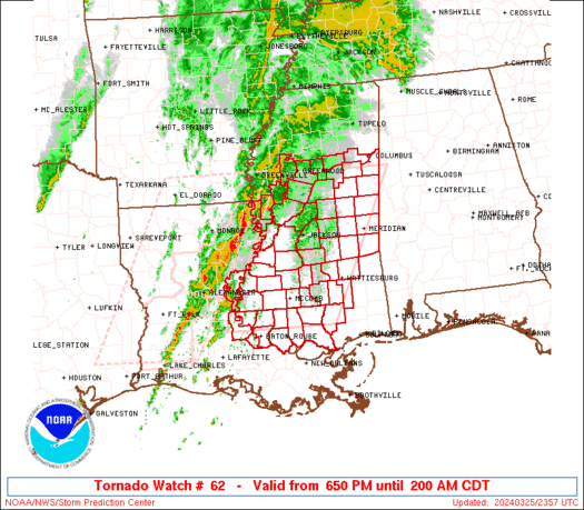
March 26 Strong Supercell Concern
There is a real concern in the Texas area due to a singular supercell that may turn violent at any moment.
Some indicators of this are the following:
-Craven/Brooks Significant Severe weather indicator are 3 and a half times the amount needed to begin reasonable probabilities for significant severe weather.
-Effective Bulk Wind Shear (what is needed for tornadoes due to winds in different directions) are 2 times the amount minimally needed for probability of supercells.
-CAPE values are 1000 j/kg above what makes the atmosphere considered unstable. Also an indicator of energy in the atmosphere.
-Lifted Index is at -9, while values under -6 are classified as extremely unstable. Severe storms are likely with a lifting mechanism.
-CAPE Downdraft values are off the charts, meaning downdrafts from clouds are likely.
Overall, this is a very intense situation.
Below is real-time radar image of these supercells.
March 26- Tomorrow's Forecast

On the north end of the string of low pressures will be some snow. Accumulations are not expected to be significant. Just to the west will be some icy conditions, but those are not expected to be significant, either. We will definitely watch that area tomorrow.
Out west, more low pressure systems will create more snow in the Rockies. On the West Coast, rain will be found as a low pressure off the shore, just to the north and out east will surround the Northwest.
In the Plains will be some icy conditions and snow showers mixed in as temperatures hover around freezing.
Out in the Northeast will be some snow showers.
Trough/Dry Line Poses Concerns
A trough associated with a low pressure system is creating a possible dry line in Texas. Below is a visible satellite imagery at time of publishing.
 In Texas, we definitely see a line separating what appears to be dry air and moist air. Should that be a dry line, a severe weather situation would definitely be possible.
Wind shear indicates that any storms that develop would have potential to have rotation.
CAPE values are at 3000 around a section of this trof/dry line, so any storms developing could pose a serious tornadic risk.

Wind shear indicates that any storms that develop would have potential to have rotation.
CAPE values are at 3000 around a section of this trof/dry line, so any storms developing could pose a serious tornadic risk.
POTENTIALLY DANGEROUS SITUATION March 26
This is a PDS.
AS OF 1:08PM CDT, THE STORM PREDICTION CENTER HAD OUTLINED A PORTION OF THE SOUTHEAST IN A MODERATE RISK OF SEVERE STORMS.
BELOW IS RADAR IMAGERY AS WELL AS CURRENT RISKS.
SUPERCELLS ARE BEGINNING TO DEVELOP. SUPERCELLS ARE THE MAIN CAUSE OF TORNADOES. A TORNADO WATCH HAS BEEN ISSUED FOR A LARGE PORTION OF THE SOUTHEAST AS SEEN BELOW. IT EXPIRES AT 8PM CDT.
 ANYONE IN THIS WATCH BOX SHOULD PREPARE FOR:
-TORNADOES
-ISOLATED STRONG TORNADOES
-VERY LARGE HAIL
-DAMAGING WINDS
AS OF 1:08PM CDT, THE STORM PREDICTION CENTER HAD OUTLINED A PORTION OF THE SOUTHEAST IN A MODERATE RISK OF SEVERE STORMS.
BELOW IS RADAR IMAGERY AS WELL AS CURRENT RISKS.
-TORNADOES
-ISOLATED STRONG TORNADOES
-VERY LARGE HAIL
-DAMAGING WINDS
March 26 Today's Forecast
SOUTHEAST
Showers and thunderstorms currently ongoing are expected to possibly redevelop and intensify over an area of the Southeast where severe weather is possible today.
SOUTH CENTRAL
Some of the precipitation from those Southeast storms will develop from a low pressure system associated with the other system forming the severe weather.
SOUTHWEST
The Southwest should be fine except for a West Coast storm that may cause some sprinkles and showers the closer you get to the Coast.
NORTHWEST
The Northwest will be soggy and gross with another low pressure system off the West Coast.
NORTH PLAINS
Snowfall will occur, associated with a low pressure system. It could be heavy at times, with accumulations up to 6 inches.
MIDWEST
Some rain will occur in the far south Midwest. Otherwise, a Canadian high pressure will keep the area cool.
NORTHEAST
High pressure will keep the area dry.
Friday, March 25, 2011
March 25 Tomorrow's Forecast Discussion

 |
| Both images from RAP Weather |
Until tomorrow morning. Significant pressure differences to start with will provide some ignition for these storms. The tornado risk indicates some tornadoes should occur, as well as a significant hail event. A strong lifting mechanism will be needed.
The reason tornadoes may be likely is due to a high Bulk Shear- Effective value. If the values are between 25-40 knots, that is when supercell probabilities begin to start. In recent times tonight, even before the supposed outbreak, the Bulk Shear was up to 55 knots in some places of the severe weather risk area. By the way, that risk area is in Southeast Oklahoma into South Arkansas. Below is an image of that risk area.
As stated below, temperature differences over the South Arkansas area could make the scene intense. We will definitely have to watch this unfold as it may happen into the early morning hours.
Back in the Rockies, low pressure will create for a mix of snow and icy conditions across the mountainous region. Avalanche risks may be on the rise, so be careful if you ski in those areas.
A strong low pressure off the coast of Washington will create yet another messy day tomorrow. It will be carrying an occluded front. That said, the atmosphere is expected to be somewhat capped, limiting some thunderstorms. However, with the ocean moisture, this will be hard to tell.
Temperatures will be cool to cold across the northern tier of the US.
March 25 Severe Weather Update 7:08pm
According to recent infrared imagery, cloud cover is deepening over the projected severe weather area in South Arkansas and Southeast Oklahoma.
Radar does not indicate any precipitation is currently falling, but it does appear updrafts of humid air into the atmosphere, creating clouds are beginning to occur.
Thus, The Weather Centre is issuing a discussion image.
 Recent upper-air returns also indicate humidity values are extremely abundant throughout the area noted, and precipitation that falls will be fed nicely with the moisture.
Effective Bulk Shear is in the 50-55 knot range, when supercell favoring environments begin at 25-40 knots.
However, 300 millibar upper air maps are showing fairly low winds. (300 mb winds, when above 100 knots on a map, can indicate storm development.) The maximum winds currently occurring over the above area are between 70-110 knots. However, the outlined area is on the edge of those winds, likely putting that area in the 70-90 knot area.
Overall, some ingredients are not in place for storms.
Radar does not indicate any precipitation is currently falling, but it does appear updrafts of humid air into the atmosphere, creating clouds are beginning to occur.
Thus, The Weather Centre is issuing a discussion image.

Effective Bulk Shear is in the 50-55 knot range, when supercell favoring environments begin at 25-40 knots.
However, 300 millibar upper air maps are showing fairly low winds. (300 mb winds, when above 100 knots on a map, can indicate storm development.) The maximum winds currently occurring over the above area are between 70-110 knots. However, the outlined area is on the edge of those winds, likely putting that area in the 70-90 knot area.
Overall, some ingredients are not in place for storms.
Notice 3/25
Exciting Changes will be occurring at The Weather Centre in the upcoming days ahead.
As we transition into the severe weather season, specialized maps will be coming out detailing severe weather risks.
The names are not yet known, but they will be very modern and informative.
As we transition into the severe weather season, specialized maps will be coming out detailing severe weather risks.
The names are not yet known, but they will be very modern and informative.
March 25 Severe Weather Outlook Today


This severe weather event is not projected to be significantly severe. Looking at the top image from the NOAA, there is only a small area of severe weather forecast. Looking at the RAP Weather image, the low pressure will be aligned in Arkansas with that area of rain intensifying.
The trough may be the ignition for the storms. However, there is also the possibility the cold front will catch up to the warm front and create severe weather. We will just have to wait and see.
Below is the overall SPC risk area for today.


The tornado risk is somewhat elevated, potentially due to that lift. The wind risk is not abnormal but may also be enhanced by the lift. It seems to all come down to the lift.
March 25 Rest of the Day Forecast


There will be a risk of severe weather today which will be outlined in a post soon. It does appear a warm front will be the result of the severe weather.
Today, warm temperatures will exist across the South US, but accompanied with clouds as the low pressure passes.
Low pressures over the Rockies will create mountain snows and rain in lower elevations. A storm off the West Coast will also begin to create problems along that area.
Thursday, March 24, 2011
March 24 Tomorrow's Forecast Discussion


Light snow will occur in the Great Lakes.
Temperatures will be nice and warm in Texas and Florida, with temperature differences along the low pressure area in the Plains. Cool temperatures will exist in the Northern tier of the US.
March 24 Severe Weather Discussion for Tonight


Will be monitoring this situation.
Weather Explained: Types of Weather Fronts

1. Cold Front- A front with a following cold air mass.
2. Warm Front- A front with a following warm air mass.
3. Stationary Front- A front that is literally not moving.
4. Occluded - When a cold front overtakes a warm front. Usually, an air mass dries when an occluded front passes.
5. Trough- An elongated region of low pressure, usually associated with fronts.
6. Squall - A line of severe storms ahead of a cold front.
7. Dry Line- Separates humid air to the east and dry air to the west.
8. Tropical Wave
March 24 Surface Analysis Severe Weather

Low pressure by New Mexico is currently dragging a warm front across the West Texas. This warm front is creating a single cell across West Texas as the warm front passes through. The bigger concern will be as the cold front slowly accompanies the warm air.
Right behind the warm front is a trough which will likely be the ignition for these storms due to how localized the length of the troughs are.
Rest of Tonight Forecast- March 24


The temperatures did dip quite a bit across the northern tier of the United States thanks to the low pressure system and following cold front. However, there were nice and warm spots across the south US, which was pretty much the only place you could find into the 80's.
So that's a wrap up of tonight's forecast.
Radiation found in Oregon, Hawaii and Colorado
Radiation was found in Oregon and Colorado, as well as Hawaii.
Monitors in a nationwide network detected traces of radioactive iodine.
They join Washington State and California in states found with Radiation.
Let me stress this to you.
These traces of radiation are 100,000 times less than what you get from natural radiation, such as bricks, the sun and rocks.
Even the natural radiation doesn't cause horrible issues.
The only time to take action is if you live within 20 miles of the actual nuclear plant.
Wednesday, March 23, 2011
March 23 Tomorrow's Forecast Discussion


FORECAST DISCUSSION
The above image is obviously new, and it is directly from the NOAA. We will display the predominant weather and temperatures instead of other stuff that is hard to understand. The images are 24 hours out from now.
Let us begin.
A minor snowstorm in a pattern of unsettled weather will occur in the Plains. In this image, this could be a potential for a maximum of a couple of inches of snowfall accumulations. Additionally, temperatures will hover around 30, so some transitions will happen around the beginning of the storm. Below the mixing area, some light rain will occur. The mixing area will be somewhat dangerous, with freezing rain being a potentially dangerous issue. Will have to watch for this.
Some light snow will continue in the Northeast with temperatures around the 20's.
Down in the south, all should be well with temperatures into the 80s. There will be some sprinkles and fog.
There will be a major West Coast storm igniting fears of flooding and landslides. Rain in the lower elevations and snow in higher elevations.
March 23 Tornado Watch Box #1
At this time, a large tornado watch has been issued. See below for the imagery of radar and the watch box combined.
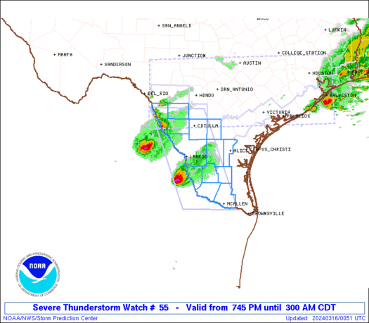
This watch is effective until 9 pm EDT/8 pm CDT. The storms pictured above will be on the increase as the chance for supercells increases throughout the day. Check your local radar for information on this developing storm.
Upper Midwest Blizzard Totals March 23

Light Blue: 1-2''
Dark Blue: 2-3''
Green: 3-4''
Yellowish Green: 4-5''
Yellow: 5-6''
Pinkish Red: 6-7''
Darker Pinkish Red: 7-8''
Red: 8-9''
Maroon: 9-10''
Light Pink: 10-11''
A bit darker pink: 11-12''
Still darker: 12-13''
March 23 Severe Weather Overview- Today
There will be a severe weather outbreak over the Ohio Valley today.
The Storm Prediction Center has upped the risk to Moderate in the Ohio Valley, indicating the storms will be worse or more widespread than previously thought. Either way, today is definitely a day to monitor.
First, we will start off with the Storm prediction Center's overall risk.
 Above we do see that area of moderate risk in the Ohio Valley, pretty much centered in East Kentucky and West Virginia (the state West Virginia). There is also a slight risk of severe storms surrounding that moderate risk through the rest of Kentucky, Tennessee, Virginia, Ohio and Indiana.
Based on the formation of the risk areas, I do not believe this will be a squall line. Rather, pop-up storms combining into a multi-cell storm complex seems most reasonable.
Next, let's check out the specific risks.
This above image is the tornado outlook. Let's do a comparison. Yesterday, Iowa had a 10% chance for tornadoes. As a result, around 16 tornadoes occurred. Comparing that to a broad area of 5% would indicate that there does appear to be decent potential for scattered tornadoes. I cannot rule out one stronger tornado. Next, we will take a look at the hail risk.
This hail risk was the single threat to ignite the moderate risk area in the first image. The 45% area indicates that widespread damaging, large hailstones will fall. The hatched (dashed lines) area also indicates that. Based on the fact that a lifting mechanism is needed to produce hail, it can be assumed that a strong lifting mechanism will be in place to produce such hail. Next image will be damaging winds.
The wind risk, although large, did not set off the moderate risk in the Ohio Valley. As mentioned above, a strong lifting mechanism in the clouds will be lifting up raindrops over and over again to produce hail. In some cases, strong wind bursts called downdrafts will come out of the clouds. Another name for this is a microburst, but the correct term is downdraft, due to the potential for a broad area of the downdraft. Anyhow, that lifting mechanism may release damaging wind downbursts and/or create strong surface winds due to the strong lifting in the atmosphere.
Other Concerns...
The Storm Prediction Center's outlook indicates supercells and fast moving line segments will develop. Notice how I said supercells with an S. The SPC does expect multiple cases of these to develop. Supercells produce tornadoes in the first place, so this enhances the tornado threat.
Also, CAPE values could rise to 1500 j/kg, just under the 2000 j/kg typical of the threshold for producing severe storms.
Any updates on this situation will be posted as warranted.
The Storm Prediction Center has upped the risk to Moderate in the Ohio Valley, indicating the storms will be worse or more widespread than previously thought. Either way, today is definitely a day to monitor.
First, we will start off with the Storm prediction Center's overall risk.

Based on the formation of the risk areas, I do not believe this will be a squall line. Rather, pop-up storms combining into a multi-cell storm complex seems most reasonable.
Next, let's check out the specific risks.
Other Concerns...
The Storm Prediction Center's outlook indicates supercells and fast moving line segments will develop. Notice how I said supercells with an S. The SPC does expect multiple cases of these to develop. Supercells produce tornadoes in the first place, so this enhances the tornado threat.
Also, CAPE values could rise to 1500 j/kg, just under the 2000 j/kg typical of the threshold for producing severe storms.
Any updates on this situation will be posted as warranted.
Tuesday, March 22, 2011
March 22 Forecast Discussion

Additionally, with a defined warm front area, storms will be likely across the cutoff of the warm front on the East Great Lakes.
Cold air will be dragged down from Canada following the cold front and storms. The cold air will try to wrap around the low pressure but will run into the stronger force of the warm air. I would not be surprised to see some storms develop in those areas as well.
High pressure in the Rockies will keep that area high and dry, however low pressure off the Northwest coast will keep some areas wet and cloudy, a common climate for that area.
Intense blizzard across the Upper Midwest will move off and go into the Eastern Great Lakes.
March 22 Current Thinking
This Current Thinking is due to the severe weather occurring out west.
These storms HAVE already produced MULTIPLE tornadoes.
However, these storms are weakening.
Wind shear is holding these storms together, thus also keeping an isolated tornado chance in play for likely much of the night.
Should current thinking continue, hail chances would reign as the main threat as this storm complex goes into the Midwest more.
A squall line has developed, and it is moderately strong at this time.
It is unknown if this is the peak strength or if it will increase.
We will see as it goes on.
POTENTIALLY DANGEROUS SITUATION MARCH 22
This is a PDS bulletin.
PARAMETERS INDICATING EXTREMELY SEVERE WEATHER ARE RISING TO HIGH LEVELS.
BELOW IS THE CRAVEN/BROOKS SIGNIFICANT SEVERE WEATHER PARAMETER. VALUES ABOVE 20 (20,000) ARE CONSIDERED CORRECT CONDITIONS FOR SIGNIFICANT SEVERE WEATHER.
 VALUES AT 90,000 ARE CONSIDERED EXTREMELY DANGEROUS.
NEXT, WE WILL SEE THE SIGNIFICANT TORNADO PARAMETERS. VALUES GREATER THAN 1 ARE FAVORABLE FOR SIGNIFICANT TORNADOES WITHIN THE HOUR.
 WE SEE THE VALUES AT 3, INDICATING A DANGEROUS SITUATION.
FINALLY, WE WILL SEE LAPSE RATES. VALUES UP TO 9.5 ARE ABSOLUTELY UNSTABLE IN THE ATMOSPHERE.
 IF YOU ARE IN ANY OF THESE DANGEROUS AREAS IN THESE IMAGES, PREPARE AT ANY TIME TO TAKE IMMEDIATE COVER.
PARAMETERS INDICATING EXTREMELY SEVERE WEATHER ARE RISING TO HIGH LEVELS.
BELOW IS THE CRAVEN/BROOKS SIGNIFICANT SEVERE WEATHER PARAMETER. VALUES ABOVE 20 (20,000) ARE CONSIDERED CORRECT CONDITIONS FOR SIGNIFICANT SEVERE WEATHER.

NEXT, WE WILL SEE THE SIGNIFICANT TORNADO PARAMETERS. VALUES GREATER THAN 1 ARE FAVORABLE FOR SIGNIFICANT TORNADOES WITHIN THE HOUR.

FINALLY, WE WILL SEE LAPSE RATES. VALUES UP TO 9.5 ARE ABSOLUTELY UNSTABLE IN THE ATMOSPHERE.

March 22 Heavy Snow Potential Special Bulletin
This is a special bulletin about a potentially heavy snow period for about 3 hours in North Wisconsin.
Below is an image from the University of Illinois Ensembles.
 This is maximum reflectivity, meaning that is the most that would show up on radar. Notice how intense that is in Wisconsin. That could pose some extremely serious problems.
However, we must also know what the predicted AVERAGE is supposed to be.
Below is the average of that same member of what the average is supposed to be.
 Even so in the average above, it is still a dangerous situation.
Please be careful out there tonight, as Duluth is supposed to receive over 1 foot of snow in a blizzard.
Below is an image from the University of Illinois Ensembles.

However, we must also know what the predicted AVERAGE is supposed to be.
Below is the average of that same member of what the average is supposed to be.

Please be careful out there tonight, as Duluth is supposed to receive over 1 foot of snow in a blizzard.
March 22 Severe Weather Overview- Happening Now
This is an overview of the severe weather due to happen over the course of today.
We will start with how unstable the atmosphere will be, since that plays a big role in severe storms.
BEST LIFTED INDEX
The Best Lifted Index was very surprising this morning. Values of this sort are usually found around in Mexico. Below is the latest image of right now from the RUC.
 First off, notice the value of -12 out in Iowa. That is an extremely delicate situation. Should severe storms enter that area with the value of -12, I would definitely expect very large hail and strong tornadoes. Luckily, that will not happen. It may happen this evening, but not right now.
Let's fast forward 12 hours to when the severe weather is projected to actually happen.
 First off, we do see a weak definition of a squall line. However, the SPC actually cut off the tail end of the outlook, leading me to less and less believe the idea of a squall line throughout the Plains and south central US. It looks more like a small squall line as well as clusters of disorganized storms.
Anyhow, it appears values of -6 and -4 will be in the severe area. Main concern will still be in Iowa, where maximum values appear to be -8. Overall, this is definitely a situation to watch for Iowa.
LAPSE RATES
Another indicator of instability is lapse rates. Remember, values at 9.5 are 'absolutely unstable'. Below is the RUC image form right now at the time of publishing.
 Lapse rates are temperature drops with height. We see an extremely unstable situation in Nebraska at this time, with values from 8.5 to 9 degrees.
Next, let's fast forward 12 hours to the severe weather time frame.
 These values aren't very impressive where the storms are forecast to occur. However, still back in Iowa and Nebraska, the lapse rates will remain very high and unstable.
FORECAST RADAR REFLECTIVITY
This is basically what the radar is forecast to look like in the near future. Let's take a look 10 or 12 hours in the future using the RUC to see what the storms will look like.
 That line extending south was actually a weak squall line in hour 10. However in this image, hour 12, we see the storms only beginning to affect the area. This RUC method has been right in some situations while wrong in others. However, this looks like a good bet, but I would add in areas of yellow if I could to this image. Below is an animation of a WRF run from Wright Weather.
 This animation is an overall good tool to use as a predicted radar lookout 48 hours in the future.
STORM PREDICTION CENTER'S OUTLOOK
So these are the SPC's outlooks for today's severe weather. The images, in order, are the overall risk, hail risk, tornado risk, and damaging wind risk.


 It appears to be no coincidence that the tornado risk and damaging wind risks are in the same areas, as atmospheric turbulence can create damaging surface winds as well as violent tornadoes. The Hail risk is also most concentrated in the wind/tornado threat, leading me to believe any storms that develop in that area will have strong lifting, meaning it will be able to throw water droplets high enough into the air to freeze into hail. That hail risk also extends into Illinois and the Southern Great Lakes. It appears that, although that lifting mechanism will weaken as the complex moves off, that lift will remain able to generate small hail.
This has been an overview of a Happening Now situation. These are issued when a weather event is due to happen today.
We will start with how unstable the atmosphere will be, since that plays a big role in severe storms.
BEST LIFTED INDEX
The Best Lifted Index was very surprising this morning. Values of this sort are usually found around in Mexico. Below is the latest image of right now from the RUC.

Let's fast forward 12 hours to when the severe weather is projected to actually happen.

Anyhow, it appears values of -6 and -4 will be in the severe area. Main concern will still be in Iowa, where maximum values appear to be -8. Overall, this is definitely a situation to watch for Iowa.
LAPSE RATES
Another indicator of instability is lapse rates. Remember, values at 9.5 are 'absolutely unstable'. Below is the RUC image form right now at the time of publishing.

Next, let's fast forward 12 hours to the severe weather time frame.

FORECAST RADAR REFLECTIVITY
This is basically what the radar is forecast to look like in the near future. Let's take a look 10 or 12 hours in the future using the RUC to see what the storms will look like.

STORM PREDICTION CENTER'S OUTLOOK
So these are the SPC's outlooks for today's severe weather. The images, in order, are the overall risk, hail risk, tornado risk, and damaging wind risk.


This has been an overview of a Happening Now situation. These are issued when a weather event is due to happen today.
Subscribe to:
Posts (Atom)