Monday, May 21, 2012

Tropical Depression May Eventually Landfall as Hurricane in Mexico

Tropical Depression Two-E has formed in the east Pacific. It looks to rapidly intensify into a tropical storm today, before becoming a hurricane late Tuesday. The HWRF shows it landfalling with over 120 knot winds, as seen below.

130 knots is the equivalent of 150 MPH, which would actually be a Category 4 hurricane. It's pretty safe to say that that solution probably won't happen going up against the NHC track, but I will keep an eye on it.

More later this afternoon.

Sunday, May 20, 2012

Severe weather update

I'm outside checking out the situation for severe weather. Snapping pictures, waiting for the storms to roll in.
From what I've seen, many cumulus clouds are now actually able to build, hence the storms.

Andrew

Eastern Wisconsin, North Illinois in Severe Risk Today

Eastern Wisconsin, North Illinois and the northern section of Michigan are within the realm of severe weather potential for today, as a cold front is expected to sweep through the area and provoke strong to potentially severe thunderstorms. Hail and damaging winds will be the main threats.

The Rapid Refresh (RAP) model is showing several clusters of showers and storms in Illinois, Missouri around the 5:00 hour (PM, CDT) tonight. Looking over instability values, these showers and storms should be supported fairly by 1000-2000 j/kg of CAPE. It should be noted that the HRRR, which is the High Resolution Rapid Refresh, has been increasing shower and thunderstorm coverage in the timeframe mentioned above. You can find more updates on our Facebook page at www.facebook.com/TheWeatherCentre

Andrew

Alberto to Shift Out to Sea in Coming Days

Alberto remains at tropical storm status, however does appear to be fairly weak, with this imagery detecting the strongest part of the storm on the western side, leaving the eastern side fairly exposed to the elements of nature. However, Alberto does look to keep tropical storm strength as it makes a 180 and heads northeast along the East Coast.

These are called dynamic models, which are models that take the information from buoys and surface data near the storm, unlike statistical models, which rely on historical tracks. The dynamic models are projecting a close brush with North Carolina which would likely result in minor beach erosion and weak storm surge from intense waves. After that, the system looks to either go out to sea, or actually pose a threat to New England. That will definitely have to be monitored in coming days.

Andrew

Saturday, May 19, 2012

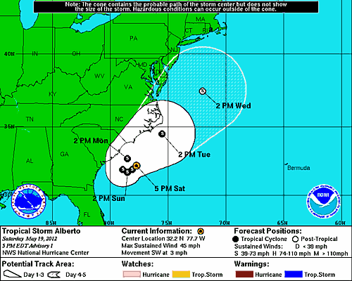
Tropical Storm Alberto to Hug East Coast

Tropical Storm Alberto is projected to make a u-turn and head northeast along the East Coast, posing threats to both Carolinas over the next few days before heading towards New England. Right now, I would guess, based on historical tracks, that this storm will likely miss the New England area and head towards the far north Atlantic areas. However, the Carolinas remain in the potential target zone and will have to be monitored.

Probabilities for tropical storm winds are mainly the highest out offshore the Carolinas, but the NHC has designated South Carolina with a 30% - 40% chance of tropical storm winds.