Overall Risk:
The Storm Prediction Center upped the risk from Slight to Moderate in Northwest Missouri into East Kansas. The reason for that is not tornadoes, but for a threat of hail. That image will be shown below.
The next image will be the threat for large hail.
In the above image, we see the region of hail threat that sparked the moderate risk area. With that in mind, it can be expected storms with strong lifting will occur, lifting the raindrops up into the air, high enough to create hail.
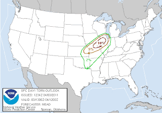
The next image will be the tornado outlook.
The tornado risk above is aimed more towards North Illinois than anyone else. The Weather Centre indicates this goes along with Significant Tornado Parameters observed today.
Next image will be the threat of damaging winds.
The Damaging wind threat spans the tornado threat and hail threat, indicating the low level jet stream which will feed the storms will be strong tonight.
In summary, the worst weather is from North Illinois Southwest into Missouri and East Kansas.


No comments:
Post a Comment