
This is the Stratospheric Analysis and Forecast for January 7, 2013. This post will review observed conditions in the stratosphere first, then run over the forecasted conditions.
 We start with the 10 millibar chart, showing observed temperatures from 2012 and 2013. If we look to the latest observed temperatures, we see a very sharp spike of temperatures in this layer of the stratosphere, indicating the sudden stratospheric warming event (SSW) has begun, thanks to an incredible swath of very above normal temperatures, as shown in the below animation, also from the 10mb layer:
 Notice how the warming event formed off of the Himalaya Mountains and has strengthened ever since. This is a classic example of how warm air can be pushed up mountains and create convection in the troposphere. In the stratosphere, the same event can happen, but with warming occurring in the stratosphere rather than convection. Watch the angle the swath of warming moves in the last several frames. You can see its upper-right hand portion begin to push northeast, towards the Bering Sea. This shows the willingness for the warming to propagate to the Arctic, and thus create a much more significant SSW. If this happens, the cold outbreak expected at the end of the month could be much worse than originally thought, but let's keep analyzing the ongoing conditions before we make any big assumptions like that.
 The 50 millibar layer of the stratosphere, identified as the middle of the stratosphere, is also showing some modest warming in the latest observational charts, nowhere as significant as the 10 millibar layer. This comes as a previous sudden stratospheric warming event now tones down, and warmth in the Arctic at this particular level now exits the region as the SSW wraps up. This is all observed in the below animation from the 50 millibar image:
 The animation shows the most recent SSW originating from Canada and penetrating the Arctic roughly around December 26th, the day after Christmas. The original SSW then created a finger of warm anomalies in far east Asia, which is beginning to tread east as the big sudden stratospheric warming event dies down. This will most likely be the base of the next sudden stratospheric warming, if there is one. It may not stay in far east Asia, but I have a good feeling this finger of warmth will be the instigator for the next SSW, should there be one.
Let's take a look now at past and present images of the 30 millibar layer:
Comparing the top image, from December 29th, and the bottom image (from January 4) shows us that significant warming has indeed taken place across much of that layer of the stratosphere. The colder temperature colors have also been drastically reduced in response to this significant warming which, if it holds its ground or strengthens, would inflict increasingly heavier damage on the polar vortex. It would only take one good perfectly-placed SSW to knock the 30mb polar vortex out, possibly to collapse.
The more likely route to take would probably be a piece of the polar vortex splitting into multiple daughter vortices, with one going into Canada and the other staying in Europe. The warm temperature anomalies would then push poleward and instigate high pressure formation in between the two vortices to keep the vortices apart. The split is the first crucial step to a complete collapse of a polar vortex collapse. Will there be another SSW? I'll explain the potential later on.

 These are potential vorticity (PV) values for the same dates mentioned above. They are listed in their isentropic levels, which is the 550K level. This equates to roughly 60 millibars or somewhere around there, so we're looking at the middle of the stratosphere. Higher PV values indicate the presence of low pressure, in this case the presence of the polar vortex. Comparing the two images, we see that the most recent image from January 4th on the bottom shows a deformed polar vortex compared to the top image. This clearly shows the split of the polar vortex in progress, with elongated PV values on the January 4th image. The blue PV values are areas of higher pressure, and these higher PV values are expected to press poleward and induce a split of the polar vortex into two vortices, again with one stationed over Canada and the other over Eurasia.
Now that we have a good prognosis on how the stratosphere is at the moment, let's see forecasted conditions for the stratosphere.

 We are now entering the period of the second sudden stratospheric warming, in what appears to be the 10 millibar swath of warm air propagating to the Arctic. The top image shows zonal winds for the Day 2 forecast timeframe, while the second image displays temperatures and heights for the same timeframe but at the 10 millibar level. The zonal winds show the presence of the polar vortex and the effects of SSW's. In an SSW, winds in the stratosphere are slowed or reversed as the warm air shoots up the stratosphere. We can see this phenomenon happening with a large negative zonal wind anomaly setting up across much of the stratosphere from 70N - 90N. This corresponds well with warm air being found in the 10 millibar level, waging war against the polar vortices in Canada and Europe.
This is what I have been calling the Second Warming. When this SSW happens, we will see the split of the polar vortex, in what has been found as a three-step disintegration of the polar vortex: Displacement, Split and Collapse. We already had the displacement with the sudden stratospheric warming in late December, and this incoming warming event will lead to the Split. Now, I will show you increasing prospects for the Third Warming, what could become the final step in this three step process: the Collapse.
 We start now with a zonal forecast of temperatures for the Day 10 timeframe, roughly when we start to see the Third Warming show itself. We see the typical warm temperatures in the troposphere below 300 millibars, the cold anomalies in the 200mb to 50mb range, and a warm temperature anomaly present in the 1mb-5mb range from the Equator (EQ) to 50N. But then comes another bulge of warm air from 70N to 90N. This was not present in earlier forecast timeframes from this model, meaning the Third Warming is appearing now on the ECMWF model. The presence of warm air in the upper stratosphere only continues to pressure the polar vortex to collapse.

The zonal wind forecast for Day 10 shows deep negative wind anomalies from 70N to 90N, with an emptiness of positive zonal winds in the lower stratosphere into the troposphere. This shows the reluctance of the polar vortex to expand as it has this Third Warming's negative zonal winds pressing in on it. Also of interest is the very deep negative zonal winds from the Equator to 20N. This phenomenon also restricts the polar vortex's expansion and assists in its weakening. And then there's a finger of negative wind anomalies from 30mb to 100mb on the left side of the image. This is another wind-based phenomenon known as the negative QBO. In the negative QBO, you will see naturally-occurring weakening of the polar vortex, not due to something extraordinary like a SSW, but because that is what the negative QBO does all day, every day when it is negative.
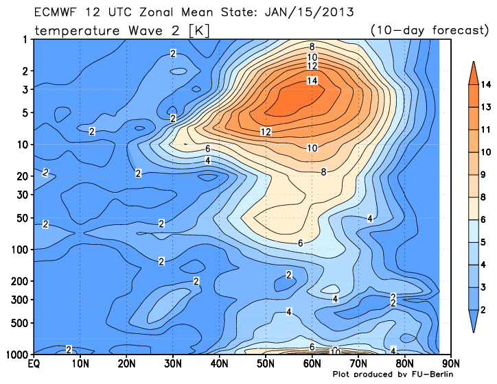
And now we take a look at Wave 2 of the temperature and geopotential height departments:

 The charts may look complicated, but in reality they are very easy to decipher. For the top image, we see Wave 2 of the temperature forecast for Day 10. When there are higher temperatures in this image, one tends to see warming occur in the areas the warmest anomalies are over. For example, the warmest temperature anomalies are over the 2mb-20mb regions, meaning that is where you would expect to find the most stratospheric warming. As for the geopotential height Wave 2 forecast on the bottom, when you find warmer colors, it signifies higher pressure which is just that: high pressure. And high pressure working against low pressure (polar vortex) can result in weakening of the polar vortex. So the fact that high pressure is appearing in the Day 10 forecast is good news as far as weakening the polar vortex goes.
 All those images were from the ECMWF model, and the above image here is from the GFS model. It is also showing the Third Warming, but at a slightly later timeframe (24 hours later than the ECMWF). The strongest warming appears to be forecasted over Canada and the Northern US. A quick glance at geopotential heights for the 10mb layer (same layer as the temperature image above) shows that this warming would strike right in the heart of the polar vortex at that level, possibly leading to a collapse of that particular vortice. From then on, it's anyones guess as to what happens.
Considering the North Atlantic Oscillation should be strongly negative during the timeframe of January 13 onward, and the Arctic Oscillation eventually going to trend strongly negative as well, it is inevitable that at least some of the nation will be greeted by some harsh cold weather. When the Madden Julian Oscillation (MJO) heads to Phase 8 in late January, we will have three indices working for harsh cold for the States. I see no reason to believe winter is over. A negative AO and negative NAO come together to incite much of the nation to be colder than normal. Considering this cold air will be pure Arctic air, if the cold air does flow south, you can bet it will be a very sharp cold outbreak, not a quick cold shot and then warmth again.
Andrew


Let's take a look now at past and present images of the 30 millibar layer:
 |
| 30mb Temperatures and Heights on December 29, 2012 |
 |
| 30mb Temperatures and Heights on January 4, 2013. |
The more likely route to take would probably be a piece of the polar vortex splitting into multiple daughter vortices, with one going into Canada and the other staying in Europe. The warm temperature anomalies would then push poleward and instigate high pressure formation in between the two vortices to keep the vortices apart. The split is the first crucial step to a complete collapse of a polar vortex collapse. Will there be another SSW? I'll explain the potential later on.


Now that we have a good prognosis on how the stratosphere is at the moment, let's see forecasted conditions for the stratosphere.


This is what I have been calling the Second Warming. When this SSW happens, we will see the split of the polar vortex, in what has been found as a three-step disintegration of the polar vortex: Displacement, Split and Collapse. We already had the displacement with the sudden stratospheric warming in late December, and this incoming warming event will lead to the Split. Now, I will show you increasing prospects for the Third Warming, what could become the final step in this three step process: the Collapse.


And now we take a look at Wave 2 of the temperature and geopotential height departments:


Considering the North Atlantic Oscillation should be strongly negative during the timeframe of January 13 onward, and the Arctic Oscillation eventually going to trend strongly negative as well, it is inevitable that at least some of the nation will be greeted by some harsh cold weather. When the Madden Julian Oscillation (MJO) heads to Phase 8 in late January, we will have three indices working for harsh cold for the States. I see no reason to believe winter is over. A negative AO and negative NAO come together to incite much of the nation to be colder than normal. Considering this cold air will be pure Arctic air, if the cold air does flow south, you can bet it will be a very sharp cold outbreak, not a quick cold shot and then warmth again.
Andrew
10 comments:
What about storm track, will there be snow in Ohio valley?
Another great post Andrew.
Latest ECMWF says the -NAO seems to be going. Do you think so, and if so what does that do to the forecast?
So everything Is on course, Andrew? A little variance on the GFS seems to rattle things a bit but doesn't deem to alter what's coming. Is my assumption correct?
Peter
One more thing, Chicago is one of many cities underperforming and snowless. Do you feel relatively good about a turn around? I know there's cold--you've been on that for a while but regarding precip, you stated you'd comment on that soon. Thanks Andrew. Fine job all around.
Thanks Andrew for giving us a great explanation of what we can expect. I know the Shenandoah Valley will get the cold, what about the chances of a storm coming up the valley? Appreciate all the hard work putting the blog together
The cold outbreak is fine and dandy and all, but here in Colorado, we are mostly concerned about snow, we need moisture like these doomsday paranoid schizophrenics need to get a life, and that's saying alot.
Lately, the storm track has been so far south that we don't even really see clouds.
It's getting a little worrisome, as we don't need any more dryness, the drought's already bad enough, we can't afford it getting worse, so is there any good news about any storms turning in our favor?
what happened to the "great lakes clipper" the storm just fall off the grid where did it go or is it still on track but you got sidetracked in all this cold coming
Andrew, I must say these strat warm posts are incredible. I have learned a ton!! That said, the ensembles have lost the blocking and I see NO severe cold. It just seems the strat warm as impressive as it is will not amount to anything in the lower 48. It just DOES NOT GET COLD HERE ANYMORE. We just have to get used to hearing how frigid it is everywhere else. If this strat warm were going to effect the lower 48 in any significant way, we would see it in the ensembles... Waiting on severe cold here is like waiting to win the lottery... But this does not take away from your posts, the are excellent. It just seems we will NOT get the result you thought.
Cold is good.
What about the snow though? Also where would it b?
Anonymous at 6:56: This does not deal with the snow- That is TBD.
Simon: The negative NAO will be tricky, and I will go into detail on that at 5:00 PM.
PK: Things are going according to plan. I think Chicago will end up well below normal yet again this winter, unfortunately. Details later on.
Anonymous from SV: I will discuss more on snow tomorrow or Wednesday.
Anonymous in CO: A deep negative PNA will set up a good stormy pattern for the Rockies beginning in a few days.
Anonymous at 12:29: It is still on course, the cold has sidetracked it.
Anonymous at 12:55: Wait and see- we will see the effects after Jan. 20.
Anonymous at 3:20: I will make a post on snow in coming days.
Post a Comment