
The overall weather pattern for the United States looks like a solid warm-up is on the way, and with it a more active storm pattern.
 We start with the forecast for the Arctic Oscillation, valid over the next several days. The black line shows the current forecast, with the other colored lines indicating past forecasts. We see that the forecast for the Arctic Oscillation is another dive to deep negative territory, followed by a tremendous spike into positive territory. If you'll notice, we have had a negative Arctic Oscillation for a while, which means high pressure is stationed over the Arctic. When the Arctic Oscillation (AO) is negative, cold air is more encouraged to hit the United States, and this effect has been shown greatly over the past few weeks. If you want something to blame for the chilly start to spring, this is your culprit. The spike to positive territory means we should see low pressure building back over the Arctic, allowing for warmer air to flow back into the nation.
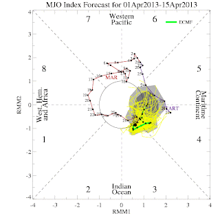 Another index we can look to for temperature guidance is the Madden-Julian Oscillation, or MJO. The MJO involves the location of convection along the equator in the Pacific Ocean. Each phase indicates a different location for this convection, and each phase affects the US differently. For example, when the MJO is in Phases 8-2 in the winter, we can expect cold weather. We see the index moving into Phases 4 and 5 in coming days, as shown above by the European model. These phases in the springtime tend to favor a slightly warm/slightly cool nation, switching back and forth depending on the strength of the phase. We see that the MJO is close to the circle at the center of the image, meaning it will be weak when it enters these phases. Nonetheless, I expect the incoming warm trend to be assisted at least slightly by the MJO. With the MJO in Phases 4 and 5, storms in the West can also become more common, which then forces high pressure formation in the East. This trait usually shows itself in the winter, but could also become present in early mid-spring.
 A third, more complicated index can explain what the models are seeing. Shown above is something called the Earth AAM Tendency chart. Without going too deep into this complicated index, the Earth AAM can help us predict incoming temperature patterns. It appears that when the Earth AAM (EAAM) is negative, colder weather becomes more prevalent. In the same sense, a positive EAAM favors warmer weather. Recently, we began seeing a spike in EAAM Tendency values not seen this year. The fact that the Earth AAM Tendency is strongly positive means the Earth AAM itself should also begin to rise to more positive values, helping along the warmer pattern that will be ushered in.
 The Climate Prediction Center is on board with this warm-up, predicting over a 60% chance of above normal temperatures across the central and eastern US. The higher the probability, the more likely a strong warm up will occur. With the pattern beginning to favor a stormy West US, it is only logical that we would see a warm and quiet East. This quiet will only last for so long- the storms in the West have to go somewhere. The storm systems beginning to progress east into this warmth then allows us to confront the potential of multiple severe weather events, the first of which is on the horizon and can be seen on the blog.
Andrew


Andrew
1 comment:
Thanks for the post Andrew, and this is obviously not good news, because we still will have cold air locked over Canada and northern North America from the very persistent snowpack, this warm-up will help to open up the Gulf of Mexico and establish the necessary NW-SE temperature gradient that fuels mid-latitude cyclones and helps to amplify severe wx outbreaks. Not to mention the fact that when you look at the 400 millibar temperatures, they have fallen again as of late and considering the fact that I anticipate an active hurricane landfall season (will have my post on weatheradvance later this week) similar to 1969, 1979, 1960, 2004, & 2010, and when you look at the tornado seasons of those active seasons (except 2010) you see that the tornado seasons were particularly active later in the season towards May & even June, and this is also consistent to our overall current pattern similar to the 1950s with a cold PDO, warm AMO combination, in which many of those tornado seasons were also back-loaded.
Post a Comment