

The Big Picture
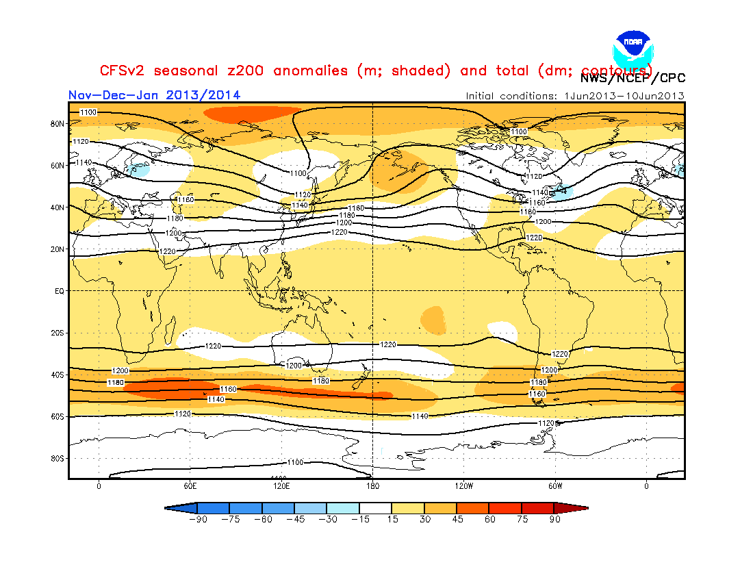
Many people are up in arms over the latest CFS model forecasts for this winter trending from a brutally cold US winter to a rather average, or even slightly above average winter in the temperature department. These are the times when people tend to show a different side- the side that tells a forecaster he/she was wrong about the CFS forecast when they posted how it was advertising a cold winter. People can get particularly nasty towards forecasters who don't deserve it. I posted about the CFS cold trend; luckily, all of you are polite folk who haven't thrown around vulgar comments like I've seen other forecasters get as a result of this sort of situation, when a model suddenly changes its forecasts. But I'm going off on a tangent now. The big picture here is that the CFS really has not changed its forecast as far as the atmospheric pattern goes. While temperature forecasts may have changed, it's pretty apparent that the CFS remains steadfast on a favorable mid/upper level atmospheric flow for the upcoming winter. You will see in the image above that I have five areas of interest numbered from 1 to 5. Each area of interest will be described below.
1. Active East Asian Jet Stream
You will see a tightening of the contour lines in eastern Asia on the image above, under the number 1. This symbolizes the jet stream is under stress, thus increasing its strength in that area. From looking solely at the image above, it would appear pressure anomalies are below normal in East Asia, meaning more storms in that region. If you have been with this blog for a while now, you may recall the times I have brought up a correlation between storms in East Asia and storms in the East US 6-10 days later. If the tightening of the jet stream in E. Asia is due to a stormier pattern in that area, it is entirely possible we see a stormier East US. Let the record show that the CFS has been adamant with this particular item for some time now: November-December-January 200mb forecast from June 2013
2. Ridging Pattern in Northern Pacific
It is well established that the Bering Sea is a favorite place for the origination of sudden stratospheric warmings (SSW's), a phenomenon that involves rapid warming in the stratosphere that then allows unusually cold air to reach the surface and lower latitudes just a couple of weeks later. Last winter, we saw a magnificent SSW originate from the Bering Sea, and other warmings attempt to take place in that same vicinity. With positive height anomalies stationed over the Bering Sea, intrusions of warm air by these positive height anomalies into the Arctic are more easily accomplished, thus increasing the likelihood of SSW events. Once again, this feature has been displayed on CFS forecasts for multiple months now, as the above link depicts. Additionally, bear in mind that these features were in the forecast when the CFS was projecting a very cold winter. In my opinion, it could very well be that the CFS is flopping around with its temperature forecast, as is customary of long range models, while the upper level atmospheric flow really tells the story (i.e. the pattern really is favorable for cold weather, even though temperature forecasts do not reflect it).
3. Ridging Pattern in Western North America
The image at the top of this post displays a widening of contour lines under the number 3. When you get the expansion of these lines, it is typically demonstrative of high pressure anomalies present in the area. The presence of high pressure anomalies in Western Nor. America is defined as a positive Pacific-North American index (PNA) pattern. In response to high pressure in the West US, low pressure (and thus cold air) is favored in the Central and East US. It is also known that a positive PNA results in winter storms taking a track favorable for the Midwest/Ohio Valley to receive snowfall. Yet again, the June CFS forecast identified the +PNA pattern for this winter, just as the current forecast shows.
4. Low Pressure in Eastern North America
This is kind of an extension of Number 3, in the sense of a low pressure response to positive height anomalies across the West US due to the positive PNA pattern. The CFS is picking up on those low pressure anomalies, though the model is reluctant to allow the anomalies to stretch into the United States. My theory on this is that, because the model is showing a forecast averaged out over 3 months, low pressure anomalies/cold weather DOES make it into the US due to the +PNA pattern. The reason why the model may be reluctant to do that on the image above is because we could see high pressure in the Bering Sea work against development of the +PNA pattern, thus preventing low pressure anomalies from reaching the US.
5. High-Latitude Blocking Pattern in Greenland
The image above shows an expansion of contour lines towards Greenland, an indicator that high pressure anomalies are favored in that area. Positive height anomalies in/near Greenland results in the negative phase of the North Atlantic Oscillation. The North Atlantic Oscillation (NAO) is a phenomenon that involves height anomalies across Greenland. In the negative NAO, high pressure is stationed over the land mass in a move that permits cold air and Nor'easter's to affect the Eastern US. On the other hand, a wintertime positive NAO results in a warmer United States with lower probabilities of big snowstorms for the nation as a whole. I brought about the theory that averaging out three months in a forecast may not project the real picture, and that theory also applies here. It applies here in the sense that the NAO may be very negative at times, but may also be less negative during some times. The tendency for a more negative NAO over a less negative/more positive NAO for this three month period in winter may then lead to pressure anomalies averaging out positive over Greenland (a sign of the negative NAO), thus showing an expansion of contour lines towards that region.
As the title of this post says, don't worry, be happy. Concerns over the increasingly-warmer CFS forecast for this winter are unwarranted on the basis that the mid/upper level air pattern has been steadfast throughout the last few months, including the time when the CFS was calling for a brutally cold US. The five points I discussed above have been steadfast in the last few months, and those same five points, when in place during the winter, do tend to set up a favorable pattern for cold and snow in the US area east of the Front Range.
Andrew
17 comments:
Good to hear Andrew! Would you say that despite the temperature forecasts the CFS, the mid/upper level air pattern is pretty much the same as the previous CFS run showing a brutally cold winter? Because if that's so, it still looks like the previous CFS was on point with it's temp forecast do to upper level patterns correct?
Thanks again!
The pattern the CFS is showing would be pretty good for the Chitown Metro, as it would warrant a lot of clippers. Maybe not blockbuster storms, but a lot of good nickel and dime storms that would really make this winter... you know... Wintry lol.
I think people might take you more seriously if you weren't always trying to find ways to forecast cold and snowy. Sometimes the forecast is for mild or warmer, if that's the case then so be it. I can't really take you and your cohorts seriously when all you do is try to find myriad ways of forecasting only what you really want and hope it will be.
Jessica:That is correct; the upper level flow has remained the same throughout the brutal cold forecast to the current forecast.
Interested Reader: While I do like cold and snow personally, the only way I show it on my blog is by telling others what patterns are good for winter weather lovers, and in posts like these, show why a recent event should not be discouraging. At the same time, I always show the forecast I am most confident in, regardless whether it be warm or cold for the winter. This is the first time I have made a quality analog set that actually has a good chance of verifying, so of course I'm going to use it and adjust my forecast accordingly because of how well the analog set has already done, and how I predict it will verify this winter. I assure you that this winter, my forecasts are not the result of any bias I may have- they are the result of hard research.
You know actually I find your forecast Andrew to be right on target, you always know weeks before it seems when a storm is coming & that in turn allows me to make plans that I would have been caught off guard had I not been reading your forecast religiously. All the TV stations here anyway, never seem to know what’s going to happen! That again, is why I count on Andrew’s weather forecast! I don’t like cold & snow, hate it! But knowing what is coming I can adjust my mind to accept it! I would love a winter like I think it was back in December 2010/2011 I think that was warm & mild? I know 2009, & at the beginning of 2010, was awful!
Anyway, Thank you Andrew for your hard work! Please continue giving us what you believe is going to happen with the weather, the good, bad, & the ugly! You may have some misses here & there, but, I’ve yet to notice them! And when/if that does happen, its ok, we are all only human! Energy is always changing!
bree
I appreciate your hardwork on this current forecast. But, I can't say I'm happy about it being that I live in the desert southwest. We need a good winter for once especially for the mountains more so than where I live. Lastly, in no way am I disappointed with you on the forecast. It is weather and whatever happens happens. Just was hoping for a little more snow, usually it always gets cold and snows no matter what. But, dustings don't do whole lot. Thanks.
With this information, what do you think the winter may be like for central New Jersey or in general the East Coast? Great forecast!
Anonymous at 3:21: This is just an informative post, not really a forecast. I'm afraid you'll have to either use my Preliminary winter forecast or wait for my official winter forecast on the 31st of this month.
Andrew:
Really enjoy reading your post. I know its not an easy thing to forecast 3-6 months out and really appreciate your work. Unfortunatley I am in the Oil business in the Northeast, and the winters have gone from brutal, to mild, to just normal. My money says this is going to be cold. I think there is a 3 year swing. Look that up. Every 3 years we have huge snow in the Northeast USA. Also look up patterns and trends. I have noticed 3 months of rain yields 3 months of droughts.
i enjoy ur forecasts and i expect a cold winter .
do you think that a la nina effect will bear any effect on that?
Euro monthlies just came out and looks oretty good in terms of blocking. Have you taken a look at them yet?
Is this a good sign for people in Indianapolis?
Anonymous at 8:20: I appreciate the thanks. That is an interesting pattern you've described; if I find some time in the next week or two, I might have to look that one up.
Anonymous at 10:54: We are expecting a Neutral ENSO, not a La Nina. However, that is only if cold water temps warm up in coming months; if not, we may have a La Nina set-up, which could help with cold air in some areas of the nation.
Anonymous at 4:55: I do not have access to the Euro monthlies, and have heard conflicting reports from those who have seen it. I wouldn't be surprised if it looks good for blocking; that's something I expect we will see quite a bit of this winter.
Anonymous at 5:02: This is just a general post, and does not apply to certain cities or locations.
I'm halpy your releasing your winter forecast at the end of the month! Always really interesting to read. But do you have any concerns that it may be a little too far out to release a winter forecast?
Andrew by this point you have a very popular weather blog. I think it would be good for you to set up an advertisement system on your blog so you could get funds from your blog. That way you could get some cash to help pay off the WeatherBell sub :)
Anonymous at 5:21: Due to recent success of my analog set for this winter, I am confident in issuing the forecast this early. Updates will be made as necessary, though I do not anticipate more than one update during September (depending on if an update is even needed).
Anonymous at 11:13: I've been in the process of trying to determine if my blog is able to legally advertise for a few months now, as some images I have posted over the years may need to be removed.
Post a Comment