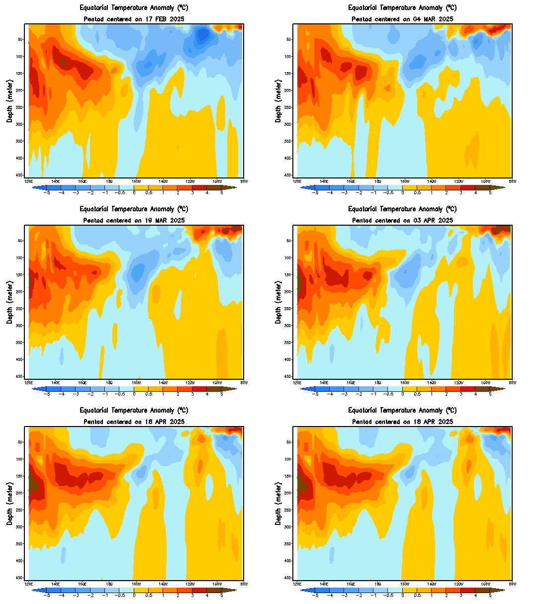
The warm water anomalies in the central Pacific look to be pushing towards the surface, possibly inducing the expected weak El Nino for this fall and winter.
The animation above shows water temperature anomalies along the Equator, on a depth-longitude graph. We can see the extremely above-normal waters pushing into the surface earlier this summer, a byproduct of the Kelvin Wave that traversed the Pacific during this past spring. After the warm waters dissipated, we saw a swath of below-normal water temperatures take over. This put us back to the same neutral-ENSO / Cool-Neutral ENSO situation we've been in for the past couple of years. Fast-forward to the present, and we see a new situation developing.
Warm water anomalies have been steadily building underwater around the Central Pacific region, between about 100 to 200 meters below the surface. These waters have been organizing themselves in recent days and weeks, and the eastern-most portion of these positive anomalies has begun shifting towards the surface, and towards the east. It is currently expected that these warm waters will push east and eat away at the below-normal water temperatures. If the warmth can sustain itself and hit the surface, this should be our weak El Nino, possibly more towards a moderate El Nino at best.
In order to actually see an El Nino develop, however, we'll need to see the atmosphere respond, which isn't happening just yet. Shown above are two panels; one shows the mean surface wind currents across the Equatorial Pacific, while the bottom one displays anomalous wind currents. In order for the atmosphere to indicate an El Nino is present, we would have to see winds going from west to east, as part of the reversed Walker Circulation, which is displayed below in the form of the regular circulation.
In the Walker Circulation, surface winds go east-to-west, where the air rises due to convection near Australia. Upper-level winds then push west-to-east, before sinking near the South America coastline, completing the circulation. This is commonly seen in a La Nina event. The El Nino reverses the Walker Circulation, where surface winds push west-to-east, allowing convection to develop along the coast of South America. Upper level winds are carried westward, before sinking near Australia.
If we look back at the surface wind current image above, we can see the winds along the Equator pushing predominantly to the west, indicating that the atmosphere is not favorable for an El Nino. We have yet to see if this will change in coming months, and if it may allow for an El Nino to actually establish itself.
Andrew
 |
| CPC Refresh the page if animation stops looping |
Warm water anomalies have been steadily building underwater around the Central Pacific region, between about 100 to 200 meters below the surface. These waters have been organizing themselves in recent days and weeks, and the eastern-most portion of these positive anomalies has begun shifting towards the surface, and towards the east. It is currently expected that these warm waters will push east and eat away at the below-normal water temperatures. If the warmth can sustain itself and hit the surface, this should be our weak El Nino, possibly more towards a moderate El Nino at best.
 |
| NOAA |
 |
| BOM Switch wind direction and warm/cool anomalies' places to observe reversed (El Nino) Walker Circulation. |
If we look back at the surface wind current image above, we can see the winds along the Equator pushing predominantly to the west, indicating that the atmosphere is not favorable for an El Nino. We have yet to see if this will change in coming months, and if it may allow for an El Nino to actually establish itself.
Andrew

1 comment:
I have never lost faith that there would not be a El-Nino!.....I have known for quite sometime that it would not be the much hyped "Super El-Nino. We here in NC and all up and down the east coast need to...Look to and watch the pool of warm water in the Northwest and pay attention to the NAO....
Post a Comment