Thursday, May 16, 2013

Significant Severe Weather Outbreak Hits Plains This Weekend

A significant severe weather outbreak may hit the Plains and Midwest this weekend. Although the title does not indicate it, this event is still rather uncertain and is not set in stone.

Synoptic set-up begins with storm system digging through Northern Plains and pushing down towards the central Plains. Negative tilt will evolve with this system, and high pressure will blossom through the Midwest into southern Canada. As a result of this negative tilt digging southeast, instability and moisture will flow freely throughout the Plains and Midwest, resulting in significant severe weather potential. Saturday severe weather potential looks to be a stormy day for the Northern Plains, with the potential for all modes of severe weather. Sunday appears to be the most significant day of this trio, as the storm goes into a full-on negative tilt and gets the severe weather going. There is potential for a severe weather outbreak on Sunday evening, as extreme instability and a rather favorable environment for tornadoes takes over the area outlined in turquoise. We'll get a bit more in-depth on Sunday later on in this post. Monday looks to be an interesting day still, although at this point the storm system as become a closed low and the negative tilt has dissipated. We should still see a severe weather event for those in the dark blue, although the depth of this event is to be determined. When gathering all the facts for all three days, and after examining several modes of forecasting tools, I anticipate that a (potentially significant) severe weather outbreak will get going this weekend.

June 8, 1993

June 11, 2004
I went through a series of analog dates that were spit out by the CIPS system for Sunday evening. Precipitation is shown on the top left, 500mb vorticity values on the bottom left, and 300mb wind speeds on the bottom right. The only one we care about in both of these images is the bottom right image, which shows that date's 300 millibar wind speeds and pressure contours. The reason I want to focus on this is because we will be able to determine which analog dates are most similar to the upcoming severe weather event by looking for the negative tilt, where 300mb winds are to the southeast of the storm's center, and by looking for the massive ridge extending from the Midwest into Canada. We see both of these analog dates have these features we're looking for, though with varying strength in storm system and wind speed. Now that we have our two dates that best match up with this upcoming event, let's look at storm reports for both of these days.

June 11, 2004 Observed Storm Reports

June 8, 1993 Observed Storm Reports
We see both images had fairly solid severe weather events on their respective days, with June 8 1993 having the more active day. The fact that the 1993 date is more significant does not surprise me- the storm system is stronger in 1993 than 2004. It's also the reason why I believe that this event will turn out like what happened in June 8, 1993. The storm system that will be arriving this weekend will also be pretty strong, possibly a good comparison to June 8, 1993.

When looking at the top 15 analog dates that the CIPS system is putting out for this event, you can see why I'm concerned for this weekend. The top 9 analogs all had rather large severe weather outbreaks across the Plains and into the Midwest; not unlike what we could see this weekend. I feel that we will see this severe weather event centered in the eastern Plains and not so much in the Northern Plains as the June 8 1993 analog suggests. However, we're still a long ways out from this multi-day event, and multiple small-scale factors need to be determined before we can figure out who could be in the target zone for this multi-day event.

Andrew

Tuesday, May 14, 2013

Invest 90E - Tropical Cyclone Development Possible

Tropical invest 90 has formed in the Eastern Pacific Ocean. The National Hurricane Center has gauged this invest to have a 30 percent chance of tropical cyclone development in the next 48 hours.

Discussion... Tropical convection has formed to the south of Mexico and has concentrated itself into an area of low pressure. This low pressure area has no defined circulation or extreme convection, indicating tropical cyclone development will likely occur in the 48 to 72 hour period, if development occurs at all.

Model guidance predicts this system to move generally to the northwest over the next few days, while intensity forecasts project this cyclone to develop into a cyclone generally between the Hour 36 and Hour 72 mark. This puts us in the latter half of the workweek to see the first real chance of development.

Projections

Chance of tropical cyclone development: Medium-High
Chance of hurricane development: Low
Chance of major hurricane development: Very Low
Chance of landfall: Very Low

Andrew

Multi-Day Severe Weather Event This Weekend

A multi-day severe weather event may be evolving for the upcoming weekend.

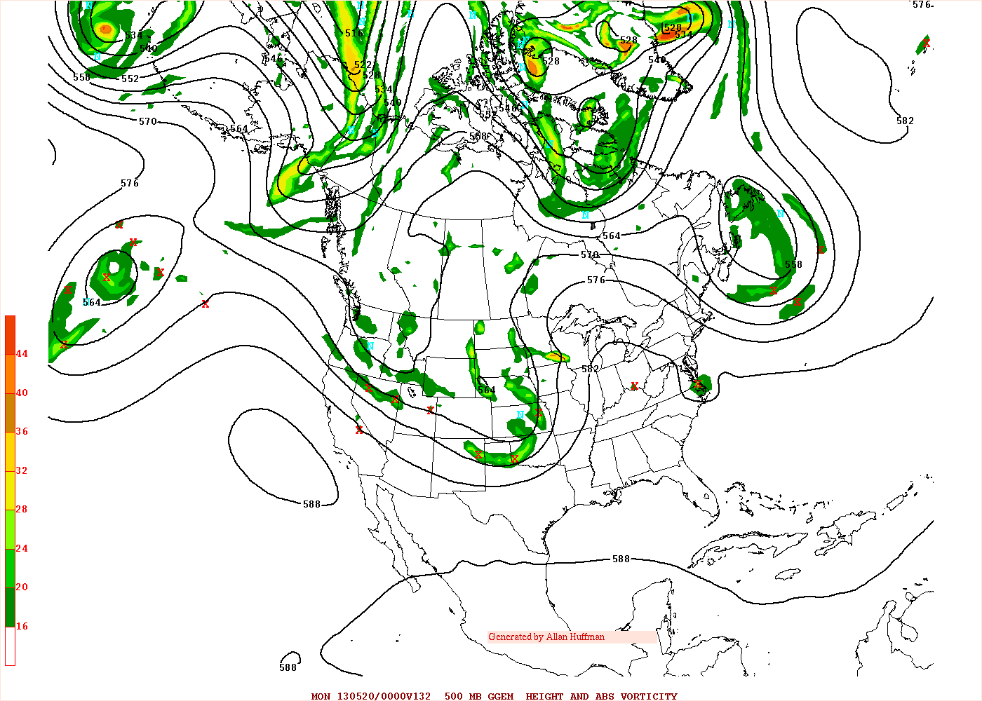
Unusual model confidence leads the Weather Prediction Center to turn to the GGEM model for this afternoon's forecast preference. Due to the large difference between the ECMWF and GFS models, the idea of turning to the Canadian model looks like the safest bet at this time.

Storm system will dig into the Plains to round out the workweek, with highest vorticity values tilting to the southeast to declare the development of a negative tilt in the storm system. Increased 'digging' from this negative tilt will enhance building of the high pressure ridge over the Midwest, Great Lakes and Ohio Valley, as evidenced by the large arcing formation over the aforementioned regions. It is at this time I anticipate we will see the most prevalent severe weather. This would set the stage for a Sunday evening severe weather event. Don't get me wrong here, Saturday looks to be active as well, but what makes Sunday more worthy of discussion is how quickly the negative tilt will transition into a closed low set-up that will essentially decimate severe weather chances for those east of the Ohio Valley. As the negative tilted storm system continues digging towards the Southwest, it will eventually reach a point where it can no longer push southeast and must then swing its highest vorticity values north in a circular formation. From there, the closed low develops, and severe weather basically ends. Until then (Monday-Tuesday), however, severe weather will remain in play for the Plains and Midwest.

A few factors will play into the development of this event. We will start off seeing massive upper-level divergence of the jet stream, which will allow instability to build with relative ease. A caveat to this unstable environment will be rather consistent model projections of a stubborn capping mechanism above the surface to prevent thunderstorms from forming. The more prevalent issue will be the wide expanse and amount of moisture that will be spilled over the United States from the Gulf of Mexico. As the image above shows, forecasts predict that precipitable water values (a measure of moisture in the air) could easily surpass 1 inch in many portions of the nation. That means that if you were to compress a column of air in any given space and extract the water from that air, it would equal over an inch of solid water. In summary, amounts over 1 inch tend to make for a humid day- amounts over 1.5 inches can be just downright nasty as far as how humid it gets.

I've remade my forecast map to respect my thoughts in cooperation with the Storm Prediction Center's ideas on how this will go down. I anticipate Saturday's severe threat to target the Plains, while Sunday will be reserved for the Midwest.

Andrew

Monday, May 13, 2013

Weekend Severe Weather Threat Could Be Significant

It's looking more and more like this weekend could hold a potentially significant severe weather event for portions of the country.

Situation begins unfolding with a storm system digging into the central Plains Saturday afternoon. 500mb vorticity values from the latest GFS model indicate that the event should begin in Nebraska, Kansas and possibly into Oklahoma. Current indications are that this event will be the beginning of a multi-day severe weather event. This Saturday portion appears to be aligned with a damaging wind and hail threat, with the tornado threat sitting in the background. Storm system will be pushing into the Plains getting ready to go towards a negative tilt, which should happen on Sunday.

Instability parameters for Saturday are impressive across the Plains, with as much as 4000 j/kg of capped instability spread across the western portions of Kansas and Nebraska. Capping inversion is certainly a concern with this event, especially on Saturday, but as the storm begins to get a negative tilt we should see instability increase and the risk of nasty storms increase as well.

Sunday becomes a much more significant day in my opinion, as the storm system begins to dig hard and achieve a negative tilt in the process. Significant vorticity lobes are draped across the Plains and Upper Midwest along the sharp height gradient between storm and ridge. This gradient appears to be centered in the Midwest, and it is here where we may see the strongest storms of the day hit. Cities like the Quad Cities in Iowa, Chicago and Rockford in Illinois, and Milwaukee and Madison in Wisconsin may see some nasty weather on Sunday. Instability parameters show over 5000 j/kg of instability overnight Saturday, decreasing into the mid-3000's by evening on Sunday.

When the trough begins to tilt negatively, it looks like the storm formation style will shift towards a more linear system. My gut tells me we'll see either a squall line or at least some form of linear convective system that moves through the Midwest. I find it hard to believe the environment presented by the GFS above supports an individual cell-type storm over a linear storm system.

Another thing to be watchful of is the massive amount of moisture that will be flooding the Plains and everyone on eastward. With the quantity of moisture that will be present in the United States as the severe weather event blows through, I would bet on at least a marginal flooding risk evolving across portions of the nation over the weekend and into the beginning of next workweek. Now, we're a while out from this event, so I can't get into the depth or expanse of this flooding potential, but when you have this amount of moisture just waiting to be converted to rain, it's easy to find a little flooding potential that could escalate quickly.

As of the current time, my map for this multi-day event is below.

Andrew

Saturday, May 11, 2013

Weather Overview for May 11, 2013


Midwest: Two cold fronts are pushing through the region at this hour, with the northernmost frontal boundary being forced south by a vorticity center that is bottoming out into the Great Lakes. Progression of these cold fronts will lead to a chilly weekend before a gradual warm-up builds into the mid-week. No severe weather expected.

Northeast/Mid-Atlantic: Cold front progressing east will interact with a region of heightened moisture in the Mid-Atlantic and initiate showers and thunderstorms. Current Storm Prediction Center outlook highlights this area for a Slight Risk of severe weather. Cooler temperatures expected as cold fronts are moved east in coming days. Severe weather is possible.

Southeast/Gulf Coast: Low pressure system that initiated strong thunderstorms in Texas last night has shifted into Mexico as the complex of active weather skirts the Gulf Coast, mainly confined over the Gulf of Mexico waters. Isolated strong weather risk along the coastline before the complex of showers and thunderstorms makes landfall in Florida. Severe weather is possible during that time.

Pacific Northwest: Disturbance is being pushed north into Canada as a result of high pressure development in the Western United States. Despite the movement of this disturbance away from the region, precipitation remains possible. Most likely scenario is a cloudy day with precipitation entering the region this evening as the back-end of this disturbance is far enough south to interact with the Pacific Northwest. No severe weather expected.

Andrew