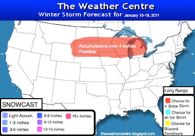
There is potential for a snowstorm in the Upper Midwest and Great Lakes going into January 15-19 as a low pressure system is forecasted to be right up against the Gary, Indiana area. This is an interesting scenario, and here's why:
NWS Quad Cities Area Forecast Discussion:
The Quad Cities NWS office is mentioning how the models are moving south with this system, which would indeed bring snow to cities like Chicago that have just been introduced to winter. We have noticed this southward shift in the ensembles as well.
The first image is what the Hydrometeorological Prediction Center, or the HPC is saying right now. The 4 inches part is at max right now, but of course subject to major changes.
Here's what may happen if the models continue shifting south:
Yes, we may see some snow move south as well.
We will continue to closely monitor the ensembles, as it is getting interesting seeing as this event is a mere 3-4 days away.
NWS Quad Cities Area Forecast Discussion:
.LONG TERM...SUNDAY THROUGH FRIDAY...THE RAIN/SNOW EVENT MONDAY INTO TUESDAY CONTINUES AS THE PRIMARYFORECAST ISSUE WITH ASSESSING SNOW IMPACTS ON TEMPERATURES.
OVERALL...INITIALIZATION AND VERIFICATION GOOD WITH EXISTING SNOWCOVER RESULTING IN COLDER TEMPERATURES AND NW ENERGY SLIDING FURTHERSW THE NEXT 24 HOURS AS OUTLINED IN LAST NIGHT/S DISCUSSION. RUNS
THE PAST 24 HOURS ALL ARE TRENDING FURTHER SOUTH WITH MONDAY SYSTEM
AS WELL WITH INITIALIZATION SUGGESTING THIS TREND MAY CONTINUE FOR AT
LEAST ANOTHER 12 PLUS HOURS.THE PAST 24 HOURS ALL ARE TRENDING FURTHER SOUTH WITH MONDAY SYSTEMAS WELL WITH INITIALIZATION SUGGESTING THIS TREND MAY CONTINUE FOR ATLEAST ANOTHER 12 PLUS HOURS. IF SO...THIS WOULD LIMIT AMOUNTS WITHBEST FORCING TO OUR SE. VERIFICATION OF LOW LEVEL THERMAL FIELDSSUGGEST HIGHEST WEIGHT TO 80KM NAM-WRF AND HI-RES ECMWF INTO DAY 3AND THEN MORE HI-RES ECMWF DAY 4 ONWARD. THE INCREASING SPEED OFMONDAY SYSTEM SUPPORTS ALSO LOWER AMOUNTS OF PRECIPITATION.
The Quad Cities NWS office is mentioning how the models are moving south with this system, which would indeed bring snow to cities like Chicago that have just been introduced to winter. We have noticed this southward shift in the ensembles as well.
The first image is what the Hydrometeorological Prediction Center, or the HPC is saying right now. The 4 inches part is at max right now, but of course subject to major changes.
Here's what may happen if the models continue shifting south:
Yes, we may see some snow move south as well.
We will continue to closely monitor the ensembles, as it is getting interesting seeing as this event is a mere 3-4 days away.


12 comments:
What track so YOU think is more likely?
Could it come to virginia?
OHIO WILL MISS OUT ON YET ANOTHER STORM.WAIT TILL THIS FEB.,OHIO WILL BE IN THE LINE FOR SOME MAJOR STORMS AS WELL AS THE EAST COAST AND MID-ATLANTIC STATES.I HAVE A FEELING.
TWENTY FOUR INCHES OF SNOW IN LAKE COUNTY OHIO.THE GOOD OLD SNOWBELT.
Aran: Probably the southern snow based on the Quad Cities discussion.
scoopy: Probably not.
Hi Andrew, hopefully you've been doing good. Does this storm look like the one we just got, if the storm track goes further south? Thanks.
LJ: No- that storm was a clipper with many special cases.
Other places in Ohio Valley need some snow. Chicago is gonna get hit now time after time. :(
I am ok with that.I live 60 miles southeast of Chicago.We are supposed to have thunderstorms at night and at day.
This goes with the post above: on Jan.22 and on Jan.23.
Aran: That, in my opinion, is too far out to forecast for.
I think so too.
Post a Comment