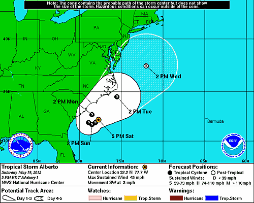
Tropical Storm Alberto is projected to make a u-turn and head northeast along the East Coast, posing threats to both Carolinas over the next few days before heading towards New England. Right now, I would guess, based on historical tracks, that this storm will likely miss the New England area and head towards the far north Atlantic areas. However, the Carolinas remain in the potential target zone and will have to be monitored.
Probabilities for tropical storm winds are mainly the highest out offshore the Carolinas, but the NHC has designated South Carolina with a 30% - 40% chance of tropical storm winds.


7 comments:
Sorry I haven't been able to post today. Now on to Alberto. HWRF to me is TOO strong and TOO far east. Alberto will make a landfall on the Outerbanks NC. NHC is also too far east. Coastal areas south of NYC will likely be impacted by rain bands/ energy from this system. Models do not habe a very good handle on this system. SVR wx possible for Easterners next week. More info in 2nd post./
Plains pounding. SPC's 30% risk well needed. Also a tornado watch not sever tstm watch281, should have been used. My friend Anonymous from Kansas, some of those storms were very strong. I hope you are okay. The Plains states/ Midwest may have a large # of svr events till the end of the month. East Coast included. /
Available to discuss weather if anyone is interested. Till 10 eastern, 9 central./
With the GFDL as far west as it is, I think the NHC will have to push the storm track WEST. This means that from South Carolina to NYC, you are in the potentila danger zone. Please monitor all future weather forecasts if you live in this zone. If this does end up being an East Coast hugger, i will put out as many updates and reports I can. Andrew, will certainly cover this one./
I will gladly take an East Coast hit. My boring life will be exciting for a while. Thought I saw something in the long range. ..................../
Alberto has weakened, and gthe NHC pushed the track EAST. Now I remember why to throw the GFDL away in this case. With hurricane Irene it was showing Irene slamming CENTRAL FLORIDA, while everything else said Outerbanks NC. GFDL has a past history of being too far west with systems./
Andrew, your area on north is in a slight risk for svr tstms. Enjoy and stay safe!!!!!!!!!/
Post a Comment