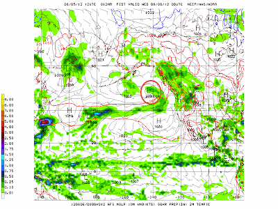
The GFS model is severely underestimating the strength of the storm system currently offshore that looks to either contribute or make up the strength of the system that will produce outbreaks of severe weather across the Northern Plains. Below shows the northern Pacific scene, valid at 7:00 PM CDT this evening.
The system we are watching I have circled in red. The 12z GFS clocks it at 999 millibars. Now, look below at the latest analysis from the Ocean Prediction Center, valid at 1:00 PM CDT this afternoon.
Here, the analysis of the system is at 995 millibars- 4 millibars lower than what the GFS is proposing. What this indicates is that the GFS appears to be underestimating the scope of the event.
Here is what will happen tomorrow.
-There will be no morning post.
-Around 1:30 PM CDT, I will be issuing a post concerning this multi-day severe weather event. When I issue this post, I will accompany it with a discussion that will take into account verification, much like I have shown above, in order to enhance my forecast.
Andrew


4 comments:
ECMWF looks better. I am using that.
El Nino is making its mark in the tropics!!!!!!!!!!!
Hey Andrew
I just looked on twisterdata, the system looks extremely powerful. They show a dynamic-pattern low system with 988mb center. It looks like the cold front is tightly veered and system has many short waves. The system may not be as strong on Saturday but will quickly strengthen overnight and become more dynamic Sunday. Problem however is coverage with GFS instability. The CAPE is mostly shown in the central and southern plains reaching 4500 j/kg. Lifted indices there too reach -12 or -13. The threatened areas have short-lived, barely, or no CAPE as well as little LIs. The CIN will be high with breaks here and there. The magic hodograph is hard to find, but Nebraska on Sunday( I believe, maybe), can have storms as early as 6am due to enough CAPE, buoyancy, strong jet, and a break in CIN nearby. The southern extent could be severe too due to instability available as shown but if the northern extent is as unstable enough as discussed to possibly handle such shear, the capping and dryline can help keep storms seperated and isolated from convergence. Take a look on GFS on twisterdata, I think you'll find it interesting. Take care!
Anonymous #3: I checked this morning's GFS, and whie Saturday looks fairly unsupportive, Sunday does look to have 5500+ j/kg of CAPE in eastern ND.
Post a Comment