
A multi-day severe weather event may be evolving for the upcoming weekend.
 Unusual model confidence leads the Weather Prediction Center to turn to the GGEM model for this afternoon's forecast preference. Due to the large difference between the ECMWF and GFS models, the idea of turning to the Canadian model looks like the safest bet at this time.
Storm system will dig into the Plains to round out the workweek, with highest vorticity values tilting to the southeast to declare the development of a negative tilt in the storm system. Increased 'digging' from this negative tilt will enhance building of the high pressure ridge over the Midwest, Great Lakes and Ohio Valley, as evidenced by the large arcing formation over the aforementioned regions. It is at this time I anticipate we will see the most prevalent severe weather. This would set the stage for a Sunday evening severe weather event. Don't get me wrong here, Saturday looks to be active as well, but what makes Sunday more worthy of discussion is how quickly the negative tilt will transition into a closed low set-up that will essentially decimate severe weather chances for those east of the Ohio Valley. As the negative tilted storm system continues digging towards the Southwest, it will eventually reach a point where it can no longer push southeast and must then swing its highest vorticity values north in a circular formation. From there, the closed low develops, and severe weather basically ends. Until then (Monday-Tuesday), however, severe weather will remain in play for the Plains and Midwest.
 A few factors will play into the development of this event. We will start off seeing massive upper-level divergence of the jet stream, which will allow instability to build with relative ease. A caveat to this unstable environment will be rather consistent model projections of a stubborn capping mechanism above the surface to prevent thunderstorms from forming. The more prevalent issue will be the wide expanse and amount of moisture that will be spilled over the United States from the Gulf of Mexico. As the image above shows, forecasts predict that precipitable water values (a measure of moisture in the air) could easily surpass 1 inch in many portions of the nation. That means that if you were to compress a column of air in any given space and extract the water from that air, it would equal over an inch of solid water. In summary, amounts over 1 inch tend to make for a humid day- amounts over 1.5 inches can be just downright nasty as far as how humid it gets.
 I've remade my forecast map to respect my thoughts in cooperation with the Storm Prediction Center's ideas on how this will go down. I anticipate Saturday's severe threat to target the Plains, while Sunday will be reserved for the Midwest.
Andrew
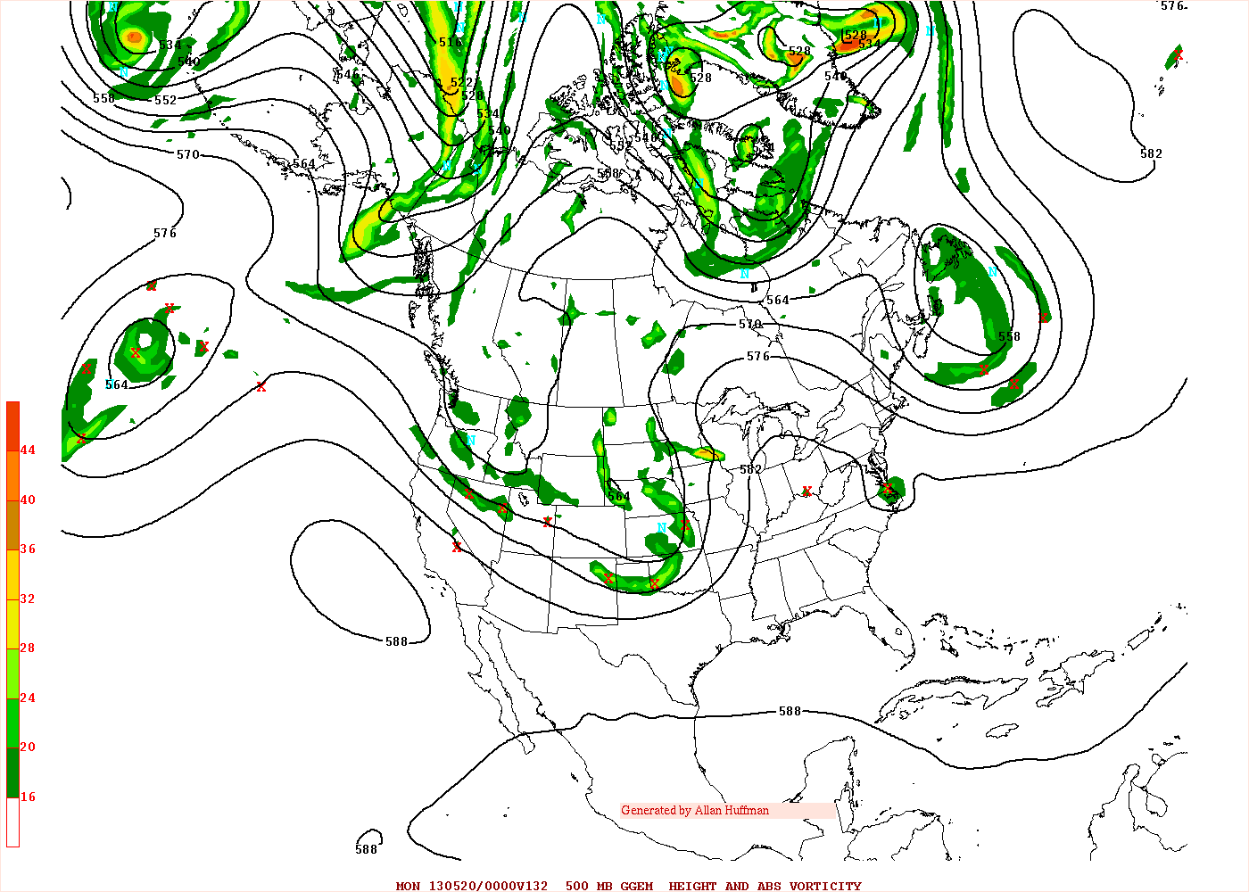
Storm system will dig into the Plains to round out the workweek, with highest vorticity values tilting to the southeast to declare the development of a negative tilt in the storm system. Increased 'digging' from this negative tilt will enhance building of the high pressure ridge over the Midwest, Great Lakes and Ohio Valley, as evidenced by the large arcing formation over the aforementioned regions. It is at this time I anticipate we will see the most prevalent severe weather. This would set the stage for a Sunday evening severe weather event. Don't get me wrong here, Saturday looks to be active as well, but what makes Sunday more worthy of discussion is how quickly the negative tilt will transition into a closed low set-up that will essentially decimate severe weather chances for those east of the Ohio Valley. As the negative tilted storm system continues digging towards the Southwest, it will eventually reach a point where it can no longer push southeast and must then swing its highest vorticity values north in a circular formation. From there, the closed low develops, and severe weather basically ends. Until then (Monday-Tuesday), however, severe weather will remain in play for the Plains and Midwest.


Andrew
3 comments:
I notice that the system seems to be moving ENE or NE as it travels through the country. This leads me to a question I have had trouble answering. Since it's moving NE/ENE, could southern VA get any of this system. (Severe weather wise) Thanks, Justin
This is just my prediction, but by the time the system reaches VA, it would have probably weakened. And the very few times I've seen severe storms in VA, there would always be that same limiting factor, which is weak instability. So, in my opinion, I don't expect a widespread severe event in VA. But, I might be convinced otherwise...
This is what I would like to know..due to the 4 X flares (solar flares) we have gotten within the last 48 hours, if memory serves me correctly, that when they hit our atmosphere makes our weather (In Iowa) hot! Usually with flares we miss the rain, But, I also know it at times cause nasty weather disturbances, (Ie...Earthquakes) in other area. Am I right about this? Solar Flares Being weather related? That is what I read.
Thank you so much!
bree
Post a Comment