
It does appear likely that a stratospheric warming event is in the works for the next week or so.
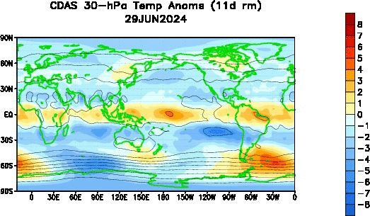 An animation of 30 millibar temperature anomalies high up in the stratosphere suggest above normal anomalies in eastern Asia, combined with a shifting body of warmth to the east from Europe will provide a base for what is expected to be a sudden stratospheric warming event. As both masses of warmth in northern Asia and southeast Asia intensify, it is expected that they will combine, and possibly push northeast into the Bering Sea to provide a base for this SSW.
 Mountain torque (MT) values around the 40N parallel are beginning to spike in coordination with this warmth in the upper stratosphere. Without getting too technical, it has been seen that above normal mountain torque anomalies come around when a sudden stratospheric warming event is immenint. I circled the spike in anomalies in black on the top panel to better highlight it. Taking a look back at the animation at the top of the post, we see this warming event is beginning around the 40N parallel, so it is no wonder we are seeing MT values on the rise in the same parallel region.
 The ECMWF model projects this event to reach its peak in about five days, when the maximum strength of the Wave 2 event occurs.

Now, there are two main types of stratospheric events that disturb or split the polar vortex. There is a Wave-1 response, which involves the polar vortex becoming elongated and/or weakened, however a split does not occur. This can result in displacement of the vortex out of the Arctic, but that prospect is not as likely as it is in a Wave-2 scenario. A Wave-2 stratospheric response involves the polar vortex being split into two main vortices, as the image from NASA shows above. While the temperature images show the Wave-1 and Wave-2 (top and bottom rows, respectfully) responses occur over Greenland and Eurasia, especially with the two split vortices where one vortex goes over Greenland and one goes into Eurasia, the split can lead the vortices into any land mass, not just those two regions.
We can deduce a few things from that ECMWF forecast image. For one, it appears that the event will be enhanced mainly over the upper stratosphere, and with an unfavorable Quasi-Biennial Oscillation, I doubt the polar vortex will split from this anticipated SSW alone. Second, it looks like the event is projected to occur at the 60N parallel, which is located in Canada and northern Asia. This, if it were to come true, would indicate the sudden stratospheric warming event would have shifted north and impacted the upper latitudes. I don't see the warming event protruding into the 90N parallel, which is nearly the highest possible latitude parallel in the northern hemisphere. This means that the SSW shouldn't slice and dice the polar vortex, which is what we're expecting (not the polar vortex split, but a lack thereof).
 As for what the future may hold for the stratosphere. 100 millibar eddy heat flux values have risen to normal levels after a nearly record-setting below normal stint in late November. Whether the rising heat flux continues remains in question, but such a trend would bode very well for the stratosphere, particularly later on in winter when the Quasi-Biennial Oscillation becomes more favorable for sudden stratospheric warmings.
Andrew


Now, there are two main types of stratospheric events that disturb or split the polar vortex. There is a Wave-1 response, which involves the polar vortex becoming elongated and/or weakened, however a split does not occur. This can result in displacement of the vortex out of the Arctic, but that prospect is not as likely as it is in a Wave-2 scenario. A Wave-2 stratospheric response involves the polar vortex being split into two main vortices, as the image from NASA shows above. While the temperature images show the Wave-1 and Wave-2 (top and bottom rows, respectfully) responses occur over Greenland and Eurasia, especially with the two split vortices where one vortex goes over Greenland and one goes into Eurasia, the split can lead the vortices into any land mass, not just those two regions.
We can deduce a few things from that ECMWF forecast image. For one, it appears that the event will be enhanced mainly over the upper stratosphere, and with an unfavorable Quasi-Biennial Oscillation, I doubt the polar vortex will split from this anticipated SSW alone. Second, it looks like the event is projected to occur at the 60N parallel, which is located in Canada and northern Asia. This, if it were to come true, would indicate the sudden stratospheric warming event would have shifted north and impacted the upper latitudes. I don't see the warming event protruding into the 90N parallel, which is nearly the highest possible latitude parallel in the northern hemisphere. This means that the SSW shouldn't slice and dice the polar vortex, which is what we're expecting (not the polar vortex split, but a lack thereof).

Andrew
2 comments:
So what are the results :D?
Too much details for us lol
Is it going to be a cold snowy winter or what?
For us laypersons, would you consider this to be a good analogy Andrew? "During an ongoing stratospheric warming event, the polar vortex splits in two, allowing polar air to spill out from the Arctic, as if a refrigerator door were suddenly opened.....it tilts the odds in favor of the development of winter storms "
Post a Comment