This is a discussion of the El Nino-Southern Oscillation for May 2013.
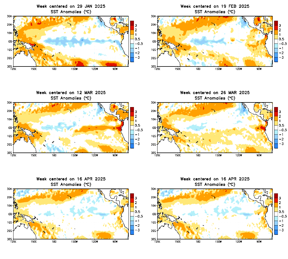
This animation of sea surface temperature anomalies from early February through late April shows conditions of water temperatures from the western Pacific to the eastern Pacific. Beginning in February and lasting through mid-March, we saw a weak strand of below-normal sea surface temperatures stretching on a nearly straight west-east line from the northwest South American coastline. This strand of slightly cooler than normal temperature anomalies dissipated by late March, bringing an end to whatever slight La Nina (colder than normal sea surface temperatures) may have otherwise developed. Beginning in the closing days of March, we began to see a warming trend across the same region of the eastern Pacific Ocean. However, because the waters were not sustained and not warm enough, an El Nino (warmer than normal sea surface temperatures) event did not develop. Since the beginning of April, ENSO-Neutral conditions have prevailed, with no defined El Nino or La Nina present at this time.
Image above depicts the current situation that is ongoing across the world's oceans with several different weather parameters. We begin with the top image, showing unfiltered VP200 anomalies. In a nutshell, a higher anomaly of this indicator tells one that tropical convection is enhanced in the area. A glance at our second indicator, labeled MJO, shows us that this tropical convection idea is true. A large swath of positive anomalies is outlined on the MJO indicator across the Indian Ocean and east towards the Philippines. The positive anomaly placed in those regions means that the Madden-Julian Oscillation is in Phases 1-2. When the MJO is in Phases 1-2, effects on the United States' weather include above normal precipitation in the central and east US, as well as below normal temperatures in the same regions. The expectation is for this MJO wave to strengthen and push east across the Pacific Ocean to progress the Madden-Julian Oscillation through its middle phases 3-5. These phases provoke slightly warmer and generally drier weather. As the MJO wave moves east, a Kelvin Wave already forming in the waters northwest of Australia should also push east. In the third image on the bottom, we see a highlighted blue oval, suggesting the presence of a Kelvin wave that will most likely move east with the MJO progression. As they both push east, the Kelvin wave should act to bolster attempts at producing an El Nino, as the Kelvin wave is known to enhance convection and boost warmer waters over the eastern Equatorial Pacific.
Summary
The ENSO state at the present time is: NEUTRAL
The presence of a Kelvin wave is: CONFIRMED
Likelihood of a changing ENSO state within 3 months: POSSIBLE
Andrew
This animation of sea surface temperature anomalies from early February through late April shows conditions of water temperatures from the western Pacific to the eastern Pacific. Beginning in February and lasting through mid-March, we saw a weak strand of below-normal sea surface temperatures stretching on a nearly straight west-east line from the northwest South American coastline. This strand of slightly cooler than normal temperature anomalies dissipated by late March, bringing an end to whatever slight La Nina (colder than normal sea surface temperatures) may have otherwise developed. Beginning in the closing days of March, we began to see a warming trend across the same region of the eastern Pacific Ocean. However, because the waters were not sustained and not warm enough, an El Nino (warmer than normal sea surface temperatures) event did not develop. Since the beginning of April, ENSO-Neutral conditions have prevailed, with no defined El Nino or La Nina present at this time.
 |
| Mike Ventrice |
Summary
The ENSO state at the present time is: NEUTRAL
The presence of a Kelvin wave is: CONFIRMED
Likelihood of a changing ENSO state within 3 months: POSSIBLE
Andrew


No comments:
Post a Comment