
Hello everyone, this is the much-anticipated Final 2011-2012 Winter Forecast for the US. Before we even start, let me tell you that this will be a long outlook- there's just no way around it. We have to bring in final snowfall maps, storm tracks, precipitation, temperature, ice maps over this forecast, in addition to our reasoning behind it. So if you could care less about the reasoning and just want to see the forecast, go ahead and scroll down a ways.
Let's start off with the big point that will be influencing this winter: the La Nina.
First, what is a La Nina? A La Nina is when a specific section of the Pacific Ocean has sea surface temperatures (SST's) at or below -0.5 degrees below normal. That is the definition of the La Nina. However, there are also certain patterns that can be recognized and can strengthen evidence that a La Nina is present but not immediately visible. We will not delve into those and will just go with the SST's.
For those with skills in latitude and longitude, below are the regions monitored for a La Nina/El Nino.

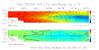 Looking at this image, we can see clearly that the coldest sea surface temperatures are in the eastern portions of this monitoring area. However, when looking at the temperature anomalies (bottom image), we see a more basin-wide La Nina ongoing. We always trust anomalies when looking for a Nino or Nina, because SST's can look cold, but not be as cold as it seems. We can see anomalies well below -0.5 degrees in this monitoring region, clearly indicating a La Nina is in place.
The big question that comes with a La Nina is if it is 'east based' or 'west based'. A 'west based' La Nina is when the coldest anomalies are in the western portions of the monitoring region (top image), while an east based Nina involves the coldest anomalies at the eastern end of the monitoring area. Below are the temperature effects from West and East Based La Ninas.
 The East-Based Nina favors a cooler nation, while West Based La Ninas typically torch the East Coast westwards through into the Plains. Right now, I am expecting this East Based La Nina either to stay where it is, or more likely, spread slightly westward into the center of the ENSO area.
In the last couple days, the NOAA released their winter forecast which recognized the La Nina but also called out an index named the AO that may be the 'wild card' for temperature averages this winter. I've heard quite a few people ask what the AO is.
The AO is the 'Arctic Oscillation' index. It is a varying phenomenon that exists year-round but varies the most in the cold season. Here's an image to offer a better explanation:
If the Arctic Oscillation is positive, the US basically sees more moderate temperatures. However, when in the negative phase, the AO often brings down colder temperatures to the US. For more advanced weather folk, below is a 500 mb heights image showing a typical AO+, AON (AO Neutral) and AO- conditions during the DJF (December, January, February) time frame.
Notice the swath of blue over the eastern US when the AO index is negative (bottom image), and the opposite when positive (top image).
Another factor is the North Atlantic Oscillation (NAO). The NAO is based on pressure differences between the Icelandic Low (a permanent low pressure system stationed over Iceland) and the Azores High (a permanent high pressure stationed over the Azores). When the pressure differences are large, the NAO is considered positive. When the pressure differences are lower, the NAO is considered negative. Below is an image describing it.
 The NAO has major variability and is something special to watch in the winter. Below is an image displaying the effects the NAO has on the US in the winter months.
 When the NAO is positive, the Eastern US is warmer. However, when the NAO is negative, the East US experiences colder and snowier conditions as the jet stream dips southward, releasing colder air into the region. Below is a general overview of the different NAO conditions and subsequent effects thanks to Ian Bell's website:
Did it seem cold last year? If you thought it did, it was. Last year had a negative NAO for much of the winter months. This year, we are getting some indication that the NAO may also be negative this winter, but the specifics remain to be seen.
If you have skipped down, STOP HERE.
Now we have arrived at our winter forecast. All of the above went into our forecast, and this is the best our forecast will get.
 The nation will have a pretty wild winter this year. The North US will experience much above average snowfall in the pink region, which is much of the Upper Midwest, some of the Midwest, and the Great Lakes regions across the board. The Pink area will also define frigid temperatures across the winter as the floodgates holding back the truly brutal Canadian air will spill over into the far Northern Plains/Upper Midwest. The likelihood of above average snowfall for the pink area is so due to this frigid air, which may direct moisture-starved Alberta Clippers southward. In the midst of the frigid air, snow ratios (an inch of water equals 'x' inches of snow) will rise as the colder air is in place. The snow ratios fall when warmer temperatures are in place. The blue area will likely generally be cooler than average, with the potential for above average snowfall, though less than the pink area. This blue area will extend into the Northeast. Despite the early season coastal storm the region experienced, we are unsure if this will be a pattern. This is why we are monitoring the LRC. The LRC is Lezak's Recurring Cycle. The LRC states that between October 1st and November 10th each year, storms that occur in this time frame have potential to re-occur in the next 40-50 days after the original storm happens. This coastal storm was in the time frame. That does indicate that the storm may re-occur, but that does remain to be seen. There is potential for a more icy winter right by the coast during this winter. This icy area extends through the light blue area, which is an area we believe may experience cool spells during the winter. Florida may get in on this, but if they do, it will be infrequent. Florida itself out westward will be very dry, especially into drought-stricken Texas. Texas westward will also be warm, and into the West Coast will be wet as systems move onshore in an attempt to strike the East Coast/Plains/Midwest later on.
 Precipitation for the winter will be much under average counts yet again for the Southern US. We anticipate this drought to be even more prone to occurring, because dry air naturally sucks out moisture from any systems. In turn, droughts create their own high pressure systems that drive away systems that may produce rain in the area. The same precipitation anomalies cannot be forecasted for the Ohio Valley, where above average precipitation will once again be dominant, similar to last year's winter. We are also extending this above average precipitation westward into the Midwest, but with a chance portion added onto the gist.
 Temperatures will nosedive in the Northern Plains and Upper Midwest as the Canadian Air is released into the region, almost as if too much cold air is built up in Canada and is overflowing the floodgates, so to say. This cooler weather will extend southeast throughout the Midwest and northwards back into the Ohio Valley. However, this cooler air will not be nearly as severe compared to the North Plains brutal cold temperatures. Warmer temperatures will be prevalent across the drought-stricken region from Texas westward and northward, forming more of a boundary between Arizona and California this winter. It is possible the warmer temperatures may extend westward. The same can be said for the light blue (cooler) temperatures.
 Notes: Colors have nothing to do with strength, importance, etc. and are only meant to distinguish lines apart.
The storms will be very active this winter. We will be seeing classic Panhandle Hookers come from Oklahoma through the Midwest- a few of whom may even go into the Ohio Valley. A more intense track will take a low and dip it into the Gulf of Mexico, much like dipping a strawberry into chocolate, then shooting the system north. It is important to know that the 'chocolate' (moisture) of the Gulf of Mexico will remain on the 'strawberry' (storm system) as it moves north, therefore increasing precipitation totals. It is also important to realize that the Gulf of Mexico has had a very inactive hurricane season this year. Thus, warmer waters are still on the surface- waters that would usually be mixed in with cooler, deeper waters in the Gulf if a tropical system were to move across the region. Since that has not happened, it is very possible that more moisture than normal could be pulled up into these storms that dip into the Gulf of Mexico. This track will also occur with coastal storms, which are defined by the yellow line. These storms will tread across the Gulf of Mexico, then bolt northward and hug the coast as it 'bombs out' (rapidly strengthens in a short time period). Alberta Clippers (in green) will affect the usual areas in the North Plains but will sink southward in at least several points in time. When this happens, snow is likely to occur in the more southern Midwest regions.


Let's start off with the big point that will be influencing this winter: the La Nina.
First, what is a La Nina? A La Nina is when a specific section of the Pacific Ocean has sea surface temperatures (SST's) at or below -0.5 degrees below normal. That is the definition of the La Nina. However, there are also certain patterns that can be recognized and can strengthen evidence that a La Nina is present but not immediately visible. We will not delve into those and will just go with the SST's.
For those with skills in latitude and longitude, below are the regions monitored for a La Nina/El Nino.

Let's check out what's happened in the last several months in terms of monitoring and see if you can figure out where the La Nina's are. Image runs from Jan. 1st of this year to Oct. 23. Use the coordinates in the image above to find the temperatures below for a certain region.
 |
| Blue line is sea surface temperature. Pay no mind to the light blue line. |
We can see last year's La Nina in effect in January, tapering off to warmer waters during the summer, and sinking back into a La Nina in the last couple months. It is crucial to analyze past conditions in order to make a proper forecast. However, it is also crucial to analyze current conditions.That said, let's take a look at current SST's and temperature anomalies for those areas at the time of writing (October 23).

The big question that comes with a La Nina is if it is 'east based' or 'west based'. A 'west based' La Nina is when the coldest anomalies are in the western portions of the monitoring region (top image), while an east based Nina involves the coldest anomalies at the eastern end of the monitoring area. Below are the temperature effects from West and East Based La Ninas.

In the last couple days, the NOAA released their winter forecast which recognized the La Nina but also called out an index named the AO that may be the 'wild card' for temperature averages this winter. I've heard quite a few people ask what the AO is.
The AO is the 'Arctic Oscillation' index. It is a varying phenomenon that exists year-round but varies the most in the cold season. Here's an image to offer a better explanation:
 |
| Left side: Positive index. Right side: Negative index. Image courtesy of J. Wallace |
 |
| Colors are pressure anomalies. Blue= lower pressure= colder Orange/red=higher pressure=warmer, sunnier |
Another factor is the North Atlantic Oscillation (NAO). The NAO is based on pressure differences between the Icelandic Low (a permanent low pressure system stationed over Iceland) and the Azores High (a permanent high pressure stationed over the Azores). When the pressure differences are large, the NAO is considered positive. When the pressure differences are lower, the NAO is considered negative. Below is an image describing it.


Positive NAO Index | Negative NAO Index |
More and stronger winter storms crossing the Atlantic Ocean on a more northerly track | Fewer and weaker winter storms crossing on a more west-east pathway |
Warm and wet winters in Europe | Moist air into the Mediterranean and cold air to northern Europe |
Cold and dry winters in northern Canada and Greenland | Milder winter temperatures in Greenland |
US east coast experiences mild and wet winter conditions | US east coast experiences more cold air outbreaks and hence snowy weather conditions |
If you have skipped down, STOP HERE.
Now we have arrived at our winter forecast. All of the above went into our forecast, and this is the best our forecast will get.


The storms will be very active this winter. We will be seeing classic Panhandle Hookers come from Oklahoma through the Midwest- a few of whom may even go into the Ohio Valley. A more intense track will take a low and dip it into the Gulf of Mexico, much like dipping a strawberry into chocolate, then shooting the system north. It is important to know that the 'chocolate' (moisture) of the Gulf of Mexico will remain on the 'strawberry' (storm system) as it moves north, therefore increasing precipitation totals. It is also important to realize that the Gulf of Mexico has had a very inactive hurricane season this year. Thus, warmer waters are still on the surface- waters that would usually be mixed in with cooler, deeper waters in the Gulf if a tropical system were to move across the region. Since that has not happened, it is very possible that more moisture than normal could be pulled up into these storms that dip into the Gulf of Mexico. This track will also occur with coastal storms, which are defined by the yellow line. These storms will tread across the Gulf of Mexico, then bolt northward and hug the coast as it 'bombs out' (rapidly strengthens in a short time period). Alberta Clippers (in green) will affect the usual areas in the North Plains but will sink southward in at least several points in time. When this happens, snow is likely to occur in the more southern Midwest regions.

This year’s snowfall will be different from last year, although the pattern may be somewhat similar. We will see above average snowfall through the North Plains into the southern Midwest as some far reaching clippers and/or stronger systems that draw colder air farther south may move through the region. This above average snowfall then extends eastward as we factor in the Nor’easters the northeast region will experience this year. This coastal storm that occurred several days ago we believe has a CHANCE of being in a pattern called the LRC. The LRC (Lezak Recurring Cycle) is a pattern that sets up with low pressure systems from the beginning days of October to November. In this time frame, any of the storms that pass through could happen again 40-50 days away from when that storm happens. That is the LRC in a nutshell. More northerly, we see the much above average snowfall area. We denoted this for several reasons. The first- and probably most important- is considering that temperatures will be downright frigid in the Northern Plains. These cold temperatures will raise snow ratios. Snow ratios is the number of inches of snow you would get out compared to 1 inch of water. An average snow ratio is 1:10, with 1 inch of water equal to 10 inches of snow. In colder environments, ratios will rise, with extreme cases above 1:20. In warmer climates, like the coastal storm we saw just before Halloween this year, snow ratios will fall, resulting in heavier snow. We will likely see these Alberta Clippers sink more southerly than usual, as the frigid air may divert the storms south. Thus, the Upper Midwest south would get the heavier snows. Another reason is for the Panhandle Hooker storms. Panhandle Hookers are storms that hook around the Oklahoma Panhandle and shoot north into the Midwest, usually bringing ample moisture, leaving behind fair amounts of snow. This also affects the Ohio Valley, which is why we have included them in this above average snowfall. Colorado Lows are similar, but curve around Colorado and go north. These typically affect the Plains more than anybody for snowfall.

The national ice threat will once again be similar to last year as temperature boundaries initiate a battle zone when systems move through the region. This ice threat will also occur with Nor'easters that may bring up some warmer air from the South.
Thank you very much for reading this. A lot of time and effort went into this, and we hope you liked it. The releases are not done yet...
Regional times are as follows:
Nationwide Winter Forecast Release: 12:00 PM CDT
Southwest Winter Forecast Release: 12:10 PM CDT
Southeast Winter Forecast Release: 12:20 PM CDT
Northeast Winter Forecast Release: 12:30 PM CDT
Midwest Winter Forecast Release: 12:40 PM CDT
Northwest Winter Forecast Release: 12:50 PM CDT
South Central Plains Winter Forecast Release: 1:00 PM CDT
Southwest Winter Forecast Release: 12:10 PM CDT
Southeast Winter Forecast Release: 12:20 PM CDT
Northeast Winter Forecast Release: 12:30 PM CDT
Midwest Winter Forecast Release: 12:40 PM CDT
Northwest Winter Forecast Release: 12:50 PM CDT
South Central Plains Winter Forecast Release: 1:00 PM CDT
36 comments:
What region is Denver Colorado in? I see it in the southwest maps, midwest maps and northwest maps.
We aren't exactly sure, but the Southwest would probably be the closest region.
charlotte nc is supposed to have how much snow..........?
Not much, but possibly some with the strongest coastal storms amidst a cold outbreak in the north US.
How much snow is Chicago looking to get this Winter? I hope we are not going to get another mega Blizzard that dumps almost two feet of snow on us again like last year. What are the odds of that repeating again this Winter? Also is the most brutal and coldest arctic air going to stay North of Chicago or will it reach us too?
We recently came across an interesting winter forecast from another area indicating that the early winter months may come with 'severe' blizzard conditions, specifically pointing out Chicago.
I am not saying it's true or false, but for our forecast, Chicago ought to be cooler and snowier. I think Chicago has a chance of getting the 'worst winter', so to speak, but arctic air will not be a frequent visitor to the city.
What do you think about Boone Nc? I just moved here and I am looking for snow ;)
So I guess the Philadelphia Pa. region will get hammered once again this year and we will experience above average snowfall?
It's possible, but may not be as severe as last year.
I live in Pittsburgh, PA and we have had very warm weather the past 3 weeks and the extended forecast shows more warm weather. Any thoughts on when this warm weather pattern will change ?
We have stated that our prime date for the cooler weather is mid-December.
I live in West Central CT new the NY state border. Can you give me a brief 2011-2012 forecast? It seems like I'm on the coastal and interior New England forecast. Thanks!
near** typo! ^^^
The Northeast may be wet, but overall temperatures should end up either slightly below/above average.
I live in Tigervile S.C. and I love winter weather!! Do you think we'll be getting some here this year?
You never know with the Southeast. I would expect your area to see at least some flakes fly at some point, but it does depend on when this pattern changes.
How much snow do you think north Jersey will get?
Based on how the winter has turned out this far, snowfall has a chance to turn out slightly above average.
Hey Andrew,
I live in Southern WI, close to Madison. So far this winter, the temps have been for the most part very mild and above average. We have gotten quite a bit of rain in the last month to the point where our grass here is still all green! I love winter, and am really hoping your forecasts are right and we get blasted with snow... When do you expect the temps to stay consistently below zero in my region so that these rain storms start dropping big snows??? Thanks!
As I said on our Facebook Page, the storm track for your area (and the Midwest as a whole) is as it is expected to be. This storm track would favor a very snowy time period for the Midwest. The only problem is the warm air. As soon as the warm air gets out of the way, your area will start to see the snow fall. The only question is when the warm air will move out.
Hi Andrew. We live in Charleston SC. After the brutally hot, humid, forever looooonnnggg summer we had, we sure would love to see some cold/cold'ish weather here. I know the snow chances are slim to none, but what about some cold weather? Thanks! Cassidy
Cassidy: SC ought to be able to get some cooler weather at some point this winter, and some light snow is not out of the question. However, these matters are complicated by the late start to winter.
Do you guys ever do a Canadian version?
Gundeep: We used to, but we are now focusing more on the US.
However, we are debating whether to create a blog, where one could subscribe, to get seasonal forecasts. It would be free. What do you think of that? I'm going to throw it out there in a poll shortly.
EDIT to Gundeep: This idea is no longer possible, unfortunately.
ahh well...from this I can infer that Toronto will get a massive blast on winter once again like the previous year. Which is perfect! I remember the snow day we had on Feb 2.
This winter will be similar to last winter in many aspects, but it will likely be colder.
The west coast has had rain deep into June the last couple years. Does the late fall mean we will again have a long wet spring?
More accurately, southern Oregon/northwest
This is the person from West Central CT: So far it's been very mild and wet, like what you said to me a few weeks ago. Some days it's in the 50's, then for a few days it goes down to the 30's during the day and 20's even teens during the night. When will I be getting a consistent cold/snowy pattern? And what are your thoughts on the NAO for the next few weeks? (I understand it's not easy to predict)
Thanks,
Tom
I live in St. Louis, Missouri. For the past week its been warm and no snow which kind of unusual for us. When is our first chance of snow and will there be more snow than last year? [:
I live in CT and have been seeing more above average highs and lows than below average and near average. The only snow accumulation we've had was the "Snowtober" and have seen all rain since then. Lakes in the hills haven't even formed much ice yet. Will it continue to be a mild and wet winter with hardly and cold spells and more rain than snow? El Nino or La Nina?
Anonymous #1: This winter is unlike others that I have seen, so it is hard to tell. For now, take what conditions you had for fall and use that for this winter, until the pattern change happens.
Tom: The NAO looks to be starting to go towards a negative phase come mid January- that is, if the right levels of the stratosphere warm correctly.
Anonymous #2: Because this winter is much different than winters we have typically seen, I would say that your area will get below normal snowfall in the end. Depending on the cold air available when the pattern change happens.
Anonymous #3: Until the pattern changes, unfortunately yes. When the pattern changes, though, expect snow. A lot of snow.
I'm sorry to the first 2 Anonymous' and Tom for not responding quicker. I didn't see that there were new comments on this page.
I live in MN and it has been quite warm with little snow. When do you think the pattern will change to cold and more snow?
Do you think the Poconos in Pennsylvania will get any snow this winter?
Dustin: The pattern will change in Mid January.
Anonymous: They will, later in the month.
Post a Comment